
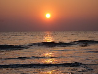
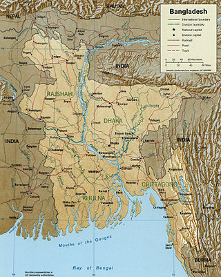
Bangladesh is a densely populated, low-lying, mainly riverine country located in South Asia with a coastline of 580 km (360 mi) on the northern littoral of the Bay of Bengal. The delta plain of the Ganges (Padma), Brahmaputra (Jamuna), and Meghna Rivers and their tributaries occupy 79 percent of the country. Four uplifted blocks occupy 9 percent and steep hill ranges up to approximately 1,000 metres (3,300 ft) high occupy 12 percent in the southeast and in the northeast. Straddling the Tropic of Cancer, Bangladesh has a tropical monsoon climate characterised by heavy seasonal rainfall, high temperatures, and high humidity. Natural disasters such as floods and cyclones accompanied by storm surges periodically affect the country. Most of the country is intensively farmed, with rice the main crop, grown in three seasons. Rapid urbanisation is taking place with associated industrial and commercial development. Exports of garments and shrimp plus remittances from Bangladeshis working abroad provide the country's three main sources of foreign exchange income.

The Brahmaputra is a trans-boundary river which flows through Southwestern China, Northeastern India, and Bangladesh. It is known as Brahmaputra or Luit in Assamese, Yarlung Tsangpo in Tibetan, the Siang/Dihang River in Arunachali, and Jamuna River in Bengali. By itself, it is the 9th largest river in the world by discharge, and the 15th longest.
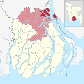
Barisal Division is one of the eight administrative divisions of Bangladesh. Located in the south-central part of the country, it has an area of 13,225 km2 (5,106 sq mi), and a population of 9,325,820 at the 2022 Census. It is the least populous Division in Bangladesh. It is bounded by Dhaka Division on the north, the Bay of Bengal on the south, Chittagong Division on the east and Khulna Division on the west. The administrative capital, Barisal city, lies in the Padma River delta on an offshoot of the Arial Khan River. Barisal division is criss-crossed by numerous rivers that earned it the nickname Dhan-Nodi-Khal, Ei tin-e Borishal.
The Meghna is one of the major rivers in Bangladesh, one of the three that form the Ganges Delta, the largest delta on earth, which fans out to the Bay of Bengal. A part of the Surma-Meghna River System, the Meghna is formed inside Bangladesh in Kishoreganj District above the town of Bhairab Bazar by the joining of the Surma and the Kushiyara, both of which originate in the hilly regions of eastern India as the Barak River. The Meghna meets its major tributary, the Padma, in Chandpur District. Other major tributaries of the Meghna include the Dhaleshwari, the Gumti, and the Feni. The Meghna empties into the Bay of Bengal in Bhola District via four principal mouths, named Tetulia (Ilsha), Shahbazpur, Hatia, and Bamni.

Bhola District is an administrative district (zila) in south-central Bangladesh, which includes Bhola Island, the largest island of Bangladesh. It is located in the Barisal Division and has an area of 3,403.48 km2. It is bounded by Lakshmipur and Barisal District to the north, the Bay of Bengal to the south, by Lakshmipur and Noakhali districts, the (lower) Meghna river and Shahbazpur Channel to the east, and by Patuakhali District and the Tetulia river to the west. About 400 million cubic feet natural gas has been found at Kachia in Bhola which is being used to run a power station.

Lakshmipur is a district in Bangladesh with an area of 1,440 km2. It is bordered by Chandpur to the north, Bhola and Noakhali districts to the south, Noakhali to the east, and Barisal and Bhola districts to the west. Lakshmipur was part of Noakhali until 15 February 1984, when the western part of Noakhali was reorganised from Lakshmipur subdivision into Lakshmipur district to improve administrative efficiency.
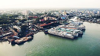
Barisal, officially known as Barishal, is a major city that lies on the banks of the Kirtankhola river in south-central Bangladesh. It is the largest city and the administrative headquarter of both Barisal District and Barisal Division. It is one of the oldest municipalities and river ports of the country. The city was once called the Venice of the East or the Venice of Bengal.
Hizla is the largest upazila (sub-district) of southern Bangladesh's Barisal District.

Mehendigonj is an upazila of Barisal District in Barisal Division, Bangladesh. Mehendigonj is popularly known as Patarhat by the local people.

Lalmohan is an upazila of Bhola District in the Division of Barisal, Bangladesh.

Tazumuddin is an upazila of Bhola District in the Division of Barisal, Bangladesh.

Manpura Island is an island in the northern Bay of Bengal, Bangladesh, at the mouth of the Meghna river. It consists of Manpura upazila, Bhola District. The island has an area of 373 km2. Other major offshore islands of this region are Bhola Island and Hatia Island. All of these islands are densely populated.

Hatiya Island is an island in the northern Bay of Bengal, Bangladesh, at the mouth of the Meghna river. The island falls under Hatiya Upazila of Noakhali District. The island has an area of 480 km2. Other major offshore islands of this region are Bhola Island and Manpura Island. All of these islands are densely populated. It is frequently subject to cyclones and destructive ocean waves.

The Roman Catholic Archdiocese of Chittagong, renamed Chattogram on December 28, 2018, is an archdiocese of the Latin Church of the Catholic Church in Bangladesh. The Archdiocese of Chittagong is the metropolitan see of the ecclesiastical province of Chittagong, which includes the suffragan dioceses of the Roman Catholic Diocese of Khulna and the Roman Catholic Diocese of Barisal, both in Bangladesh. However, it remains dependent on the missionary Roman Congregation for the Evangelization of Peoples.
Ulania is a union parishad of Mehendiganj Upazila in Barisal District, Barisal Division, Bangladesh.

Backergunge, Backergunje, Bakarganj, or Bakerganj is a former district of British Bengal, East Pakistan and Bangladesh. It was the southernmost district of the Dacca Division. The district was located in the swampy lowlands of the vast delta of the Ganges and the Brahmaputra rivers.
Char Monai, also spelt Charmonai, is an administrative union of Barisal District in the division of Barisal in southern-central Bangladesh. It's the spiritual centre of Islami Andolan Bangladesh party.
Dingamanik is a village in Naria Upazila of Shariatpur District under Dhaka Division of southern-central Bangladesh.

Moju Chowdhury Hat is a market village and tourist center in Charramani Mohan Union of Lakshmipur Sadar Upazila in southeastern Bangladesh. According to Banglapedia, the sluice gate on Lakshmipur Khal (canal) is a tourist attraction and a transport hub in southeastern Bangladesh, with over 10,000 travelling passengers per day.


