Biały Kościół, Lower Silesian Voivodeship

Last updated
Biały Kościół
Village
Poland adm location map.svg
Red pog.svg
Biały Kościół
Coordinates: 50°43′50″N17°02′12″E / 50.73056°N 17.03667°E / 50.73056; 17.03667
Country Flag of Poland.svg  Poland
Voivodeship Lower Silesian
County Strzelin
Gmina Strzelin
Highest elevation 203 m (666 ft)
Lowest elevation 180 m (590 ft)
Population 300
Website http://www.bialykosciol.pl
Tree by the lake near Bialy Kosciol Tree by lake Bialy Kosciol.jpg
Tree by the lake near Biały Kościół
Sunset over Bialy Kosciol Sunset Bialy Kosciol.jpg
Sunset over Biały Kościół

Biały Kościół [ˈbjawɨ ˈkɔɕt͡ɕuu̯] is a village in the administrative district of Gmina Strzelin, within Strzelin County, Lower Silesian Voivodeship, in south-western Poland. [1]

Gmina Strzelin is an urban-rural gmina in Strzelin County, Lower Silesian Voivodeship, in south-western Poland. Its seat is the town of Strzelin, which lies approximately 39 kilometres (24 mi) south of the regional capital Wrocław.

Strzelin County County in Lower Silesian, Poland

Strzelin County is a unit of territorial administration and local government (powiat) in Lower Silesian Voivodeship, south-western Poland. It came into being on January 1, 1999, as a result of the Polish local government reforms passed in 1998. The county covers an area of 622.3 square kilometres (240.3 sq mi). Its administrative seat is the town of Strzelin, and its only other town is Wiązów.

Lower Silesian Voivodeship Voivodeship in Poland

Lower Silesian Voivodeship, or Lower Silesia Province, in southwestern Poland, is one of the 16 voivodeships (provinces) into which Poland is divided.

It lies approximately 7 kilometres (4 mi) south of Strzelin, and 44 kilometres (27 mi) south of the regional capital Wrocław.

Wrocław Place in Lower Silesian Voivodeship, Poland

Wrocław is a city in western Poland and the largest city in the historical region of Silesia. It lies on the banks of the River Oder in the Silesian Lowlands of Central Europe, roughly 350 kilometres (220 mi) from the Baltic Sea to the north and 40 kilometres (25 mi) from the Sudeten Mountains to the south. The population of Wrocław in 2018 was 639,258, making it the fourth-largest city in Poland and the main city of Wrocław agglomeration.

The village has a population of 300.

Related Research Articles

Boreczek, Lower Silesian Voivodeship Village in Lower Silesian, Poland

Boreczek is a village in the administrative district of Gmina Borów, within Strzelin County, Lower Silesian Voivodeship, in south-western Poland.

Samborowiczki Village in Lower Silesian, Poland

Samborowiczki is a village in the administrative district of Gmina Przeworno, within Strzelin County, Lower Silesian Voivodeship, in south-western Poland. Prior to 1945 it was in Germany.

Bierzyn, Lower Silesian Voivodeship Village in Lower Silesian, Poland

Bierzyn is a village in the administrative district of Gmina Strzelin, within Strzelin County, Lower Silesian Voivodeship, in south-western Poland. Prior to 1945 it was in Germany.

Brożec, Lower Silesian Voivodeship Village in Lower Silesian, Poland

Brożec is a village in the administrative district of Gmina Strzelin, within Strzelin County, Lower Silesian Voivodeship, in south-western Poland.

Chociwel, Lower Silesian Voivodeship Village in Lower Silesian, Poland

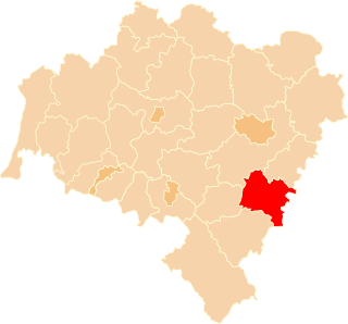
Chociwel is a village in the administrative district of Gmina Strzelin, within Strzelin County, Lower Silesian Voivodeship, in south-western Poland. It lies approximately 3 kilometres (2 mi) north-east of Strzelin, and 37 kilometres (23 mi) south of the regional capital Wrocław.

Dankowice, Strzelin County Village in Lower Silesian, Poland

Dankowice is a village in the administrative district of Gmina Strzelin, within Strzelin County, Lower Silesian Voivodeship, in south-western Poland. Prior to 1945 it was in Germany.

Dębniki, Lower Silesian Voivodeship Village in Lower Silesian, Poland

Dębniki is a village in the administrative district of Gmina Strzelin, within Strzelin County, Lower Silesian Voivodeship, in south-western Poland. Prior to 1945 it was in Germany.

Dobrogoszcz, Lower Silesian Voivodeship Village in Lower Silesian, Poland

Dobrogoszcz is a village in the administrative district of Gmina Strzelin, within Strzelin County, Lower Silesian Voivodeship, in south-western Poland. Prior to 1945 it was in Germany.

Gębice, Lower Silesian Voivodeship Village in Lower Silesian, Poland

Gębice is a village in the administrative district of Gmina Strzelin, within Strzelin County, Lower Silesian Voivodeship, in south-western Poland. Prior to 1945 it was in Germany.

Gębczyce Village in Lower Silesian, Poland

Gębczyce is a village in the administrative district of Gmina Strzelin, within Strzelin County, Lower Silesian Voivodeship, in south-western Poland. Prior to 1945 it was in Germany.

Gościęcice Village in Lower Silesian, Poland

Gościęcice, formerly known as Mehltheuer, is a village in the administrative district of Gmina Strzelin, within Strzelin County, Lower Silesian Voivodeship, in south-western Poland. Prior to 1945, it was in Germany.

Kazanów, Lower Silesian Voivodeship Village in Lower Silesian, Poland

Kazanów is a village in the administrative district of Gmina Strzelin, within Strzelin County, Lower Silesian Voivodeship, in south-western Poland.

Pęcz Village in Lower Silesian, Poland

Pęcz is a village in the administrative district of Gmina Strzelin, within Strzelin County, Lower Silesian Voivodeship, in south-western Poland. Prior to 1945, it was in Germany.

Skoroszowice Village in Lower Silesian, Poland

Skoroszowice is a village in the administrative district of Gmina Strzelin, within Strzelin County, Lower Silesian Voivodeship, in south-western Poland. Prior to 1945 it was in Germany.

Szczodrowice Village in Lower Silesian, Poland

Szczodrowice is a village in the administrative district of Gmina Strzelin, within Strzelin County, Lower Silesian Voivodeship, in south-western Poland. Prior to 1945 it was in Germany.

Trześnie Village in Lower Silesian, Poland

Trześnie is a village in the administrative district of Gmina Strzelin, within Strzelin County, Lower Silesian Voivodeship, in south-western Poland. Prior to 1945 it was in Germany.

Gliczyna Village in Lower Silesian, Poland

Gliczyna is a village in the administrative district of Gmina Strzelin, within Strzelin County, Lower Silesian Voivodeship, in south-western Poland. Prior to 1945 it was in Germany.

Kaczów Village in Lower Silesian, Poland

Kaczów is a village in the administrative district of Gmina Strzelin, within Strzelin County, Lower Silesian Voivodeship, in south-western Poland. Prior to 1945 it was in Germany.

Zimne Doły Village in Lower Silesian, Poland

Zimne Doły is a village in the administrative district of Gmina Strzelin, within Strzelin County, Lower Silesian Voivodeship, in south-western Poland. Prior to 1945 it was in Germany.

Psary, Świętokrzyskie Voivodeship Village in Świętokrzyskie, Poland

Psary is a village in the administrative district of Gmina Secemin, within Włoszczowa County, Świętokrzyskie Voivodeship, in south-central Poland. It lies approximately 5 kilometres (3 mi) south of Secemin, 18 km (11 mi) south-west of Włoszczowa, and 59 km (37 mi) west of the regional capital Kielce.

References

Coordinates: 50°43′50″N17°02′12″E / 50.73056°N 17.03667°E / 50.73056; 17.03667

Geographic coordinate system Coordinate system

A geographic coordinate system is a coordinate system that enables every location on Earth to be specified by a set of numbers, letters or symbols. The coordinates are often chosen such that one of the numbers represents a vertical position and two or three of the numbers represent a horizontal position; alternatively, a geographic position may be expressed in a combined three-dimensional Cartesian vector. A common choice of coordinates is latitude, longitude and elevation. To specify a location on a plane requires a map projection.