Opatowice is a village in the administrative district of Gmina Borów, within Strzelin County, Lower Silesian Voivodeship, in south-western Poland. Prior to 1945 it was in Germany. It lies approximately 4 kilometres (2 mi) south-east of Borów, 10 km (6 mi) north of Strzelin, and 29 km (18 mi) south of the regional capital Wrocław.
Lipowa is a village in the administrative district of Gmina Kondratowice, within Strzelin County, Lower Silesian Voivodeship, in south-western Poland. Prior to 1945 it was in Germany. It lies approximately 7 kilometres (4 mi) south-east of Kondratowice, 8 km (5 mi) south-west of Strzelin, and 44 km (27 mi) south of the regional capital Wrocław.
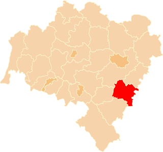
Królewiec is a village in the administrative district of Gmina Przeworno, within Strzelin County, Lower Silesian Voivodeship, in south-western Poland. Prior to 1945 it was in Germany. It lies approximately 15 kilometres (9 mi) east of Przeworno, 15 km (9 mi) south-east of Strzelin, and 49 km (30 mi) south of the regional capital Wrocław.
Wieliczka is a village in the administrative district of Gmina Przeworno, within Strzelin County, Lower Silesian Voivodeship, in south-western Poland. Prior to 1945 it was in Germany. It lies approximately 17 kilometres (11 mi) east of Przeworno, 19 km (12 mi) south-east of Strzelin, and 54 km (34 mi) south of the regional capital Wrocław.
Dankowice is a village in the administrative district of Gmina Strzelin, within Strzelin County, Lower Silesian Voivodeship, in south-western Poland. Prior to 1945 it was in Germany.
Głęboka is a village in the administrative district of Gmina Strzelin, within Strzelin County, Lower Silesian Voivodeship, in south-western Poland. Prior to 1945 it was in Germany. It lies approximately 6 kilometres (4 mi) east of Strzelin and 41 km (25 mi) south of the regional capital Wrocław.
Krzepice is a village in the administrative district of Gmina Strzelin, within Strzelin County, Lower Silesian Voivodeship, in south-western Poland. Prior to 1945 it was in Germany. It lies approximately 5 kilometres (3 mi) east of Strzelin and 39 km (24 mi) south of the regional capital Wrocław.
Piotrowice is a village in the administrative district of Gmina Strzelin, within Strzelin County, Lower Silesian Voivodeship, in south-western Poland. Prior to 1945 it was in Germany. It lies approximately 5 kilometres (3 mi) west of Strzelin and 39 km (24 mi) south of the regional capital Wrocław.
Pławna is a village in the administrative district of Gmina Strzelin, within Strzelin County, Lower Silesian Voivodeship, in south-western Poland. Prior to 1945 it was in Germany. It lies approximately 7 kilometres (4 mi) north-east of Strzelin and 33 km (21 mi) south of the regional capital Wrocław.
Strzegów is a village in the administrative district of Gmina Strzelin, within Strzelin County, Lower Silesian Voivodeship, in south-western Poland. Prior to 1945 it was in Germany. It lies approximately 4 kilometres (2 mi) south of Strzelin and 42 km (26 mi) south of the regional capital Wrocław.
Szczawin is a village in the administrative district of Gmina Strzelin, within Strzelin County, Lower Silesian Voivodeship, in south-western Poland. Prior to 1945 it was in Germany. It lies approximately 39 km (24 mi) south of the regional capital Wrocław.
Krajno is a village in the administrative district of Gmina Wiązów, within Strzelin County, Lower Silesian Voivodeship, in south-western Poland. Prior to 1945 it was in Germany. It lies approximately 8 kilometres (5 mi) south-east of Wiązów, 14 km (9 mi) east of Strzelin, and 45 km (28 mi) south of the regional capital Wrocław.
Witowice is a village in the administrative district of Gmina Wiązów, within Strzelin County, Lower Silesian Voivodeship, in south-western Poland. Prior to 1945 it was in Germany. It lies approximately 3 kilometres (2 mi) north-east of Wiązów, 12 km (7 mi) north-east of Strzelin, and 35 km (22 mi) south of the regional capital Wrocław.
Zborowice is a village in the administrative district of Gmina Wiązów, within Strzelin County, Lower Silesian Voivodeship, in south-western Poland. Prior to 1945 it was in Germany. It lies approximately 3 kilometres (2 mi) south-west of Wiązów, 9 km (6 mi) east of Strzelin, and 38 km (24 mi) south of the regional capital Wrocław.
Skórzewo is a village in the administrative district of Gmina Szubin, within Nakło County, Kuyavian-Pomeranian Voivodeship, in north-central Poland. It lies approximately 6 kilometres (4 mi) north-east of Szubin, 19 km (12 mi) south-east of Nakło nad Notecią, and 15 km (9 mi) south-west of Bydgoszcz.
Niewino Leśne is a village in the administrative district of Gmina Wyszki, within Bielsk County, Podlaskie Voivodeship, in north-eastern Poland. It lies approximately 6 kilometres (4 mi) south-east of Wyszki, 12 km (7 mi) north-west of Bielsk Podlaski, and 35 km (22 mi) south of the regional capital Białystok.
Jeńki is a village in the administrative district of Gmina Sokoły, within Wysokie Mazowieckie County, Podlaskie Voivodeship, in north-eastern Poland. It lies approximately 11 kilometres (7 mi) north-east of Sokoły, 25 km (16 mi) north-east of Wysokie Mazowieckie, and 25 km (16 mi) west of the regional capital Białystok.
Grójec is a village in the administrative district of Gmina Czernice Borowe, within Przasnysz County, Masovian Voivodeship, in east-central Poland. It lies approximately 7 kilometres (4 mi) east of Czernice Borowe, 6 km (4 mi) north-west of Przasnysz, and 94 km (58 mi) north of Warsaw.
Piotrów is a village in the administrative district of Gmina Blizanów, within Kalisz County, Greater Poland Voivodeship, in west-central Poland. It lies approximately 10 kilometres (6 mi) south of Blizanów, 7 km (4 mi) north of Kalisz, and 101 km (63 mi) south-east of the regional capital Poznań.
Sulimy is a village in the administrative district of Gmina Giżycko, within Giżycko County, Warmian-Masurian Voivodeship, in northern Poland. It lies approximately 4 kilometres (2 mi) east of Giżycko and 92 km (57 mi) east of the regional capital Olsztyn.