
Clay County is a county located in the U.S. state of Kentucky. As of the 2020 census, the county population was 20,345. Its county seat is Manchester. The county was formed in 1807 and named in honor of Green Clay (1757–1826). Clay was a member of the Virginia and Kentucky State legislatures, first cousin once removed of Henry Clay, U.S. Senator from Kentucky and Secretary of State in the 19th century.

The Red River Gorge is a canyon system on the Red River in east-central Kentucky. Geologically it is part of the Pottsville Escarpment.

Grayson County is a county located in the U.S. state of Kentucky. As of the 2020 census, the population was 26,420. Its county seat is Leitchfield. The county was formed in 1810 and named for William Grayson (1740-1790), a Revolutionary War colonel and a prominent Virginia political figure. Grayson County was formerly a prohibition or dry county, but Leitchfield allowed limited alcohol sales in restaurants in 2010 and voted "wet" in 2016.
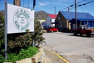
Allen, also known as Allen City, is a home rule-class city in Floyd County, Kentucky, in the United States. The population was 193 at the 2010 census, up from 150 at the 2000 census.

Independence is a home rule-class city in Kenton County, Kentucky, in the United States. It is one of its county's two seats of government. The population was 24,757 at the time of the 2010 U.S. census, up from 14,982 at the 2000 census. It is the third largest city in Northern Kentucky after Covington and Florence.

Hyden is a home rule-class city in and the county seat of Leslie County, Kentucky, United States. The population was 365 at the 2010 census. It is located at the junction of U.S. Route 421 and Kentucky Route 80, along the Middle Fork of the Kentucky River.

Science Hill is a home rule-class city in Pulaski County, Kentucky, in the United States. The population was 693 as of the 2010 U.S. Census.

Clifty Falls State Park is an Indiana state park on 1,416 acres (573 ha) in Jefferson County, Indiana in the United States. It is 46 miles (74 km) northeast of Louisville, Kentucky. The park attracts about 370,000 visitors annually.

Kyger Creek Power Plant is a 1.08-gigawatt, 1,086 (MW) coal-fired power station located south of Cheshire, Ohio in Gallia County, Ohio. It is operated by the Ohio Valley Electric Corporation (OVEC).

Clifty Creek Power Plant is a 1,300-MW coal-fired power station located in Madison, Indiana. Clifty Creek is operated by the Indiana Kentucky Electric Corporation. It is named after Clifty Creek, which enters the Ohio River nearby.

Indiana's 6th congressional district is a congressional district in the U.S. state of Indiana. The district takes in a portion of eastern and central Indiana as of the 2020 census, including Columbus and Richmond, some of Cincinnati's Indiana suburbs, most of Indianapolis' southern suburbs, and a sliver of Indianapolis itself.

Taylor Township is one of fifteen townships in Greene County, Indiana, USA. At the 2010 census, its population was 1,200.

Clay Township is one of twelve townships in Bartholomew County, Indiana, United States. As of the 2010 census, its population was 3,271 and it contained 1,320 housing units.
Columbus Township is one of twelve townships in Bartholomew County, Indiana, United States. As of the 2010 census, its population was 45,578 and it contained 20,516 housing units.

Clay Township is one of nine townships in Decatur County, Indiana. As of the 2010 census, its population was 1,287 and it contained 535 housing units.

Jackson Township is one of nine townships in Decatur County, Indiana. As of the 2010 census, its population was 988 and it contained 419 housing units.

Madison Township is one of ten townships in Jefferson County, Indiana, United States. As of the 2010 census, its population was 17,415 and it contained 8,087 housing units.
Clifty Wilderness is a 13,344-acre (54 km2) wilderness area located in the US state of Kentucky. It was designated wilderness in 1985 and is managed by the Cumberland Ranger District of the Daniel Boone National Forest.
The Ohio Valley Electric Corporation (OVEC) is a company jointly owned by several parent electrical utilities. It is headquartered in Piketon, Ohio. OVEC and its wholly-owned subsidiary, Indiana-Kentucky Electrical Corporation (IKEC), own and operate two coal-fired electrical generating plants. They are the Kyger Creek Power Plant, located near Gallipolis, Ohio, and the Clifty Creek Power Plant near Madison, Indiana.

Kentucky Route 107 (KY 107) is a 56.907-mile-long (91.583 km) east–west state highway in west–central Kentucky. The western (southern) terminus of the route is an "end of state maintenance" terminus near the Fort Campbell military reservation south of Donaldson Creek near La Fayette, and its northern (eastern) terminus is at an intersection with U.S. Route 431 (US 431) in Lewisburg.

