Big Dam Bridge

Last updated
Pulaski County Pedestrian and Bicycle Bridge
Big Dam Bridge 2.jpg
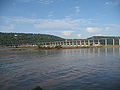
The Big Dam Bridge as seen from the Arkansas River Trail in Little Rock
Coordinates Coordinates: 34°47′38″N92°21′29″W / 34.793911°N 92.358069°W / 34.793911; -92.358069
Carries Pedestrians and bicycles
Crosses Arkansas River
Locale Little Rock, Arkansas
North Little Rock, Arkansas
Official namePulaski County Pedestrian and Bicycle Bridge
Other name(s)Big Dam Bridge
Characteristics
Total length4,226 feet (1,288 m)
Width14 feet (4 m)
History
OpenedSeptember 30, 2006
Location
Big Dam Bridge

Originally intended to be called Murray Bridge, the Big Dam Bridge in Arkansas spans the Arkansas River and Murray Lock and Dam between Little Rock and North Little Rock and is open only to pedestrian and bicycle traffic. At 4,226 feet (1288 m) in length it is the longest pedestrian/bicycle bridge in North America that has never been used by trains or motor vehicles. It rises to 90 feet (27 m) over the Arkansas River and 30 feet (9.1 m) over the dam. The span over the river is 3,463 feet (1055 m), with the ramps on either side of the river accounting for the rest of the length. The southern end of the bridge is near Little Rock's Murray Park, while the northern end is at Cook's Landing Park in North Little Rock. [1]

Contents

The nickname was given by Pulaski County Judge F.G. “Buddy” Villines, who was concerned about the financing needed and was quoted to say, "We're going to build that dam bridge." (He insisted he was referring to its location on a dam, and was not using the mild expletive.) The construction cost was $12.8 million.

The opening ceremony was held on Saturday, September 30, 2006. Local politicians boasted that the bridge will boost the local economy and contribute to the health of the population. The bridge and adjacent parks are used for several races including the Big Dam Bridge 100 cycling tour, the BDB Twilight 5k race, and the BDB Duathlon.

The Federal Highway Administration gave one of its first Exemplary Human Environment Initiative awards to the bridge, and Illuminating Engineer Society gave its Award of Merit at the international level to the bridge's LED lighting design.

Related Research Articles

<span class="mw-page-title-main">Mississippi River</span> Major river in the United States

The Mississippi River is the second-longest river and chief river of the second-largest drainage system in North America, second only to the Hudson Bay drainage system. From its traditional source of Lake Itasca in northern Minnesota, it flows generally south for 2,340 miles (3,770 km) to the Mississippi River Delta in the Gulf of Mexico. With its many tributaries, the Mississippi's watershed drains all or parts of 32 U.S. states and two Canadian provinces between the Rocky and Appalachian mountains. The main stem is entirely within the United States; the total drainage basin is 1,151,000 sq mi (2,980,000 km2), of which only about one percent is in Canada. The Mississippi ranks as the thirteenth-largest river by discharge in the world. The river either borders or passes through the states of Minnesota, Wisconsin, Iowa, Illinois, Missouri, Kentucky, Tennessee, Arkansas, Mississippi, and Louisiana.

<span class="mw-page-title-main">Maumelle, Arkansas</span> City in Arkansas, United States

Maumelle is a city in Pulaski County, Arkansas, United States. As of the 2020 census, the city's population was 19,251. The city is located northwest of Little Rock, bordering the opposite shore of the Arkansas River and is part of the Little Rock metropolitan area.

<span class="mw-page-title-main">Boise greenbelt</span>

The Boise River Greenbelt is a recreational and alternate transportation trail along the banks of the Boise River through Boise, Idaho, United States. The Boise Greenbelt is more of a greenway than a green belt since its character is linear. It extends more than 20 miles (32 km) beginning at Lucky Peak Dam in the east to a short distance beyond Eagle Road in the west in Eagle, Idaho. Taking into account both sides of the river and other parallel trails and spurs, the total Greenbelt trail system measures more than 30 miles (48 km).

<span class="mw-page-title-main">Sellwood Bridge</span> Bridge in Portland, OR

The Sellwood Bridge is a deck arch bridge that spans the Willamette River in Portland, Oregon, in the United States. The current bridge opened in 2016 and replaced a 1925 span that had carried the same name. The original bridge was Portland's first fixed-span bridge and, being the only river crossing for miles in each direction, the busiest two-lane bridge in Oregon. The Sellwood Bridge links the Sellwood and Westmoreland neighborhoods of Portland on the east side with Oregon Route 43/Macadam Avenue on the west side. At its east end it leads to Tacoma Street. The bridge is owned and operated by Multnomah County. The original span of 1925 was a steel truss bridge, while its 2016 replacement is a deck-arch-type bridge.

<span class="mw-page-title-main">Footbridge</span> Bridge designed solely for pedestrians

A footbridge is a bridge designed solely for pedestrians. While the primary meaning for a bridge is a structure which links "two points at a height above the ground", a footbridge can also be a lower structure, such as a boardwalk, that enables pedestrians to cross wet, fragile, or marshy land. Bridges range from stepping stones–possibly the earliest man-made structure to "bridge" water–to elaborate steel structures. Another early bridge would have been simply a fallen tree. In some cases a footbridge can be both functional and artistic.

<span class="mw-page-title-main">Walnut Street Bridge (Chattanooga)</span> United States historic place

Built in 1890, the 2,376-foot-long (724 m) Walnut Street Bridge connects Chattanooga, Tennessee's downtown with North Chattanooga. The bridge's main spans are pin-connected Pennsylvania through truss spans. The top chord of these truss spans are configured in five sections, making the spans similar to the Camelback truss design. The bridge is historically significant as an extremely long and old example of its type; according to the Historic American Engineering Record: "The bridge was apparently the first non-military highway bridge across the Tennessee River."

<span class="mw-page-title-main">Chain of Rocks Bridge</span> Footbridge on the Mississippi River in St. Louis, Missouri

The old Chain of Rocks Bridge spans the Mississippi River on the north edge of St. Louis, Missouri. The eastern end of the bridge is on Chouteau Island, while the western end is on the Missouri shoreline. Its most notable feature is a 22-degree bend occurring at the middle of the crossing.

<span class="mw-page-title-main">Table Rock Lake</span> Man-made lake in Missouri and Arkansas, United States

Table Rock Lake is an artificial lake or reservoir in the Ozarks of southwestern Missouri and northwestern Arkansas in the United States. Designed, built and operated by the U.S. Army Corps of Engineers, the lake is impounded by Table Rock Dam, which was constructed from 1954 to 1958 on the White River.

<span class="mw-page-title-main">Mike O'Callaghan–Pat Tillman Memorial Bridge</span> Arch bridge over the Colorado River at Hoover Dam, United States

The Mike O'Callaghan–Pat Tillman Memorial Bridge is an arch bridge in the United States that spans the Colorado River between the states of Arizona and Nevada. The bridge is located within the Lake Mead National Recreation Area approximately 30 miles (48 km) southeast of Las Vegas, and carries Interstate 11 and U.S. Route 93 over the Colorado River. Opened in 2010, it was the key component of the Hoover Dam Bypass project, which rerouted US 93 from its previous routing along the top of Hoover Dam and removed several hairpin turns and blind curves from the route. It is jointly named for Mike O'Callaghan, Governor of Nevada from 1971 to 1979, and Pat Tillman, an American football player who left his career with the Arizona Cardinals to enlist in the United States Army and was killed in Afghanistan in 2004 by friendly fire.

<span class="mw-page-title-main">John Seigenthaler Pedestrian Bridge</span> Cumberland River span in Nashville (USA)

The John Seigenthaler Pedestrian Bridge is a truss bridge that spans the Cumberland River in Nashville, Tennessee, United States. The bridge spans 3,150 feet (960 m) and is one of the longest pedestrian bridges in the world.

<span class="mw-page-title-main">Columbia–Wrightsville Bridge</span> Road and sidewalk overpass in Pennsylvania

The Columbia–Wrightsville Bridge, officially the Veterans Memorial Bridge, spans the Susquehanna River between Columbia and Wrightsville, Pennsylvania, and carries Pennsylvania Route 462 and BicyclePA Route S. Built originally as the Lancaster-York Intercounty Bridge, construction began in 1929, and the bridge opened September 30, 1930. On November 11, 1980, it was officially dedicated as Veterans Memorial Bridge, though it is still referenced locally as the Columbia–Wrightsville Bridge.

<span class="mw-page-title-main">Frisco Bridge</span> Bridge in Arkansas and Memphis, Tennessee

The Frisco Bridge, previously known as the Memphis Bridge, is a cantilevered through truss bridge carrying a rail line across the Mississippi River between West Memphis, Arkansas, and Memphis, Tennessee.

<span class="mw-page-title-main">Harahan Bridge</span> Bridge between Arkansas and Tennessee, US

The Harahan Bridge is a cantilevered through truss bridge that carries two rail lines and a pedestrian bridge across the Mississippi River between West Memphis, Arkansas, and Memphis, Tennessee. The bridge is owned and operated by Union Pacific Railroad and is the second longest pedestrian/bicycle bridge in the United States. It was built with roadways cantilevered off the sides of the main structure for vehicles. These roadways are owned by the cities of Memphis, Tennessee, and Crittenden County, Arkansas, and were used from 1917–1949, until the Memphis & Arkansas Bridge opened 400 feet (120 m) south of the Harahan. The bridge was named in honor of railroad executive James Theodore Harahan, former president of the Illinois Central Railroad, who was killed in a railroad accident during the construction of the bridge. In February 2011, Union Pacific Railroad officials agreed to the idea of converting the 1917 roadways into a bicycle-pedestrian walkway across the river. In June 2012, Memphis was awarded a $14.9 million federal grant to build the walkway. The overall project was expected to cost $30 million, of which about $11 million was used for the Harahan Bridge portion. Construction was completed in 2016.

<span class="mw-page-title-main">Big Four Bridge</span> Pedestrian bridge that crosses the Ohio River at Louisville, KY

The Big Four Bridge is a six-span former railroad truss bridge that crosses the Ohio River, connecting Louisville, Kentucky, and Jeffersonville, Indiana. It was completed in 1895, updated in 1929, taken out of rail service in 1968, and converted to bicycle and pedestrian use in 2014. The largest single span is 547 feet (167 m), with the entire bridge spanning 2,525 feet (770 m). It took its name from the defunct Cleveland, Cincinnati, Chicago and St. Louis Railway, which was nicknamed the "Big Four Railroad".

<span class="mw-page-title-main">Lamar Boulevard Bridge</span> Historic bridge in Austin, Texas

The Lamar Boulevard Bridge is a historic arch bridge carrying Texas State Highway Loop 343 over Lady Bird Lake in downtown Austin, Texas, United States. The bridge features six open-spandrel concrete arches spanning 659 feet (201 m) and carries tens of thousands of vehicles daily across the lake. Completed in 1942, the Lamar Boulevard Bridge was the second permanent bridge to cross the Colorado River, and one of the last Art Deco-style open-spandrel concrete arch bridges built in Texas. The bridge was named an Austin Landmark in 1993 and added to the National Register of Historic Places in 1994.

<span class="mw-page-title-main">Arkansas River Trail</span> Recreational rail trail in Arkansas, United States

The Arkansas River Trail is a rail trail that runs 17 miles (27 km) in along both sides of the Arkansas River in Central Arkansas.

<span class="mw-page-title-main">Old Blenheim Bridge</span> Wooden covered bridge that spanned Schoharie Creek in North Blenheim, New York, United States

Old Blenheim Bridge was a wooden covered bridge that spanned Schoharie Creek in North Blenheim, New York, United States. With an open span of 210 feet (64 m), it had the second longest span of any surviving single-span covered bridge in the world. The 1862 Bridgeport Covered Bridge in Nevada County, California, currently undergoing repairs due to 1986 flooding is longer overall at 233 feet (71 m) but is argued to have a 208 feet (63 m) clear span. The bridge, opened in 1855, was also one of the oldest of its type in the United States. It was destroyed by flooding resulting from Tropical Storm Irene in 2011. Rebuilding of the bridge commenced in 2017 and was completed in 2018.

<span class="mw-page-title-main">Loch Raven Reservoir</span> Body of water

The Loch Raven Reservoir is a reservoir that provides drinking water for the City of Baltimore and most of Baltimore County, Maryland. It is fed by the Big Gunpowder Falls river, and has a capacity of 23 billion US gallons (87,000,000 m3) of water.

<span class="mw-page-title-main">Elizabethton Covered Bridge</span> United States historic place

The Elizabethton Covered Bridge is a 134-foot (41 m) covered bridge over the Doe River in Elizabethton, the county seat of Carter County, Tennessee.

<span class="mw-page-title-main">Highway 79 Bridge</span> United States historic place

The Highway 79 Bridge was a historic bridge in Clarendon, Arkansas. It was a tall two-span Warren truss bridge, formerly carrying two-lane U.S. Route 79 (US 79), a major arterial highway in the region, across the White River just west of the city's downtown. The steel truss had a total length of 720 feet (220 m), set on four concrete piers. The outer pairs of piers were 160 feet (49 m) apart, and the middle pair were 400 feet (120 m) apart. The approaches were concrete, set on concrete pilings, with the western approach continuing for some 3 miles (4.8 km) across secondary water bodies. The bridge was built in 1930-31 by the Austin Bridge Company.

References

  1. "Big Dam Bridge". Arkansas.com. Retrieved 2019-03-28.