
The Great Dividing Range, also known as the East Australian Cordillera or the Eastern Highlands, is a cordillera system in eastern Australia consisting of an expansive collection of mountain ranges, plateaus and rolling hills, that runs roughly parallel to the east coast of Australia and forms the fifth-longest land-based mountain chain in the world, and the longest entirely within a single country. It is mainland Australia's most substantial topographic feature and serves as the definitive watershed for the river systems in eastern Australia, hence the name.

Bendigo is a city in Victoria, Australia, located in the Bendigo Valley near the geographical centre of the state and approximately 150 kilometres (93 mi) north-west of Melbourne, the state capital.

Juab County is a county in western Utah, United States. As of the 2010 United States Census, the population was 10,246. Its county seat and largest city is Nephi.

The San Gabriel Mountains are a mountain range located in northern Los Angeles County and western San Bernardino County, California, United States. The mountain range is part of the Transverse Ranges and lies between the Los Angeles Basin and the Mojave Desert, with Interstate 5 to the west and Interstate 15 to the east. The range lies in, and is surrounded by, the Angeles and San Bernardino National Forests, with the San Andreas Fault as its northern border.

Castlemaine is a small city in Victoria, Australia, in the Goldfields region about 120 kilometres northwest by road from Melbourne and about 40 kilometres from the major provincial centre of Bendigo. It is the administrative and economic centre of the Shire of Mount Alexander. The population at the 2021 Census was 7,506. Castlemaine was named by the chief goldfield commissioner, Captain W. Wright, in honour of his Irish uncle, Viscount Castlemaine.

U.S. Route 522 is a spur route of US 22 in the states of Virginia, West Virginia, Maryland, and Pennsylvania. The U.S. Highway travels in a north-south direction, and runs 308.59 miles (496.63 km) from US 60 near Powhatan, Virginia, to its northern terminus at US 11 and US 15 near Selinsgrove, Pennsylvania. US 522 serves many small cities and towns in the Piedmont, Blue Ridge Mountains, and northern Shenandoah Valley of Virginia. The highway serves the Virginia communities of Goochland, Mineral, Culpeper, the town of Washington, and Front Royal and the independent city of Winchester. US 522 then follows the Ridge-and-Valley Appalachians north and then east through the Eastern Panhandle of West Virginia, a 2-mile-wide (3.2 km) stretch of Western Maryland, and South Central Pennsylvania to its terminus in the Susquehanna Valley. The highway serves Berkeley Springs, West Virginia; Hancock, Maryland; and the Pennsylvania communities of McConnellsburg, Mount Union, Lewistown, and Middleburg.

New York State Route 36 (NY 36) is a north–south state highway in the western part of New York in the United States. The highway extends for 95 miles (153 km) from the Pennsylvania state line at Troupsburg, Steuben County northward to Ogden, Monroe County, where it ends at an intersection with NY 31. Along the way, NY 36 passes through the villages of Canisteo, Dansville, Mount Morris, Caledonia, and Churchville and the city of Hornell. The section of the route between Dansville and Mount Morris closely parallels Interstate 390 (I-390); however, from Dansville south and Mount Morris north, NY 36 serves as a regionally important highway, connecting to I-86, U.S. Route 20A (US 20A), US 20, and I-490 as it heads north. At its south end, NY 36 connects to Pennsylvania Route 249 (PA 249).

Taradale is a small town in Victoria, Australia. It is located beside the Calder Highway between Melbourne and Bendigo. Its local government area is the Shire of Mount Alexander. At the 2016 census, Taradale had a population of 448.

Penns Valley is an eroded anticlinal valley of the Pennsylvania ridge and valley geologic region of the Appalachian Mountain range. The valley is located in southern Centre County, Pennsylvania. Along with the Nittany Valley to the north and east, it is part of the larger Nittany Anticlinorium. It is bordered by Mount Nittany to the north, the Seven Mountains range to the south, and connects to the larger Nittany Valley to the west. There are two smaller subordinate valleys typically associated with the greater valley: Georges Valley in the south, separated by Egg Hill, and Brush Valley in the north, separated by Brush Mountain.

U.S. Route 40 in the U.S. state of Maryland runs from Garrett County in Western Maryland to Cecil County in the state's northeastern corner. With a total length of 221 miles (356 km), it is the longest numbered highway in Maryland. Almost half of the road overlaps or parallels with Interstate 68 (I-68) or I-70, while the old alignment is generally known as US 40 Alternate, US 40 Scenic, or Maryland Route 144. West of Baltimore, in the Piedmont and Appalachian Mountains / Blue Ridge region of the Western Maryland panhandle of the small state, the portions where it does not overlap an Interstate highway are mostly two-lane roads. The portion northeast of Baltimore going toward Wilmington in northern Delaware and Philadelphia in southeastern Pennsylvania is a four-lane divided highway, known as the Pulaski Highway. This section crosses the Susquehanna River at the north end of the Chesapeake Bay on the Thomas J. Hatem Memorial Bridge.

Mount Alexander Road is a major road in Melbourne's inner northern suburbs, connecting the northern edges of the city district to just south of Essendon Airport. It was named after its original destination: the Gold Fields of Mount Alexander, now known as Castlemaine.

U.S. Route 322 is a spur of US 22, running from Cleveland, Ohio, east to Atlantic City, New Jersey. In the U.S. state of Pennsylvania, the route runs from the Ohio state line in West Shenango Township southeast to the Commodore Barry Bridge over the Delaware River in Chester, at which point the route crosses into New Jersey. The route passes near or through several cities, including Meadville, DuBois, State College, and Harrisburg. US 322 in Pennsylvania is named the 28th Division Highway in honor of the 28th Infantry Division.
The Borough of Eaglehawk was a local government area which covered the northwestern suburbs of the regional city of Bendigo, Victoria, Australia. The borough covered an area of 14.54 square kilometres (5.6 sq mi), and existed from 1862 until 1994.

Kangaroo Flat is a suburb of Bendigo in Victoria, Australia. It is located 5 kilometres South-West of the Bendigo CBD. Kangaroo Flat is neighbours with Golden Square, Big Hill, Lockwood, Maiden Gully and Mandurang. Kangaroo Flat derived its name from the large "mobs" (groups) of Eastern Grey Kangaroos encountered around gold miners' campsites and in the vast bush (forest) landscapes around Bendigo.

Leith Valley is a suburb, valley, and general area of the New Zealand city of Dunedin, located to the northwest of the city centre. To differentiate the name of the valley from that of the suburb, the former is usually referred to as the Leith Valley, the latter simply as Leith Valley.

Bendigo Creek is a seasonal stream, or creek, in North Central Victoria, Australia. The city of Bendigo is named for the creek and valley in which it was founded in 1851. Gold was officially discovered on Bendigo Creek in late October 1851, transforming the area in less than a year from a secluded bushland to a scene which "beggared description" as tens of thousands of men, women and children came to the area during the gold rush at Bendigo Creek in 1852.
Charing Cross is a major junction centrally located in the city of Bendigo, Victoria, Australia. It is the intersection, or crossing point, of four of Bendigo's main streets: High Street, View Street, Pall Mall and Mitchell Street. As the Midland Highway, one of Bendigo's main thoroughfares, passes through Charing Cross, the highway is named High Street to the south-west and Pall Mall to the north-east of Charing Cross.

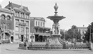
Pall Mall is a major thoroughfare in the centre of Bendigo, Victoria, Australia. It is one of the main streets of the Bendigo central business district and connects the Charing Cross intersection to the south-west with McCrae Street to the north-east at Howard Place, opposite Mundy Street. Pall Mall also forms a 500-metre section of the Midland Highway, one of Bendigo's main thoroughfares.

The Bendigo Valley is the region surrounding the city of Bendigo, Victoria, Australia located in North Central Victoria near the geographical centre of the state. The valley is approximately 150 kilometres (93 mi) north-west of Melbourne, the state capital. The city of Bendigo is located on the floor of, and is enclosed by, the Bendigo Valley which was formed over many millennia by the Bendigo Creek after which the valley is named. The Bendigo Creek forms a geographic spine through the city and suburbs of Bendigo. The valley is notable as a major tourist destination and is the location of one of the world's largest and longest-lived gold production areas.
