
The Yukon River is a major watercourse of northwestern North America. The river's source is in British Columbia, Canada, from which it flows through the Canadian Yukon Territory. The lower half of the river lies in the U.S. state of Alaska. The river is 3,190 kilometres (1,980 mi) long and empties into the Bering Sea at the Yukon–Kuskokwim Delta. The average flow is 6,430 m³/s (227,000 ft³/s). The total drainage area is 832,700 km² (321,500 mi²), of which 323,800 km² (126,300 mi²) is in Canada. The total area is more than 25% larger than Texas or Alberta.

The Canadian Rockies or Canadian Rocky Mountains comprise the Canadian segment of the North American Rocky Mountains. They are the eastern part of the Canadian Cordillera, which is a system of multiple ranges of mountains which runs from the Canadian Prairies to the Pacific Coast. The Canadian Rockies mountain system comprises the southeastern part of this system, lying between the Interior Plains of Alberta and Northeastern British Columbia on the east to the Rocky Mountain Trench of BC on the west. The southern end borders Idaho and Montana of the United States. In geographic terms the boundary is at the Canada/US border, but in geological terms it might be considered to be at Marias Pass in northern Montana. The northern end is at the Liard River in northern British Columbia.

The Bitterroot Range is a mountain range and a subrange of the Rocky Mountains that runs along the border of Montana and Idaho in the northwestern United States. The range spans an area of 24,223 square miles (62,740 km2) and is named after the bitterroot, a small pink flower that is the state flower of Montana.

The Liard River flows through Yukon, British Columbia and the Northwest Territories, Canada. Rising in the Saint Cyr Range of the Pelly Mountains in southeastern Yukon, it flows 1,115 kilometres (693 mi) southeast through British Columbia, marking the northern end of the Rocky Mountains and then curving northeast back into Yukon and Northwest Territories, draining into the Mackenzie River at Fort Simpson, Northwest Territories. The river drains approximately 277,100 square kilometres (107,000 sq mi) of boreal forest and muskeg.
There are several mountains called Gray Peak:

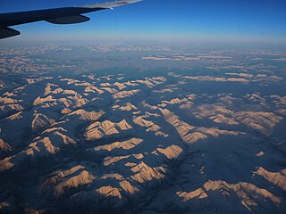
Yukon is in the northwestern corner of Canada and is bordered by Alaska and the Northwest Territories. The sparsely populated territory abounds with natural scenic beauty, with snowmelt lakes and perennial white-capped mountains, including many of Canada's highest mountains. The territory's climate is Arctic in the north, subarctic in the central region, between north of Whitehorse and Old Crow, and has a humid continental climate in the far south, south of Whitehorse and in areas close to the British Columbia border. The long sunshine hours in the short summer allow a profusion of flowers and fruit to blossom. Most of the territory is boreal forest, tundra being the main vegetation zone only in the extreme north and at high elevations.
The Little Salmon/Carmacks First Nation is a First Nation in the central Yukon Territory in Canada. Its original population centre was Little Salmon, Yukon, but most of its citizens live in Carmacks, Yukon. The language originally spoken by the Little Salmon/Carmacks First Nation people was Northern Tutchone. They call themselves Tagé Cho Hudän.

The Boundary Ranges, also known in the singular and as the Alaska Boundary Range, are the largest and most northerly subrange of the Coast Mountains. They begin at the Nass River, near the southern end of the Alaska Panhandle in the Canadian province of British Columbia and run to the Kelsall River, near the Chilkoot Pass, beyond which are the Alsek Ranges of the Saint Elias Mountains, and northwards into the Yukon Territory flanking the west side of the Yukon River drainage as far as Champagne Pass, north of which being the Yukon Ranges. To their east are the Skeena Mountains and Stikine Plateau of the Interior Mountains complex that lies northwest of the Interior Plateau; the immediately adjoining subregion of the Stikine Plateau is the Tahltan Highland. To their northeast is the Tagish Highland, which is a subregion of the Yukon Plateau. Both highlands are considered in some descriptions as included in the Coast Mountains. The Alexander Archipelago lies offshore and is entirely within Alaska.

Southwest Alaska is a region of the U.S. state of Alaska. The area is not exactly defined by any governmental administrative region(s); nor does it always have a clear geographic boundary.

The Tuya Range is a rmountain range in the Stikine Ranges of the Cassiar Mountains in the far north of the Canadian province of British Columbia, near its border with the Yukon Territory and to the southwest of Watson Lake, Yukon, which is the nearest major settlement.
The Yukon Ranges are a mountain range comprising the mountains in the southeastern part of the U.S. state of Alaska and most of the Yukon in Canada. Named after the Yukon, this range has area of 364,710 square kilometres (140,820 sq mi).

The Pelly Mountains are a mountain range in the Yukon, Canada. It has an area of 44014 km2 and is a subrange of the Yukon Ranges which in turn form part of the Pacific Coast Ranges.
Gray Peak is the unofficial name for the highest mountain of the Big Salmon Range in south-central Yukon, Canada, located 79 km (49 mi) north of Johnson's Crossing and 84 km (52 mi) south of Fox Mountain.
The Big Salmon River flows through the traditional territories of Teslin Tlingit, the Kaska Dena, and the Little Salmon Carmacks First Nations. This Big Salmon River is a tributary of the Yukon River The encampment of Big Salmon Village lies at the confluence of the Big Salmon and Yukon Rivers.
Solitary Mountain is a mountain in the Big Salmon Range of the Pelly Mountains in southcentral Yukon, Canada, located 49 km (30 mi) southwest of Faro. It is named for its isolation and is south of the Robert Campbell Highway.
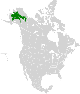
The Interior Alaska-Yukon lowland taiga ecoregion, in the Taiga and Boreal forests Biome, of far northern North America.

The Yukon River Basin is located between the Yukon Territory in Canada and Alaska, with a small portion in British Columbia. This basin is made up of 13 other individual basins that drain into the Yukon River and other adjoining rivers and tributaries. The Yukon River Basin is 330,000 square miles (850,000 km2) in area and 1,980 miles (3,190 km) in length. Many different geological features make up the basin, including several types of terrain, shrubland, and rivers.


