
Shangla District is a district in Malakand Division of Khyber Pakhtunkhwa, Pakistan. The district's headquarters are located at Alpuri, while the largest city and commercial center is Besham. The district was established in 1995, having previously been a subdivision of Swat District. The total area of the district is 1,586 square kilometers. Shangla comprises three subdivisions, Alpuri, Puran, Chakesar, Martung and Besham tehsils.

Namli Mera is a residential town and a mountainous rural area located in Abbottabad District, Khyber Pakhtunkhwa province, Pakistan.

On 26 December 2004, at 07:58:53 local time (UTC+7), a major earthquake with a magnitude of 9.1–9.3 struck with an epicentre off the west coast of northern Sumatra, Indonesia. The undersea megathrust earthquake, known by the scientific community as the Sumatra–Andaman earthquake, was caused by a rupture along the fault between the Burma Plate and the Indian Plate, and reached a Mercalli intensity up to IX in some areas.
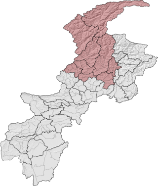
Malakand Division is an administrative division of Khyber Pakhtunkhwa province of Pakistan. CNIC code of Malakand Division is 15.

Battagram is a tribal district in Hazara Division of Khyber Pakhtunkhwa province in Pakistan. The headquarter is Battagram, which is about 75 km from Mansehra. It was part of historic Yaghistan before 1965.
Pirpiai is a town in the District of Nowshera in Khyber-Pakhtunkhwa, Pakistan. Its population is around 35,000. Pirpiai has a high literacy rate of 92%, compared with Pakistan's average literacy rate of 55%. The village is on GT Road, 8 km from Nowshera Cantonment towards Peshawar. Most of the villagers are working-folk, adding to the work-pool through government service, and self-employment. Substantial number of people from the village are working abroad and adding to national exchequer. The village is rich in producing educated and professional class like engineers, doctors, officers of armed forces, civil servants, professors and so on.

Library damage resulting from the 2004 Indian Ocean earthquake has been reported in six Asian countries. On December 26, the massive 2004 Indian Ocean earthquake struck off the northwest coast of the Indonesian island of Sumatra. The resulting tsunamis killed more than 180,000 people. In addition to the loss of human lives, cultural institutions were destroyed in several Asian nations. Libraries on the Eastern coast of Sri Lanka and the northern province of Aceh on Sumatra were most severely affected by the disaster.

An earthquake occurred at on 8 October 2005 in Azad Jammu and Kashmir, a territory under Pakistan. It was centred near the city of Muzaffarabad, and also affected nearby Balakot in Khyber Pakhtunkhwa and some areas of Jammu and Kashmir, India. It registered a moment magnitude of 7.6 and had a maximum Mercalli intensity of XI (Extreme). The earthquake was also felt in Afghanistan, Tajikistan, India and the Xinjiang region. The severity of the damage caused by the earthquake is attributed to severe upthrust. Over 86,000 people died, a similar number were injured, and millions were displaced. It is considered the deadliest earthquake in South Asia, surpassing the 1935 Quetta earthquake.

Alishing District is a district in Afghanistan, located 21 km from Mihtarlam, the provincial centre of Laghman Province. It has borders with Kabul and Kapisa provinces to the West, Dawlat Shah District to the North, Alingar District to the East and Mihtarlam District to the South. The district center is the village of Alishang, located on 34.7044°N 70.1539°E at 862 m altitude. There are 12 zones, each with around 12 to 14 villages located in the valleys and mountains. The Alishing river crosses the district and is the main source of irrigation.
Tehsil Birpani is a town and Union Council & Tehsil Birpani in Bagh District, Azad Kashmir, Pakistan.
Belian is a village in Pakistan. It is located in Oghi Tehsil and lies to the north east of the district capital Mansehra it lies in area affected by the 2005 Kashmir earthquake, it lies 60 km east of the epicentre of the 2005 Kashmir earthquake.
Aloch (آلوچ) is a town in Shangla District of Khyber Pakhtunkhwa included in Puran tehsil. Aloch is a commercial place for business community. Union Council Aloch is the largest Union Council of Tehsil Puran both on area and population basis. Aloch and Nimkalay comparatively have more facilities than the rest of Shangla District. The people at Aloch have almost access to all basic necessities of life and facilities at their doorsteps. They have a good hospital, Session Court, Police Setup, Schools and Colleges for both men and women, NADRA Office, Banks etc. within Aloch. Most of the inhabitants of Aloch belong to Abakhel branch of the subtribe Babozai of the major Pathan tribe Yousafzai. Haji Muhammad Zahid was Ex-Nazim of U.C Aloch.

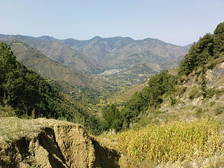
Martung, Mārtung or Martoong is a highland village and tehsil of Shangla District, Khyber Pakhtunkhwa, Pakistan included in Puran Subdivision. Central Martung (Koozkalai) is 982 m above sea level., Being hilly area, some parts of Martung are even more than 1800 m above mean sea level. Alogai is a place with scattered population in Martung having an altitude of 1641 meters. Martung is a green valley situated in the south-east of Shangla District, about 5 km north-west from River Indus. Major villages of the sub tehsil include Kabalgram, Pishlor, Titwalan, Koozkalai, Manzkalai, Shaga and Karindara.
Chakesar is a town and tehsil of the Shangla District in Khyber-Pakhtunkhwa province of Pakistan. It is situated about 6 km in the north-west on the right bank of the Indus River. Chakesar was given the status of Tehsil in 2017. The inhabitants live primarily on agricultural products.
Battagram Tehsil is an administrative subdivision (Tehsil) of the Battagram District in the Khyber Pakhtunkhwa province of Pakistan. It serves as the Tehsil headquarters and covers a total area of 300 square miles (780 km2). Battagram Tehsil merged into Pakistan as an administrative region before being raised to the status of a district in 1993. On October 8, 2005, a 7.6 magnitude earthquake in Kashmir badly affected the area.
Canadian Medical Assistance Teams (CMAT) is a Canadian grassroots, non profit disaster relief organization based in Brantford, Ontario, Canada. Through its medical relief and development projects, CMAT seeks to improve the health and welfare of families both in Canada and in developing countries around the world.
The 2011 Sindh floods was the highest-ever recorded rainfall between 11 August 2011, and 14 September 2011 in Sindh Province, Pakistan.

The October 2015 Hindu Kush earthquake was a magnitude 7.5 earthquake that struck South Asia on 26 October 2015, at 13:39 AFT with the epicenter 45 km north of Kuran wa Munjan, Afghanistan, at a depth of 231.0 km.

Mian Kalay is a town of Tehsil Alpurai in Shangla District of Khyber-Pakhtunkhwa province of Pakistan. It is the main village of Pirabd Union Council of Tehsil Alpurai and a commercial place for the business community. Mian Kalay is a town of the Pirabad Union Council (U.C) of Tehsil Alpurai, located at 34°54'15N 72°41'45E and lies in the area affected by the 2005 earthquake and 2010 Flood.