
Biliran, officially the Province of Biliran, is an island province in the Philippines located in the Eastern Visayas region. Biliran is one of the country's smallest and newest provinces. Formerly a sub-province of Leyte, it became an independent province in 1992.

Western Visayas is an administrative region in the Philippines, numerically designated as Region VI. It consists of six provinces and two highly urbanized cities. The regional center is Iloilo City. The region is dominated by the native speakers of four Visayan languages: Kinaray-a, Hiligaynon, Aklanon and Capiznon. The land area of the region is 20,794.18 km2 (8,028.68 sq mi), and with a population of 7,954,723 inhabitants, it is the most populous region in the Visayas.

Calayan, officially the Municipality of Calayan, is a 3rd class municipality in the province of Cagayan, Philippines. According to the 2020 census, it has a population of 17,410 people.

Tablas is the largest of the islands that comprise the province of Romblon in the Philippines. The name of the island was of Spanish origin. Before the colonization of the Philippines, Tablas was known as the Island of Osigan. At the time of contact with Westerners, Osigan had a population of two hundred and fifty people living in small villages. Wax was produced in this island.

Santa Elena, officially the Municipality of Santa Elena, is a 3rd class municipality in the province of Camarines Norte, Philippines. According to the 2020 census, it has a population of 43,582 people.

Santa Fe, officially the Municipality of Santa Fe, is a 5th class municipality in the province of Romblon, Philippines. According to the 2020 census, it has a population of 17,802 people.

Carles, officially the Municipality of Carles, is a 2nd class municipality in the province of Iloilo, Philippines. According to the 2020 census, it has a population of 72,637 people.

Dingle, officially the Municipality of Dingle, is a 3rd class municipality in the province of Iloilo, Philippines. According to the 2020 census, it has a population of 45,965 people.
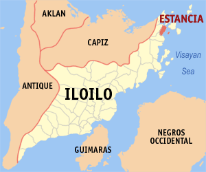
Estancia, officially the Municipality of Estancia, is a 2nd class municipality in the province of Iloilo, Philippines. According to the 2020 census, it has a population of 53,200 people.

Igbon Island is an island and barangay in northeastern Iloilo, Philippines. It is part of the municipality of Concepcion. According to the 2010 census, it has a population of 2,547. The island is moderately known in the Philippines for its scuba diving.
Bayas Island is a small island and barangay in northeastern Iloilo, Philippines. It is part of the municipality of Estancia. According to the 2010 census, it has a population of 2,316. The Island was titled to Filomena Reyes Aclaro and is now shared to the locals.
Malangabang is an island and barangay in northeastern Iloilo, Philippines. It is part of the municipality of Concepcion. According to the 2010 census, it has a population of 2,925. Fishing is the main source of income for the island's residents.
Manigonigo Island is an island in northeastern Iloilo, Philippines. It is one of fourteen islands politically administered by the municipality of Carles. The island's lighthouse was built by the Spanish during Spanish rule.

Nabunot is an island in northeastern Iloilo, Philippines. It is one of fourteen islands politically administered by the municipality of Carles.
Manlot is an uninhabited island-barangay in northeastern Iloilo, Philippines. It is one of fourteen islands politically administered by the municipality of Carles.
Himamylan is an uninhabited island in northeastern Iloilo, Philippines. It is one of fourteen islands politically administered by the municipality of Carles.
Calagnaan is an island in northeastern Iloilo, Philippines. It is one of fourteen islands politically administered by the municipality of Carles. The population is 890 in 208 households.
Balbagon is a teardrop-shaped island in northeastern Iloilo, Philippines. It is one of fourteen islands politically administered by the municipality of Carles. There is a small beach resort on the island.
Cabugao is a small, uninhabited island in northeastern Iloilo, Philippines. It is one of fourteen islands politically administered by the municipality of Carles. Along with Bantigui Island and Antonia Island, it is one of three minor southern islets in the Islas de Gigantes archipelago.
Talunan-an is a small island in northeastern Iloilo, Philippines. It is one of fourteen islands politically administered by the municipality of Carles.
