
Coonabarabran is a town in Warrumbungle Shire that sits on the divide between the Central West and North West Slopes regions of New South Wales, Australia. At the 2016 census, the town had a population of 2,537,and as of 2021, the population of Coonabarabran and its surrounding area is 3,477. Local and district residents refer to the town as 'Coona'. Coonabarabran is the gateway to the Warrumbungle National Park, Siding Spring Observatory and the Pilliga Forest.
Dunedoo is a village of 1,021 inhabitants situated within the Warrumbungle Shire of central western New South Wales, Australia. Dunedoo is well known to Australian travellers due to its distinctive name. The name is actually derived from a local Aboriginal word meaning "swan", which are commonly found in the area's lagoons.

Great Western Highway is a 202-kilometre-long (126 mi) state highway in New South Wales, Australia. From east to west, the highway links Sydney with Bathurst, on the state's Central Tablelands.

Castlereagh Highway is a 790-kilometre (490 mi) state highway located in New South Wales and Queensland, Australia. From north to south the highway traverses South West Queensland and the North West Slopes, Orana, and Central West regions of New South Wales.
Dirranbandi is a rural town and locality in the Shire of Balonne, Queensland, Australia. The locality is on the border of Queensland with New South Wales. In the 2021 census, the locality of Dirranbandi had a population of 610 people.

Carnarvon Highway is a state highway in Queensland and New South Wales, Australia, linking the township of Rolleston in Queensland's Central Highlands Region, via the town of St George, eventually to Moree in northern New South Wales. It is the main access road to the Carnarvon National Park, and serves as a strategic route to take B-doubles and other large vehicles to the Queensland ports north of Rockhampton.

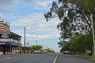
Binnaway is a small town located on the Castlereagh River in central western New South Wales near the larger centre of Coonabarabran, which is about 35 kilometres to the north. In 2016, the town had a population of 425 people. The road linking these two towns closely follows the meandering Castlereagh River. There are many pleasant areas to stop beside the road and on the river banks to have a picnic. Binnaway is also located near the similarly sized small town of Mendooran. Following local government amalgamation, the town is now located in the Warrumbungle Shire Council area which is headquartered at Coonabarabran.

Mendooran is a small town adjacent to the Castlereagh River in the Warrumbungle Shire of central western New South Wales, Australia. The town lies at an altitude of 271 metres above sea level, 348 kilometres west of Sydney, 75 kilometres from Dubbo and 71 kilometres southeast of Coonabarabran. At the 2021 census, Mendooran had a population of 275 people. The Castlereagh Highway also runs through the town, changing its name to Bandulla Street in the centre.

The City of Penrith is a local government area in the state of New South Wales, Australia. The seat of the city is located in Penrith, located about 50 kilometres (31 mi) west of Sydney's central business district. It occupies part of the traditional lands of the Darug people. First incorporated as a municipality on 12 May 1871, on 1 January 1949, the municipalities of Penrith, St Marys and Castlereagh and part of the Nepean Shire amalgamated to form a new Municipality of Penrith. Penrith was declared a City on 21 October 1959, and expanded westwards to include Emu Plains and Emu Heights, formerly part of the City of Blue Mountains, on 25 October 1963. As of the 2021 census the City of Penrith had an estimated population of 217,664.

Ilford is a village in New South Wales, Australia, beside the Crudine River within the Mid-Western Regional Council. It is located on the Castlereagh Highway, about 220 kilometres north-west of Sydney. At the 2016 census Ilford and the surrounding rural district had a population of 187, living in 65 private dwellings. The district also included 43 unoccupied private dwellings. Ilford was named after the English township of Ilford, from where early residents of the locality originated.

Castlereagh Street is a 1.6-kilometre-long (1 mi) major street located in the Sydney central business district in New South Wales, Australia. The street runs in a north-to-south, in a one way direction only.

Bylong Valley Way is a New South Wales regional road linking Golden Highway near Sandy Hollow to Castlereagh Highway near Ilford. It is named after the Bylong Valley, through which the road passes.

Trangie is a town in the Orana region of New South Wales, Australia. The town is on the Mitchell Highway 485 kilometres (301 mi) north west of the state capital Sydney. It is part of Narromine Shire local government area. At the 2016 census, Trangie had a population of 1,188. Trangie is on the Main Western railway line, New South Wales

Ben Bullen is a small mountain village in the Central West of New South Wales, Australia. It is located on the Castlereagh Highway (almost) halfway between the small towns of Cullen Bullen and Capertee. In the 2016 census, it recorded a population of 100 people. The place name Ben Bullen is derived from the local Aboriginal word meaning "high, quiet place".

Llangothlin is a rural locality with several houses, 11 kilometres (7 mi) north of Guyra on the Northern Tablelands in the New England region of New South Wales, Australia. Llangothlin was located in the Guyra Shire local government area until that council was amalgamated into the Armidale Regional Council on 12 May 2016.
Tallawang is an historical locality north of Gulgong in central western New South Wales, Australia. The place name is derived from an aboriginal word for "apple gum".
Kundabung is a locality on the North Coast of New South Wales, Australia.

Royalla is a rural locality on the border of New South Wales and the Australian Capital Territory. The area takes its name from the nearby Mount Rob Roy, and was originally a railway settlement on the Bombala railway line known as Rob Roy and changed to the current name in 1905. Modern Royalla is a large rural locality east of the Monaro Highway. The border with the ACT follows the western boundary of the easement of the former railway line to the east of the highway. The town was served by a railway station until 1975. The NSW part of Royalla had a population of 984 at the 2016 census.
Yarra is a locality in the Goulburn Mulwaree Council, New South Wales, Australia. It is located about 18 km southwest of Goulburn, 84 km northeast of Canberra and 213 km southwest of Sydney. It lies at the intersection of the Federal Highway and the Hume Highway. At the 2016 census, it had a population of 173. Yarra railway station was a station on the Main Southern railway line from 1875 to the 1970s. A small settlement grew up around the railway station and the Hume Highway, parts of which were demolished during road widening in the 1970s. It had a public school from 1869 to 1970, operating as a "half-time" school until 1873.
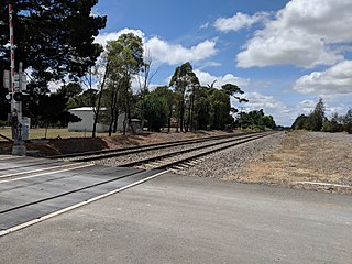
Running Stream is a locality in New South Wales, Australia. It is named after the creek flowing through the area. Running Stream is accessed on the Castlereagh Highway. The bus stop near the intersection with Mount Vincent Road is serviced several times a day by buses operated by NSW TrainLink departing from Lithgow railway station towards Gulgong, New South Wales.

