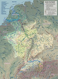
The Rhine is one of the major European rivers, which has its sources in Switzerland and flows in a mostly northerly direction through Germany and the Netherlands, emptying into the North Sea. The river begins in the Swiss canton of Graubünden in the southeastern Swiss Alps, forms part of the Swiss-Liechtenstein, Swiss-Austrian, Swiss-German and then the Franco-German border, then flows through the German Rhineland and the Netherlands and eventually empties into the North Sea.

The Upper Rhine is the section of the Rhine in the Upper Rhine Plain between Basel in Switzerland and Bingen in Germany. The river is marked by Rhine-kilometres 170 to 529.
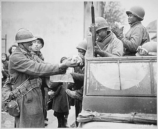
The Colmar Pocket was the area held in central Alsace, France, by the German Nineteenth Army from November 1944 to February 1945, against the U.S. 6th Army Group during World War II. It was formed when 6th AG liberated southern and northern Alsace and adjacent eastern Lorraine, but could not clear central Alsace. During Operation Nordwind in December 1944, the 19th Army attacked north out of the Pocket in support of other German forces attacking south from the Saar into northern Alsace. In late January and early February 1945, the French First Army cleared the Pocket of German forces.

Weil am Rhein is a German town and commune. It is on the east bank of the River Rhine, and close to the point at which the Swiss, French and German borders meet. It is the most southwesterly town in Germany and a suburb of the Swiss city Basel. Weil am Rhein is part of the "trinationale Agglomeration Basel" with about 830,000 inhabitants.

The High Rhine is the name used for the part of the Rhine that flows westbound from Lake Constance to Basel.

Birsfelden is a municipality in the district of Arlesheim in the canton of Basel-Country in Switzerland.
The Wiese is a river, 57.8 kilometres long, and a right-hand tributary of the Rhine in southwest Germany and northwest Switzerland.
Andelfingen District is one of the twelve districts of the German-speaking canton of Zurich, Switzerland.
The Bonn–Oberkassel train ferry was a German train ferry operated by the Rhenish Railway Company from 1870 to connect its right and left Rhine railways. It was the last of six train ferries to begin operations across the Rhine in Germany and the second to last to close.

The Birs is a 73-kilometre (45 mi) long river in Switzerland that flows through the Jura region and ends as a tributary to the Rhine between Basel and Birsfelden. It is the most important river of the Swiss Jura.

Germany is a country in west-central Europe, that stretches from the Alps, across the North European Plain to the North Sea and the Baltic Sea. Germany has the second largest population in Europe and is seventh largest in area. The territory of Germany covers 357,021 km2 (137,847 sq mi), consisting of 349,223 km2 (134,836 sq mi) of land and 7,798 km2 (3,011 sq mi) of waters.

The Jona is a river in the Swiss cantons of Zürich and St. Gallen.

The Glatt Valley is a region and a river valley in the canton of Zürich in Switzerland.

The Limmat Valley is a river valley and a region in the cantons of Zürich and Aargau in Switzerland.

The Bruckgut estate lies at the foot of the hill, below the village centre of Münchenstein, in the canton of Basel-Country in Switzerland.
The Bruckgut farming estate is listed as a heritage site of national significance.

The Basel tramway network is a network of tramways forming part of the public transport system in Basel, Switzerland, and the Swiss part of its agglomeration. It consists of 13 lines. Due to its longevity, it is part of Basel's heritage and, alongside the Basel Minster, is one of the symbols of the city.

At the Battle of Schliengen, the French Army of the Rhine and Moselle under the command of Jean-Victor Moreau and the Austrian army under the command of Archduke Charles of Austria both claimed victories. The village of Schliengen lies in the present-day Kreis Lörrach close to the border of present-day Baden-Württemberg (Germany), the Haut-Rhin (France), and the Canton of Basel-Stadt (Switzerland).

The Fortified Sector of Colmar was the French military organization that in 1940 controlled the section of the French frontier with Germany in the vicinity of Colmar. The fortifications were built as part of France's Maginot Line defensive strategy, but the sector lacks the large interconnected fortifications found along France's land border with Germany. The sector's principal defense was the Rhine itself, which could be crossed only by boat or by seizing a bridge crossing. The sector's fortifications chiefly took the form of casemates and blockhouses. The SF Colmar was flanked to the north by the Fortified Sector of the Lower Rhine to the north and the Fortified Sector of Mulhouse to the south. The Colmar sector was directly attacked by German forces on 15 June 1940, capturing or destroying most of the fortifications in the sector in three days.

The Seerhein is a river about four kilometres long, in the basin of Lake Constance. It is the outflow of the Upper Lake Constance and the main tributary of the Lower Lake Constance. The water level of the lower lake is about 30 cm below the level of the Upper Lake. It is considered part of the Rhine, which flows into Lake Constance as the Alpine Rhine and flows out of the Lake as the High Rhine. The Seerhein arose after the last Ice Age. Some time after this period, the water level of Lake Constance gradually dropped by about ten metres and the shallow parts fell dry. Some parts of the Seerhein still have a character a bit like a lake.

Holzbrücke Bad Säckingen or Säckingerbrücke is a bridge over the Rhine. It connects the German city of Bad Säckingen with the village Stein in Switzerland. The covered bridge spans 203.7 metres (668 ft) over the Hochrhein and is the longest roofed wooden bridge of Europe. The bridge is listed as a national registered monument in Switzerland.
