Bischofswiesen

Last updated
Bischofswiesen
Stanggass.JPG
Bischofswiesen
Wappen von Bischofswiesen.svg
Coat of arms
Location of Bischofswiesen within Berchtesgadener Land district
Bischofswiesen in BGL.png
Germany adm location map.svg
Red pog.svg
Bischofswiesen
Bavaria location map.svg
Red pog.svg
Bischofswiesen
Coordinates: 47°38′58″N12°57′50″E / 47.64944°N 12.96389°E / 47.64944; 12.96389 Coordinates: 47°38′58″N12°57′50″E / 47.64944°N 12.96389°E / 47.64944; 12.96389
Country Germany
State Bavaria
Admin. region Oberbayern
District Berchtesgadener Land
Government
   Mayor (202026) Thomas Weber [1] (CSU)
Area
  Total34.46 km2 (13.31 sq mi)
Elevation
610 m (2,000 ft)
Population
 (2020-12-31) [2]
  Total7,280
  Density210/km2 (550/sq mi)
Time zone UTC+01:00 (CET)
  Summer (DST) UTC+02:00 (CEST)
Postal codes
83483
Dialling codes 08652
Vehicle registration BGL
Website gemeinde.bischofswiesen.de

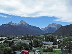
Bischofswiesen is a municipality in the district of Berchtesgadener Land in Bavaria in Germany.

Related Research Articles

Burgkirchen an der Alz Place in Bavaria, Germany

Burgkirchen an der Alz is a municipality in the district of Altötting, in Bavaria, Germany. It is situated on the river Alz, 8 km west of Burghausen.

Winhöring Place in Bavaria, Germany

Winhöring is a municipality in the district of Altötting in Bavaria in Germany. It lies on the river Inn.

Mönchsroth Place in Bavaria, Germany

Mönchsroth is a municipality in the district of Ansbach in Bavaria in Germany.

Gessertshausen Place in Bavaria, Germany

Gessertshausen is a municipality in the district of Augsburg in Bavaria in Germany. It lies on the Schmutter River.

Bissingen, Bavaria Place in Bavaria, Germany

Bissingen is a municipality in the district of Dillingen in Bavaria in Germany.

Hausen, Upper Franconia Place in Bavaria, Germany

Hausen is a municipality in the district of Forchheim in Bavaria in Germany.

Sand am Main Place in Bavaria, Germany

Sand is a municipality in the district of Haßberge in Bavaria in Germany. It lies on the river Main.

Seubersdorf Place in Bavaria, Germany

Seubersdorf is a municipality in the district of Neumarkt in Bavaria in Germany.

Germaringen Place in Bavaria, Germany

Germaringen is a municipality in the district of Ostallgäu in Bavaria in Germany.

Hopferau Place in Bavaria, Germany

Hopferau is a municipality in the district of Ostallgäu in Bavaria in Germany.

Bodenwöhr Place in Bavaria, Germany

Bodenwöhr is a municipality in the district of Schwandorf in Bavaria, Germany.

Wackersdorf Place in Bavaria, Germany

Wackersdorf is a municipality in the district of Schwandorf in Bavaria, Germany. It is famous for playing host to rounds of the CIK-FIA Karting European Championship.

Pfaffenhausen Place in Bavaria, Germany

Pfaffenhausen is a municipality in the district of Unterallgäu in Bavaria, Germany. The town is seat of a municipal association with Breitenbrunn, Swabia, Oberrieden, Bavaria and Salgen.

Güntersleben Place in Bavaria, Germany

Güntersleben is a municipality in the district of Würzburg in Bavaria in Germany.

Buxheim, Swabia Place in Bavaria, Germany

Buxheim is a municipality in the district of Unterallgäu in Bavaria, Germany.

Hawangen Place in Bavaria, Germany

Hawangen is a municipality in the district of Unterallgäu in Bavaria, Germany, with about 1254 inhabitants. Hawangen is situated 5 km (3 mi) east of Memmingen. The town has a municipal association with Ottobeuren.

Burggen Place in Bavaria, Germany

Burggen is a municipality in the Weilheim-Schongau district, in Bavaria, Germany.

Geroldshausen Place in Bavaria, Germany

Geroldshausen is a municipality in the district of Würzburg in Bavaria, Germany.

Tauberrettersheim Place in Bavaria, Germany

Tauberrettersheim is a municipality in the district of Würzburg in Bavaria, Germany. It lies on the river Tauber.

Winterhausen Place in Bavaria, Germany

Winterhausen is a municipality in the district of Würzburg in Bavaria, Germany.

References

  1. Liste der ersten Bürgermeister/Oberbürgermeister in kreisangehörigen Gemeinden, Bayerisches Landesamt für Statistik, accessed 19 July 2021.
  2. "Tabellenblatt "Daten 2", Statistischer Bericht A1200C 202041 Einwohnerzahlen der Gemeinden, Kreise und Regierungsbezirke". Bayerisches Landesamt für Statistik und Datenverarbeitung (in German). June 2021.