Schneizlreuth

Last updated
Schneizlreuth
WBadA StVinzenz.jpg
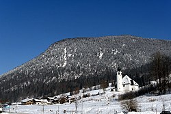
Saint Vincent Church in Weißbach an der Alpenstraße, municipal part of Schneizlreuth
DEU Schneizlreuth COA.svg
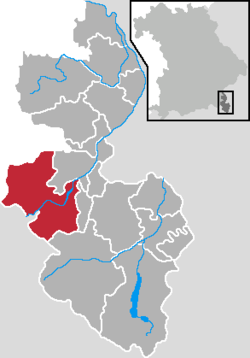
Location of Schneizlreuth within Berchtesgadener Land district
Schneizlreuth in BGL.pngEck (unincorporated area)Schellenberger ForstAngerLaufen
Germany adm location map.svg
Red pog.svg
Schneizlreuth
Bavaria location map.svg
Red pog.svg
Schneizlreuth
Coordinates: 47°41′N12°48′E / 47.683°N 12.800°E / 47.683; 12.800
Country Germany
State Bavaria
Admin. region Oberbayern
District Berchtesgadener Land
Government
   Mayor (202026) Wolfgang Simon [1] (FW)
Area
  Total
107.28 km2 (41.42 sq mi)
Elevation
511 m (1,677 ft)
Population
 (2024-12-31) [2]
  Total
1,375
  Density12.82/km2 (33.20/sq mi)
Time zone UTC+01:00 (CET)
  Summer (DST) UTC+02:00 (CEST)
Postal codes
83458
Dialling codes 08651, 08665 (Ortsteile Weißbach und Jochberg)
Vehicle registration BGL
Website www.schneizlreuth.de

Schneizlreuth is a municipality in the district of Berchtesgadener Land in Bavaria in Germany.

Contents

History

In 1285, an estate in the area was called Schnaezenreut. This is the earliest the town's name can be traced.

The municipality of Schneizlreuth was created on 1 July 1909 by merging the municipalities of Jettenberg (with the districts Oberjettenberg and Unterjettenberg) and Ristfeucht (including Schneizlreuth, then a hamlet). On 5 May 1945, the last battles of World War II that were held in Bavaria took place in Schneizlreuth.

On 1 January 1984, the northern, larger part of the unincorporated area Jette Forst was incorporated into Schneizlreuth, adding an area of 2279.77 hectares. The smaller southern portion with 683.49 acres joined the neighboring village of Ramsau. On 1 January 2011, the eastern portion of Forest St. Zeno (966.50 hectares) was incorporated into Schneizlreuth. The rest of the area, 290.10 acres, was annexed to Bad Reichenhall. Both of these uninhabited, formerly unincorporated areas continue under their former names as districts within the Schneizlreuth municipality.

Famous citizens

References

  1. Liste der ersten Bürgermeister/Oberbürgermeister in kreisangehörigen Gemeinden, Bayerisches Landesamt für Statistik, accessed 19 July 2021.
  2. "Gemeinden, Kreise und Regierungsbezirke in Bayern, Einwohnerzahlen am 31. Dezember 2024; Basis Zensus 2022" [Municipalities, counties, and administrative districts in Bavaria; Based on the 2022 Census](CSV) (in German). Bayerisches Landesamt für Statistik.