Bishop's (ward)

Last updated

Bishop's
electoral ward
Coordinates: 51°30′00″N0°06′50″W / 51.500°N 0.114°W / 51.500; -0.114
Country United Kingdom
Constituent country England
Region London
County Greater London
London borough Lambeth

Bishop's ward was an administrative division of the London Borough of Lambeth, United Kingdom, from 1965 to 2022

Contents

It was located in the north of the borough, bounded by the river Thames, and contained many well known London sites including the Southbank Centre, the London Eye, the Old and New Vic theatres, County Hall and Lambeth Palace. It also contained Waterloo station and St Thomas Hospital.

Bishop's ward was located in the Vauxhall parliamentary constituency and is one of four wards in the borough's north Lambeth division.

The Lambeth Council State of the Borough 2014 report found that Bishop's was the least residential ward of the borough. [1] It had the lowest ward population (10,600), with a low proportion of children – over 80% of residents are working age, with many born outside UK. It has the highest number of jobs and the highest employment per head of resident working age population. Health outcomes, such as life expectancy and childhood obesity are typical of the borough. It had the highest proportion of Asian residents in the borough.

Although the riverside areas are affluent, household income in most of the rest of the ward was comparable with the borough as a whole. Housing tenure was similar to the borough as a whole – 21% home owners, 42% Social rented, 34% private rented. It had the highest proportion of flats, and house prices are high - 30% of dwellings are in the higher council tax (property tax) bands F, G or H. Bishop͛s had the highest ward crime rate figures as of 2013, especially violence against the person and theft and handling – this is associated with large numbers of people in the ward at Waterloo station and the South Bank.

Lambeth Council elections

Bishop's (ward)
Bishop's ward boundaries from 2002 to 2022

2018 election

2018 Lambeth London Borough Council election: Bishop's (3)
PartyCandidateVotes%±%
Labour Jen Moseley* 1,126 15.8 +9.2
Labour Kevin Craig* 1,094 15.4
Labour Ibrahim Dogus 1,090 15.3
Liberal Democrats Audrey Eager71310.0-3.8
Liberal Democrats Adrian Hyyrylainen-Trett6919.7
Liberal Democrats Charley Hasted6068.5
Conservative James Bellis3114.4+1.9
Green Michael Armstrong2924.1+0.1
Conservative Glyn Chambers2864.0
Green James Wallace2533.6
Conservative Peter Wilde2433.4
Green Gay Lee1892.7
UKIP Elizabeth Jones861.2-5.2
UKIP Gavin Gibbs721.0
UKIP David Poulden691.0
Labour hold Swing
Labour hold Swing
Labour hold Swing

2014 election

2014 Lambeth London Borough Council election: Bishop's (3)
PartyCandidateVotes%±%
Labour Jennifer Moseley 1,106 37.3
Labour Kevin Craig 1,061
Labour Ben Kind 975
Liberal Democrats Diana Braithwaite*94932.0
Liberal Democrats Peter Truesdale*939
Liberal Democrats Mathew Hanney777
Green Sam Brightbart30410.3
Green Clive Croft295
Conservative David Frost2929.9
Conservative Edward Harrison291
Conservative Lee Rotherham284
Green Bart Gorissen272
UKIP Andrew Hayes2488.4
Trade_Unionist_and_Socialist_Coalition El Morris632.1
Total votes7,857 72.1
Labour gain from Liberal Democrats Swing

2010 election

2010 Lambeth London Borough Council election: Bishop's (3)
PartyCandidateVotes%±%
Liberal Democrats Diana Braithwaite * 1,676
Liberal Democrats Peter Truesdale * 1,641
Liberal Democrats Gavin Dodsworth * 1,483
Labour Jennifer Moseley1,307
Labour Kevin Craig1,256
Labour Rodney Reid1,067
Conservative Edward Blain751
Conservative Edward Jones667
Conservative Rickard Jonsson649
Green Colin Kavanagh339
Green James Wallace288
Green Jonathan Stone-Fewings197
Total votes11,321
Liberal Democrats hold Swing

2006 election

2006 Lambeth London Borough Council election: Bishop's (3)
PartyCandidateVotes%±%
Liberal Democrats Peter Truesdale * 1,090
Liberal Democrats Diana Braithwaite 1,020
Liberal Democrats Gavin Dodsworth 869
Labour Richard Bridge485
Labour Rodney Reid427
Labour Kevin Craig399
Green James Wallace381
Conservative Carl Gibson289
Conservative Jeremy Fox285
Local Education Action by Parents Christine Holt249
Conservative Gareth Streeter236
Total votes5,730
Liberal Democrats hold Swing

2002 election

2002 Lambeth London Borough Council election: Bishop's (3)
PartyCandidateVotes%±%
Liberal Democrats Peter Truesdale 1,123
Liberal Democrats Charlotte Parry 1,039
Liberal Democrats Clive Parry 994
Labour Lorna Campbell622
Labour Madge McGhie506
Labour Lee Seaman488
Green Simon Williams166
Conservative Audrey Blaine125
Conservative Caroline King121
Conservative Judith Pattman106
Socialist Alliance Veronica Planton80
Turnout 5,37027.3
Liberal Democrats hold Swing
Liberal Democrats gain from Labour Swing

1998 election

1994 election

1990 election

1986 election

1982 election

1978 election

1974 election

1971 election

1968 election

1964 election

Related Research Articles

<span class="mw-page-title-main">London Borough of Islington</span> London borough in United Kingdom

The London Borough of Islington is a London borough which forms part of Inner London, England. Islington has an estimated population of 215,667. It was formed in 1965 under the London Government Act 1963, which simultaneously abolished the metropolitan boroughs of Islington and Finsbury.

<span class="mw-page-title-main">London Borough of Southwark</span> London borough in United Kingdom

The London Borough of Southwark in South London forms part of Inner London and is connected by bridges across the River Thames to the City of London and London Borough of Tower Hamlets. It was created in 1965 when three smaller council areas amalgamated under the London Government Act 1963. All districts of the area are within the London postal district. It is governed by Southwark London Borough Council.

<span class="mw-page-title-main">London Borough of Ealing</span> London borough in United Kingdom

The London Borough of Ealing is a London borough in West London, England. It comprises seven major towns: Acton (W3), Ealing, Greenford (UB6), Hanwell (W7), Northolt (UB5), Perivale (UB6) and Southall. With a population of 367,100 inhabitants, it is the third most populous London borough.

<span class="mw-page-title-main">Stockwell</span> Human settlement in England

Stockwell is a district located in South West London, part of the London Borough of Lambeth, England. It is situated 2.4 miles (3.9 km) south of Charing Cross.

<span class="mw-page-title-main">Vauxhall</span> District of London

Vauxhall is a district in South West London, part of the London Borough of Lambeth, England. Vauxhall was part of Surrey until 1889 when the County of London was created. Named after a medieval manor, "Fox Hall", it became well known for the Vauxhall Pleasure Gardens.

<span class="mw-page-title-main">London Borough of Brent</span> London borough in United Kingdom

Brent is a borough in north-west London. It is known for landmarks such as Wembley Stadium, the Swaminarayan Temple and the Kiln Theatre. It also contains the Welsh Harp reservoir and the Park Royal commercial estate. The local authority is Brent London Borough Council.

<span class="mw-page-title-main">London Borough of Redbridge</span> London borough in United Kingdom

The London Borough of Redbridge is a London borough established in 1965.

<span class="mw-page-title-main">London Borough of Lambeth</span> London borough in United Kingdom

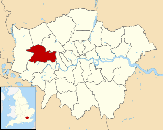
Lambeth is a London borough in South London, England, which forms part of Inner London. Its name was recorded in 1062 as Lambehitha and in 1255 as Lambeth. The geographical centre of London is at Frazier Street near Lambeth North tube station, though nearby Charing Cross on the other side of the Thames in the City of Westminster is traditionally considered the centre of London.

<span class="mw-page-title-main">East Horsley</span> Village in Surrey, England

East Horsley is a village and civil parish in Surrey, England, 21 miles southwest of London, on the A246 between Leatherhead and Guildford. Horsley and Effingham Junction railway stations are on the New Guildford line to London Waterloo. The two-halves of ancient Horsley are similar in having substantial woodland and some chalky lower slopes, in the south, of the North Downs.

<span class="mw-page-title-main">South Bank</span> Commercial and entertainment district in London

The South Bank is an entertainment and commercial district in central London, England on the south bank of the River Thames opposite the City of Westminster. It forms a narrow strip of riverside land within the London Borough of Lambeth and the London Borough of Southwark,. As such, the South Bank may be regarded as somewhat akin to the riverside part of an area known previously as Lambeth Marsh and North Lambeth.

<span class="mw-page-title-main">Lambeth</span> Human settlement in England

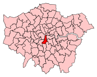
Lambeth is a district in South London, England, in the London Borough of Lambeth. Lambeth was an ancient parish in the county of Surrey. It is situated 1 mile (1.6 km) south of Charing Cross. The population of the London Borough of Lambeth was 303,086 in 2011. The area experienced some slight growth in the medieval period as part of the manor of Lambeth Palace. By the Victorian era the area had seen significant development as London expanded, with dense industrial, commercial and residential buildings located adjacent to one another. The changes brought by World War II altered much of the fabric of Lambeth. Subsequent development in the late 20th and early 21st centuries has seen an increase in the number of high-rise buildings. The area is home to the International Maritime Organization. Lambeth is home to one of the largest Portuguese-speaking communities in the UK, and Portuguese is the second most commonly spoken language in Lambeth after English.

<span class="mw-page-title-main">Metropolitan Borough of Lambeth</span> Metropolitan borough of England

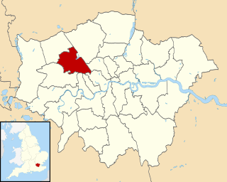
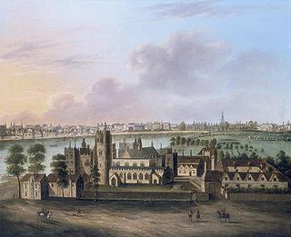
Lambeth was a civil parish and metropolitan borough in south London, England. It was an ancient parish in the county of Surrey. The parish was included in the area of responsibility of the Metropolitan Board of Works in 1855 and became part of the County of London in 1889. The parish of Lambeth became a metropolitan borough in 1900, following the London Government Act 1899, with the parish vestry replaced by a borough council.

<span class="mw-page-title-main">Metropolitan Borough of Oldham</span> Borough of Greater Manchester, England

The Metropolitan Borough of Oldham is a metropolitan borough of Greater Manchester in England. It is named after its largest town, Oldham, The borough had a population of 237,628 making it the seventh-largest district by population in Greater Manchester. The borough spans 55 square miles (142 km2).

<span class="mw-page-title-main">Streatham (UK Parliament constituency)</span> Parliamentary constituency in the United Kingdom, 1918 onwards

Streatham is a constituency represented in the House of Commons of the UK Parliament since 2019 by Bell Ribeiro-Addy of the Labour Party.

<span class="mw-page-title-main">Vauxhall (UK Parliament constituency)</span> Parliamentary constituency in the United Kingdom, 1950 onwards

Vauxhall is a constituency represented in the House of Commons by Florence Eshalomi of Labour Co-op since her election in 2019.

Larkhall was a ward in the London Borough of Lambeth, from 1965 to 2022.

<span class="mw-page-title-main">Lambeth Marsh</span>

Lambeth Marsh is one of the oldest settlements on the South Bank of London, England.

<span class="mw-page-title-main">Vassall (ward)</span>

Vassall ward was an administrative division of the London Borough of Lambeth, United Kingdom, from 1965 to 2022. It was located in the north of borough bordering Southwark, in the SW9 and SE5 postcode area. The ward was named after Henry Vassall-Fox, 3rd Baron Holland who was responsible for the first building development in the area in the 1820s.

Coldharbour ward was an administrative division of the London Borough of Lambeth from 2002 to 2022. It is located in Brixton.

Knight's Hill ward is an administrative division of the London Borough of Lambeth, United Kingdom, roughly covering the West Norwood area.

References