Rzerzęczyce is a village in the administrative district of Gmina Kłomnice, within Częstochowa County, Silesian Voivodeship, in southern Poland. It lies approximately 6 kilometres (4 mi) south-west of Kłomnice, 17 km (11 mi) north-east of Częstochowa, and 74 km (46 mi) north of the regional capital Katowice. From 1975 to 1998 it was in Częstochowa Voivodeship.

Rakovo is a village and municipality in Martin District in the Žilina Region of northern Slovakia.

Kék is a village in Szabolcs-Szatmár-Bereg county, in the Northern Great Plain region of eastern Hungary. The village has nearly 2,000 inhabitants.
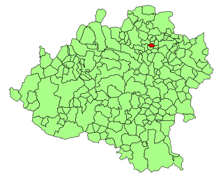
Aldealseñor is a municipality located in the province of Soria, Castile and León, Spain. According to the 2004 census (INE), the municipality has a population of 46 inhabitants.
Stupniki is a village in the administrative district of Gmina Bielsk Podlaski, within Bielsk County, Podlaskie Voivodeship, in north-eastern Poland. It lies approximately 16 kilometres (10 mi) north-east of Bielsk Podlaski and 28 km (17 mi) south of the regional capital Białystok.
Ługiele is a village in the administrative district of Gmina Wiżajny, within Suwałki County, Podlaskie Voivodeship, in north-eastern Poland, close to the border with Lithuania. It lies approximately 9 kilometres (6 mi) south of Wiżajny, 27 km (17 mi) north of Suwałki, and 135 km (84 mi) north of the regional capital Białystok.
Poplin is a village in the administrative district of Gmina Wiżajny, within Suwałki County, Podlaskie Voivodeship, in north-eastern Poland, close to the border with Lithuania. It lies approximately 9 kilometres (6 mi) south of Wiżajny, 27 km (17 mi) north of Suwałki, and 135 km (84 mi) north of the regional capital Białystok.

Naburlu is a village in the Khachmaz Rayon of Azerbaijan.
Wola Wieruszycka is a village in the administrative district of Gmina Łapanów, within Bochnia County, Lesser Poland Voivodeship, in southern Poland. It lies approximately 3 kilometres (2 mi) north-east of Łapanów, 14 km (9 mi) south-west of Bochnia, and 34 km (21 mi) south-east of the regional capital Kraków.
Sulmice is a village in the administrative district of Gmina Skierbieszów, within Zamość County, Lublin Voivodeship, in eastern Poland. It lies approximately 6 kilometres (4 mi) north-west of Skierbieszów, 19 km (12 mi) north of Zamość, and 67 km (42 mi) south-east of the regional capital Lublin.
Załuzie is a village in the administrative district of Gmina Różan, within Maków County, Masovian Voivodeship, in east-central Poland. It lies approximately 5 kilometres (3 mi) west of Różan, 15 km (9 mi) east of Maków Mazowiecki, and 78 km (48 mi) north of Warsaw.
Lələdulan is a village in the municipality of Aran in the Lerik Rayon of Azerbaijan.
Nangalasso is a small town and commune in the Cercle of Kolondieba in the Sikasso Region of southern Mali. In 1998 the commune had a population of 7,887.
Młynowo is a village in the administrative district of Gmina Mrągowo, within Mrągowo County, Warmian-Masurian Voivodeship, in northern Poland. It lies approximately 3 kilometres (2 mi) north-east of Mrągowo and 55 km (34 mi) east of the regional capital Olsztyn.

Souňov is a village and municipality in Kutná Hora District in the Central Bohemian Region of the Czech Republic.
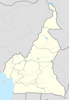
Bibemi is a town and commune in Cameroon.
Roovere is a village in Väätsa Parish, Järva County in central Estonia.

Vărvăreuca is a commune in Floreşti District, Moldova. It is composed of two villages, Stîrceni and Vărvăreuca.
Kundaragi is a village in Bilagi taluk Bagalkot district in Karnataka, India. beside the river ghataphrabha.
Koke, Estonia is a village in Kastre Parish, Tartu County in eastern Estonia.