Bjerke (borough)

Last updated
Bydel Bjerke
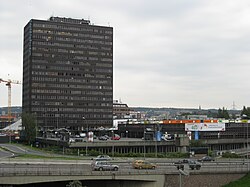
Okern Oslo.JPG
Oslo komm.svg
Oslo bjerke.png
Country Norway
City Oslo
District Grorud Valley
Area
  Total7.72 km2 (2.98 sq mi)
Population
 (2020 [1] )
  Total33,422
  Density4,329/km2 (11,210/sq mi)
Time zone UTC+1 (CET)
  Summer (DST) UTC+2 (CEST)
ISO 3166 code NO-030109
Website bbj.oslo.kommune.no

Bjerke is a borough of the city of Oslo, Norway.

The most densely populated residential areas, including the high-rise apartment blocks of Linderud, are located along Trondheimsveien (Norwegian National Road 4). The shopping centre at Linderud is also home to the borough council's administrative headquarters. The northern areas of the borough are bordered by the vast woodlands of Oslomarka. Bjerke Upper Secondary School is located here.

Contents

Districts

Politics

As a borough of Oslo, Bjerke is governed by the city council of Oslo as well as its own borough council. The council leader is Lars Fuglesang from the Labour Party and the deputy leader is Hans Husum, of the Socialist Left Party. The Labour Party has the most seats. The 15 seats are distributed among the following political parties for the 2019-2023 term: [2]

Transportation

Trondheimsveien is the main road that runs through the borough. Multiple busses on the local- and the regional bus network serve the area and allow for commuters to travel into the city-centre of Oslo. Multiple metro stations on the Grorud Line, also are in Bjerke and serve a similar purpose. [3] A tram extension of the Sinsen Line has been proposed from the current stop at Sinsenkrysset and run all the way to Tonsenhagen. [4]

This is Vollebekk metro station. This is located within Bjerke. Vollebekk stasjon.JPG
This is Vollebekk metro station. This is located within Bjerke.

Related Research Articles

<span class="mw-page-title-main">Oslo</span> Capital of Norway

Oslo is the capital and most populous city of Norway. It constitutes both a county and a municipality. The municipality of Oslo had a population of 709,037 in 2022, while the city's greater urban area had a population of 1,064,235 in 2022, and the metropolitan area had an estimated population of 1,546,706 in 2021.

<span class="mw-page-title-main">St. Hanshaugen</span> Borough of Oslo, Norway

St. Hanshaugen is a borough of the city of Oslo, Norway.

<span class="mw-page-title-main">Sagene</span> Borough in Norway

Sagene is a borough of the city of Oslo, Norway. The area became part of the city of Oslo in 1859. The name Sagene itself is the plural of the Norwegian word for "saw", reflecting all the old industrial mechanical saws powered by the river Akerselva in this area in the 19th and early 20th centuries.

<span class="mw-page-title-main">Grünerløkka</span> Borough in Norway

Grünerløkka is a borough but also a neighborhood of the city of Oslo, Norway. Grünerløkka became part of the city of Oslo in 1858. Grünerløkka was traditionally a working class district; since the late 20th century the area has increasingly undergone gentrification. Especially in the core neighborhood of Grünerløkka, property prices tend to be higher than what is typical of other Oslo East End boroughs.

<span class="mw-page-title-main">Ullern</span> Borough in Norway

Ullern is a borough of the city of Oslo, Norway.

<span class="mw-page-title-main">Gamle Oslo</span> Borough in Norway

Gamle Oslo is a borough of the city of Oslo, Norway. The name means "Old Oslo", and the district contains Old Town.

<span class="mw-page-title-main">Frogner</span> Borough in Oslo, Norway

Frogner is a residential and retail borough in the West End of Oslo, Norway, with a population of 59,269 as of 2020. In addition to the original Frogner, the borough incorporates Bygdøy, Uranienborg and Majorstuen. The borough is named after Frogner Manor, and includes Frogner Park. The borough has the highest real estate prices in Norway.

<span class="mw-page-title-main">Grorud</span> Borough in Norway

Grorud is a borough of the city of Oslo, Norway. The borough contains the Ammerud, Grorud, Kalbakken, Rødtvet, Nordtvet and Romsås areas. To the north of the borough is the forest of Lillomarka. The borough is the smallest in Oslo, with fewer than 30 000 inhabitants.

<span class="mw-page-title-main">Vestre Aker</span> Borough in Norway

Vestre Aker is a borough of the city of Oslo, Norway. It has a population of 50,157 as of 2020.

<span class="mw-page-title-main">Nordre Aker</span> Borough in Norway

Nordre Aker is a borough of the city of Oslo, Norway.

<span class="mw-page-title-main">Alna</span> Borough in Norway

Alna is a borough of the city of Oslo, Norway. It is named after the River Alna, which flows through it.

<span class="mw-page-title-main">Linderud (station)</span> Oslo metro station

Linderud is a station on Grorud Line of the Oslo Metro located between Vollebekk and Veitvet in Norway. The station is located in the Bjerke borough. Linderud is a residential area, with several tall apartment buildings. The area has a modern shopping centre, located 400 meters (1,300 ft) from the station.

Tonsenhagen is a neighborhood in the borough of Bjerke in northeast Oslo, Norway. Built in the 1950s, it was one of the early new suburbs within Oslo.

<span class="mw-page-title-main">Grorud Valley</span>

The Grorud Valley is a valley and urban area or suburb in the northeastern part of Oslo, the capital of Norway. Four of Oslo's boroughs lie within the Grorud Valley; Bjerke to the west, Alna to the south, Grorud to the north, and Stovner to the east. The name Groruddalen has been in use at least since the mid-19th century. The current use of the name Groruddalen was coined in 1960 to describe the area covered by the local newspaper Akers Avis Groruddalen, until then named Akers avis. Before 1960, this area was known as Akersdalen, whilst the name Groruddalen was user for the river valley from lake Alnsjøen along Alna River to Bryn.

<span class="mw-page-title-main">Sinsen Line</span>

The Sinsen Line is part of the Oslo Tramway on the east side of the city. Most of the line is served by line 17, although the northernmost tip (Grefsen–Torshov) is served by line 18 which otherwise runs on the Grünerløkka–Torshov Line. Both services use SL95 articulated trams.

<span class="mw-page-title-main">Vika Line</span> Railway line in Vika, Oslo

The Vika Line is a light rail section of the Oslo Tramway in Oslo, Norway. It runs between Wessels plass, through the neighborhood of Vika and Aker Brygge, before arriving at Solli. The section is served by SL79 trams on line 12. The line is owned by the municipal company Kollektivtransportproduksjon, and operated by its subsidiary Oslo Sporvognsdrift.

<span class="mw-page-title-main">Lillomarka</span> Forest in Norway

Lillomarka is an area located to the northeast of Oslo, Norway. It is a part of Oslomarka and serves as a popular recreational area. Lillomarka is bordered by Maridalen and Nordmarka in the west, Nittedal and Gjelleråsen in the east, the suburbs Bjerke and Grorud in the south and the Gjøvik rail line and Movatn in the north.

<span class="mw-page-title-main">Government of Oslo</span>

The Politics and government of Oslo reflects that Oslo is the capital of Norway, and as such is the seat of Norway's national government. Most government offices, including that of the Prime Minister, are gathered at Regjeringskvartalet, a cluster of buildings close to the national parliament—the Storting.

<span class="mw-page-title-main">Veitvet</span> Neighborhood in Oslo, Norway

Veitvet is a neighborhood in the Bjerke borough of Oslo, Norway. The area borders to Linderud, Tonsenhagen and Bredtvet.

References

  1. Municipality of Oslo (2020). "Befolkningen etter bydel, kjønn og aldersgrupper 1.1.2020" (in Norwegian). Retrieved 29 April 2020.
  2. "Valgresultater valg til bydelsutvalg 2019". Oslo kommune (in Norwegian). Retrieved 2020-05-23.
  3. "Linjekart for T-bane i Oslo" (PDF). Ruter . 2016. Retrieved 5 February 2023.
  4. "Trikk til Tonsenhagen - et forprosjekt" (PDF). Ruter. November 2009. Retrieved 5 February 2023.

59°56′25″N10°48′50″E / 59.94028°N 10.81389°E / 59.94028; 10.81389