
The Apache trout, Oncorhynchus apache, is a species of freshwater fish in the salmon family of order Salmoniformes. It is one of the Pacific trouts.
Luna Lake is a natural body of water that covers approximately 75 acres (0.30 km2) of land. It is located about three miles (5 km) southeast of Alpine, Arizona, at the elevation of 7,890 ft (2,400 m), and is the centerpiece of the Luna Lake Wildlife Area.

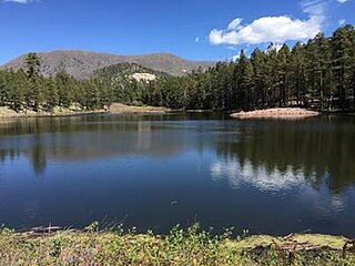
Lake Mary may refer to one of two reservoirs in northern Arizona southeast of Flagstaff. The name may also be used to refer to the two lakes as a whole. The pair of lakes impound the intermittent Walnut Creek upstream from Walnut Canyon. Recreational facilities at both lakes are maintained under the authority of the Coconino National Forest.
Chevelon Canyon Lake is a small reservoir located in northern Arizona, about 28 mi (45 km) northwest of the town of Heber. It is one in a series of small, canyon-bound lakes located on the Mogollon Rim, collectively referred to as the Rim Lakes. It is said to be among the most difficult to access in the region. It is also the second reservoir on Chevelon Creek, downstream from Woods Canyon Lake. The facilities are maintained by Apache–Sitgreaves National Forests division of the USDA Forest Service.

Woods Canyon Lake is a small lake located in northern Arizona, United States, about 30 mi (48 km) east of the city of Payson. It is one in a series of small, canyon-bound lakes located on the Mogollon Rim, collectively referred to as the Rim Lakes. It is among the more developed and accessible of the Rim Lakes. It is also the first reservoir on Chevelon Creek, upstream from Chevelon Canyon Lake.
Bear Canyon Lake is a lake built by Arizona Game and Fish Department for angler recreation. The facilities are maintained by Apache-Sitgreaves National Forest division of the USDA Forest Service.
Ackre Lake is located in the White Mountains southwest of Alpine, Arizona, off State Route 191. This lake is located in and administered by the Apache-Sitgreaves National Forests. The lake is stocked with trout and grayling. Tiger salamanders are also found in Ackre Lake.

Big Lake is a White Mountains' fishing lake, with attractive size, productivity and visitor amenities. As with most trout waters in Arizona, catch rates are best in spring, during late April and May after the winter ice thaws, and get better later in the summer and into fall until the lake freezes over again in late November. Big Lake is in Apache County and is managed by the Apache-Sitgreaves National Forests.
Bunch Reservoir is one of a trio of lakes on the Little Colorado River that provides trout fishing opportunities in and around the town of Greer.
Carnero Lake is a high elevation shallow lake in Apache County, Arizona. Built in 1979, the lake quickly became popular with anglers, to the dismay of downstream water users. Because of the dispute, the Arizona Game and Fish discontinued stocking for many years. In 1999, the Arizona Game and Fish has acquired a major share of the water rights, setting the stage for a new and vigorous trout fishery.
Crescent Lake is located approximately 2 miles (3.2 km) north of Big Lake. The lake sits at just over 9,000 feet (2,700 m) elevation on the Apache-Sitgreaves National Forests, as such the facilities located here are managed by that authority. Access is restricted in the winter when roads are closed due to snow, generally December to early April.
Nelson Reservoir is a reservoir located in Apache County, Arizona between Springerville and Alpine. The Reservoir is a long and narrow lake which follows the Nutrioso Creek Valley for nearly a mile. Fish that remain in Nelson Reservoir after summer stockings can grow to good size, making it a popular fishing site with local anglers.
Built in 1896 on the Little Colorado River, River Reservoir is the largest and deepest of a trio of lakes collectively known as the Greer Lakes. Drained since 2004 because of safety issues, the dam at River Reservoir was repaired in 2005. Like the other two Greer Lakes, it has new amenities. River Reservoir is located at 8,220 feet (2,510 m) on the Apache-Sitgreaves National Forests.
Built in 1928, Scott Reservoir is an irrigation impoundment on Porter Creek near Pinetop-Lakeside, Arizona, USA. The least developed of the "in town" lakes, trees surround Scott Reservoir. It lies just outside the town limits on the Apache-Sitgreaves National Forests.
Located in the heart of Pinetop-Lakeside, Woodland Lake and the park surrounding it have been called the town's "Crown Jewel." In addition to trout fishing, the lake provides a host of other outdoor recreation opportunities. Woodland Lake lies on Apache-Sitgreaves National Forests property, just west of White Mountain Blvd. in Pinetop.

Parker Canyon Lake is located in southeastern Arizona, 28 miles (45 km) southwest of Sierra Vista around the Huachuca Mountains and about 5 miles (8.0 km) north of the border with Mexico. The lake is a reservoir formed by a dam in Parker Canyon in the south end of the Canelo Hills in southwestern Cochise County. Parker Canyon is a tributary to the Santa Cruz River in the San Rafael Valley. The facilities are maintained by Coronado National Forest division of the USDA Forest Service.

Patagonia Lake is a man-made reservoir in Santa Cruz County, Arizona, United States, located southwest of the town of Patagonia, Arizona and northeast of Nogales. The lake was created by damming Sonoita Creek, and is a popular area for boating and sport fishing. Facilities are maintained by Arizona State Parks as part of Patagonia Lake State Park.
Peña Blanca Lake is a reservoir in Arizona, United States, located 18 miles (29 km) northwest of Nogales. The facilities are maintained by the Coronado National Forest division of the USDA Forest Service. The lake was created in 1957 by the Arizona Game and Fish Department.Back then this lake was known for a plush resort that was located there. In 2008, the lake was closed to clean mercury contamination within the sediment, thought to be from old mines in the area. Also the former plush resort was removed as well. The lake was reopened in August 2009. In 2013, an Arizona Department of Environmental Quality report showed that mercury levels were similar to those before the lake was drained and dredged. One potential cause for the high mercury could be naturally occurring mercury seeping through the faults or a spring in the lake, though these claims are still under investigation.
Hulsey Lake is a lake near Escudilla Peak in the Apache National Forest, Arizona. It is located at 8,620 feet (2,630 m) on the Apache-Sitgreaves National Forests. It is an impoundment of Hulsey Creek, a tributary of Nutrioso Creek. Due to snow and ice, the lake is usually inaccessible from November to mid-April.

Willow Springs Lake is a cold water lake located on top of the Mogollon Rim in northern Arizona, about 23 mi (37 km) east of the city of Payson in the Apache-Sitgreaves National Forests, immediately adjacent to SR 260. It is a canyon-bound lake located on the Mogollon Rim, and is part of the collectivity known as the Rim Lakes. It can be found upstream from Chevelon Canyon Lake. The facilities are maintained by Apache-Sitgreaves National Forests division of the USDA Forest Service.


