
A Munro is defined as a mountain in Scotland with a height over 3,000 feet (914.4 m), and which is on the Scottish Mountaineering Club (SMC) official list of Munros; there is no explicit topographical prominence requirement. The best known Munro is Ben Nevis, the highest mountain in the British Isles at 4,411 ft.

The Merrick, or simply Merrick, is a mountain in the Range of the Awful Hand, a sub-range of the Galloway Hills range, part of the Southern Uplands of Scotland. The summit elevation is 843 metres, making it the highest mountain in the Southern Uplands and southern Scotland.

The mountains and hills of the British Isles are categorised into various lists based on different combinations of elevation, prominence, and other criteria such as isolation. These lists are used for peak bagging, whereby hillwalkers attempt to reach all the summits on a given list, the oldest being the 282 Munros in Scotland, created in 1891.

The Range of the Awful Hand is a range of hills in the Galloway Hills range, part of the Southern Uplands of Scotland. The most westerly of three parallel ridges, the range is neighboured to the east by the Dungeon Hills and the Rhinns of Kells. The Minnigaff Hills also lie southeast. In total, these four ranges are part of the Galloway Forest Park. The ridge is split between South Ayrshire and Dumfries and Galloway.

Caer Mote is a hill of 289 metres (948 ft) in the north of the English Lake District near Bothel, Cumbria. Its summit lies just outside the boundary of the Lake District National Park and offers a view of Bassenthwaite Lake. Under the name Caermote Hill it is the subject of a chapter of Wainwright's book The Outlying Fells of Lakeland. Wainwright's route is an ascent from Bothel to the northern summit St. John's Hill at 285 metres (935 ft), continuing south to the main summit and south east to meet a minor road beside the Roman fort and follow that road north for an anticlockwise circuit. In his original book Wainwright lists the height as 920 feet, but in the 2011 2nd edition Chris Jesty corrects this to 948 feet.

Erie Hill is a hill in the Moffat Hills range, part of the Southern Uplands of Scotland. A relatively compact summit in comparison to the other hills in the range, it is commonly climbed as part of a round starting from Talla Linnfoots to the north.

Molls Cleuch Dod is a hill in the Moffat Hills range, part of the Southern Uplands of Scotland. A broad, grassy outlier of the surrounding hills, it is commonly ascended in rounds beginning from the Megget Stane and Talla Linnfoots or as a detour from the Grey Mare's Tail.

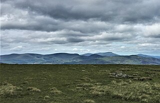
Under Saddle Yoke is a hill in the Moffat Hills range, part of the Southern Uplands of Scotland. Despite its name, it is 10m higher than its neighbouring top, Saddle Yoke. Located in a dramatic position on a small, grassy ridge in between two deep glens, Blackhope and Carrifran, it awards excellent views into the rest of the Moffat Hills and the Ettrick Hills opposite. Although incomparable to the Scottish Highlands and not particularly precipitous, the ridge between and atop the Yokes is the narrowest summit ridge in the Southern Uplands. The electric fence that comes out of Blackshope and crosses the ridge to the north of Saddle Yoke and then continues down into Carrifran hasn't worked in 40 years. A popular round known as the Hart Fell Horseshoe begins near Blackshope and normally ascends Nether Coomb Craig first, then passing over Swatte Fell, Hart Fell and looping round Hartfell Rig to the Saddle Yokes before the descent.

Ettrick Pen is a hill in the Ettrick Hills range, part of the Southern Uplands of Scotland. A remote peak, It lies southwest of the village of Ettrick, on the border of the Scottish Borders and Dumfries and Galloway. The highest of the Ettrick Hills, it is crossed by the Southern Upland Way and is a prominent landmark from many directions. Its summit is topped by an ancient cairn.

Windlestraw Law is a hill in the Moorfoot Hills range, part of the Southern Uplands of Scotland. It is the highest peak of the range, and lies north of the town of Innerleithen in the Scottish Borders. A large and boggy peak, it is usually climbed from either its western slopes or the longer route from Tweeddale to the south.

Blacklorg Hill is a hill in the Carsphairn and Scaur Hills range, part of the Southern Uplands of Scotland. It lies southeast of the town of New Cumnock in Ayrshire, directly east of the Afton Reservoir. It is most frequently climbed along with the neighbouring hills, starting from the Glen Afton road.

Alhang is a hill in the Carsphairn and Scaur Hills range, part of the Southern Uplands of Scotland. It is the lowest Donald hill in the range; Meikledodd Hill is 1m higher. The northern slopes of the hill are the source of the River Afton. It is most easily climbed from the Water of Ken to the east or as a round from Glen Afton to the north.
The Dungeon Hills are a range of hills in the Galloway Hills range, part of the Southern Uplands of Scotland. The central of three parallel ridges, they are neighboured by the Range of the Awful Hand to the west and the Rhinns of Kells to the east. The range is also perpendicular to the Minnigaff Hills range, immediately south. In total, these four ranges are part of the Galloway Forest Park.

The Rhinns of Kells are a range of hills in the Galloway Hills range, part of the Southern Uplands of Scotland. The most easterly of three parallel ridges, they are neighboured to the west by the Range of the Awful Hand and the Dungeon Hills. The eastern portion of the Minnigaff Hills range lies immediately southwest of the range. In total, these four ranges are part of the Galloway Forest Park. The ridge is located entirely within Dumfries and Galloway, with the base of the western flanks being a northwestern boundary of the county.
The Minnigaff Hills are a range of hills in the Galloway Hills range, part of the Southern Uplands of Scotland. A southerly range, they are perpendicular to the Range of the Awful Hand, Dungeon Hills and Rhinns of Kells to the north. In total, these four ranges are part of the Galloway Forest Park.

The Culter Hills, Coulter Fells or variations thereof, are a range of hills, part of the Southern Uplands of Scotland. They are neighboured to the east by the Manor Hills and are split roughly in half by the border between South Lanarkshire and the Scottish Borders.

The Ettrick Hills are a range of hills that are part of the Southern Uplands of Scotland. They are neighboured to the northwest by the Moffat Hills and are located mainly within the Scottish Borders; however, the Dumfries and Galloway border covers the south and southwesterly flanks.

