Geography | |
---|---|
Location | Blackwall, River Thames |
Coordinates | 51°30′23″N0°0′07.1″W / 51.50639°N 0.001972°W |
OS grid reference | TQ385802 |
Area | 4,181 m2 (45,000 sq ft) |
The Blackwall Rock was a reef [1] in the River Thames in East London. The rock provided a useful shelter for moored vessels, [2] but also proved a hazardous obstruction to river navigation. [3] It was removed in the early 19th century following the opening of the adjacent West India Docks.
Blackwall Rock was located a short distance upriver of Blackwall Stairs, the southern end of a causeway from Poplar High Street which crossed extensive marshland, between the entrances of the West and East India Docks. [4] The rock was always a hazard to river traffic, [1] as it sometimes lay less than 3 feet (1 m) below the surface at low tide. [5] The entrance to the West India Docks, just to the south-west of the rock, was substantially obstructed by the reef upon the docks' opening in 1802. [6] In 1803, in his Strictures on the Alarming Progress of the Blackwall Rock in the River Thames, Robert Edington wrote that he surveyed the rock under the direction of the Corporation of the City of London's harbourmaster, Captain John Raymond Snow. [7] Prior to his survey, Edington was under the impression that the rock was 40 by 30 feet (12.2 m × 9.1 m); [8] Abraham Rees's Cyclopædia , published shortly before Edington's survey, had given these measurements. [9] Rees asserted that newspaper reports of one of Thomas Boddington's West Indiaman vessels being wrecked on the rock were incorrect, and that the relatively recent installation of piling and booms prevented ships from coming near the reef. [9]
Edington's subsequent measurements gave the rough dimensions as 600 by 150 feet (183 m × 46 m). [8] He surmised that the cost of the rock's removal—even with the use of prison labour—would be £50,000, [10] and was surprised by some contract tenders who proposed fees of little more than £1,000. [10] He gathered specimens of the rock, and said that it was not a "natural stone". He stated that he had been told the rock was first discovered in the early 18th century when an Indiaman was wrecked upon it—possibly retelling the story refuted by Rees in 1802. [11] Edington described the rock's composition as "a strong cemented iron stone, formed by an elective attraction of the lapidious or earthly basis, to the very numerous metallic particles always suspended in the river". [11]
Most sources give the rock's dimensions as 300-by-150-foot (91 m × 46 m), [2] [5] and an 1846 report by the Tidal Harbours Commission described it as an outcrop of plum-pudding stone. [12]
The opening of the West and East India Docks in 1802 and 1803 respectively necessitated the removal of the rock, which obstructed safe navigation to their entrances. [13] Edington proposed the use of prison labour; he recommended that "a hulk with 200 convicts be moored near adjoining the rock, where these convicts should be employed, with proper instruments in drilling and blasting it up". [14] He then recommended the use of ordnance; his proposal employed an iron caisson to create a dry working area, with explosives being driven into a 24-inch (61 cm) hole. The system would ensure that the explosion would drive the force through the rock, breaking it, rather than forcing the explosive charge back through the drilled hole. He conceded that the resulting explosion might blow the caisson "to atoms, and probably be the death of some of the poor men". [14]
Early attempts to break the rock with explosives were largely unsuccessful. William Jessop was engaged by Trinity House to undertake the rock's removal; [15] he subcontracted Ralph Walker as a consultant [16] and James Spedding as engineer. [17] Labourers from Trinity House undertook the physical work. It is also possible that Richard Trevithick worked on the project at some time. [13]
Jessop's proposal used a chisel, operated from a barge much as with pile driving. This method successfully reduced the height of the rock by 15 feet (4.6 m), after which a cylindrical coffer dam (also described as being like a diving bell) was employed to allow workers' access to remove rubble. [5] The works lasted from 1804 to 1808, and cost £42,000. [5] Of this, Spedding's contract was £26,000. [17]
The removal of the rock caused nearby sandy shoals to disappear. [12] John William Norie's Sailing Directions for the River Thames, published in 1847, makes no mention of a navigational hazard in the area of the former rock. [18]
The West India Docks are a series of three docks, quaysides and warehouses built to import goods from and export goods and occasionally passengers to the British West Indies on the Isle of Dogs in London the first of which opened in 1802. Following their commercial closure in 1980, the Canary Wharf development was built around the wet docks by narrowing some of their broadest tracts.
Blackwall is an area of Poplar, in the London Borough of Tower Hamlets, East London. The neighbourhood includes Leamouth and the Coldharbour conservation area.
Arram Beck is a small stream in the East Riding of Yorkshire, England, running through high embankments and flowing eastwards from the village of Arram to join the River Hull. Depths are variable due to the tidal nature of the Hull. It provides habitat for a variety of fish species and chub have also been stocked here too.
A Biographical Dictionary of Civil Engineers in Great Britain and Ireland discusses the lives of the people who were concerned with building harbours and lighthouses, undertook fen drainage and improved river navigations, built canals, roads, bridges and early railways, and provided water supply facilities. Volume One, published in 2002, covers the years from 1500 to 1830, while Volume Two, published in 2008, covers 1830 to 1890. The principal editor of the first volume was Professor A. W. Skempton, and the entries were written by a number of specialist historians.
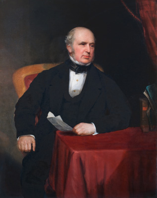
James Walker was an influential British civil engineer.
Chirk Aqueduct is a 70-foot (21 m) high and 710-foot (220 m) long navigable aqueduct that carries what is now the Llangollen Canal across the Ceiriog Valley near Chirk, on the England-Wales border, spanning the two countries.
Josias Jessop (1781–1826) was a noted canal engineer, and second son of William Jessop, one of the great canal engineers of the late eighteenth and early nineteenth centuries. He was trained by his father, and worked under him on his early projects, but proved his abilities during the construction of Bristol harbour. He became an independent consulting engineer from 1811. He died fourteen years later, a little before he reached the age of 45.
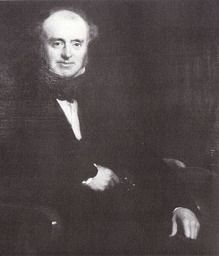
James Meadows Rendel FRS was a British civil engineer.
The City Canal was a short, and short-lived, canal excavated across the Isle of Dogs in east London, linking two reaches of the River Thames. Today, it has been almost completely reconstructed to form the South Dock of the West India Docks.
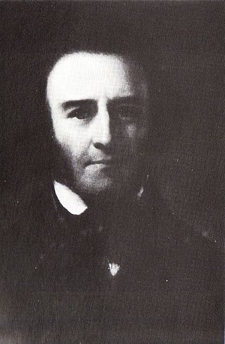
Joshua Field FRS was a British civil engineer and mechanical engineer.
Thomas Morris (c.1754–1832) was an English architect and engineer. In 1784 he supervised the building of a dock at Glasson, on the River Lune.
Henry Robinson Palmer (1795–1844) was a British civil engineer who designed the world's second monorail and the first elevated railway. He is also credited as the inventor of corrugated metal roofing, still one of the world's major building materials.
James Jardine was a Scottish civil engineer, mathematician and geologist. He was the first person to determine mean sea level. He built tunnels and bridges, including for the Innocent Railway, and built reservoirs including Glencorse, Threipmuir, Harlaw for Edinburgh Water Company, and Cobbinshaw for the Union Canal.
William Chapman (1749–1832) was an English engineer. Born in Whitby, he worked on the construction of the Old and Humber Docks in Hull, as well as many drainage and canal projects. He is credited with the invention of the bogie and articulation for rail vehicles.
John Gibb (1776–1850) was a Scottish civil engineer and contractor whose work included the construction of harbours, bridges, roads, lighthouses, and railways in the United Kingdom, primarily in Scotland. He was a close associate of Thomas Telford, who employed him on many of his civil engineering projects during the first half of the 19th century.
Ralph Walker was a Scottish civil engineer, particularly associated with harbour engineering works in London.
James Anderson was a Scottish civil engineer.
John Timperley (1796-1856), was a British Civil engineer, active in dock work in the north and east of England and elsewhere - also the first recipient of the Telford Medal.
George Burn was an architect, civil engineer and contractor active in Scotland in the late 18th and early 19th centuries.
James Barnes was a canal and railway engineer in England and twice Mayor of Banbury.