
U.S. Route 30 or U.S. Highway 30 (US 30) is an east–west main route of the United States Numbered Highway System, with the highway traveling across the Northern U.S. With a length of 3,112 miles (5,008 km), it is the third-longest U.S. Highway, after US 20 and US 6. The western end of the highway is at US 101 in Astoria, Oregon; the eastern end is at Virginia Avenue, Absecon Boulevard, and Adriatic Avenue in Atlantic City, New Jersey. The "0" as the last digit in the number indicates that it is a coast-to-coast route and a major east–west route. Despite long stretches of parallel and concurrent Interstate Highways, it has not been decommissioned unlike other long-haul routes such as US 66. It is also the only U.S. Highway that has always been coast-to-coast since the beginning of U.S. Numbered Highway System.

U.S. Route 34 (US 34) is an east–west United States highway that runs for 1,122 miles (1,806 km) from north-central Colorado to the western suburbs of Chicago. Through Rocky Mountain National Park it is known as the Trail Ridge Road where it reaches an elevation of 12,183 feet (3,713 m), making it one of the highest paved through highways in the United States. The highway's western terminus is Granby, Colorado at US 40. Its eastern terminus is in Berwyn, Illinois at Illinois Route 43 and Historic US 66.

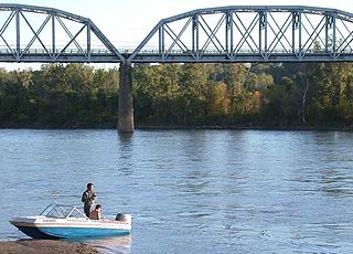
The Fort Madison Toll Bridge is a tolled, double-decked swinging truss bridge over the Mississippi River that connects Fort Madison, Iowa, and unincorporated Niota, Illinois. A double-track railway occupies the lower deck of the bridge, while two lanes of road traffic are carried on the upper deck. The bridge is about 1 mile (1.6 km) long with a swing span of 525 feet (160 m), and was the longest and largest double-deck swing-span bridge in the world when constructed in 1927. It replaced an inadequate combination roadway/single-track bridge completed in 1887. The main river crossing consists of four 270-foot (82 m) Baltimore through truss spans and a swing span made of two equal arms, 266 feet (81 m) long. In 1999, it was listed in the National Register of Historic Places under the title, Fort Madison Bridge, ID number 99001035. It was also documented as survey number IA-62 by the Historic American Engineering Record, archived at the Library of Congress. Construction and photographic details were recorded at the time in Scientific American magazine.

The Rulo Rail Bridge is a truss bridge across the Missouri River connecting Rulo, Nebraska, with Holt County, Missouri, and is used by the BNSF Railway to transport coal from Wyoming and Colorado to Midwest power plants.

The Ak-Sar-Ben Bridge was a Whipple through truss bridge that was the first road bridge to cross the Missouri River connecting Omaha, Nebraska and Council Bluffs, Iowa. It was replaced in 1966 by the Interstate 480 girder bridge.
The Union Pacific Missouri River Bridge is a rail truss bridge across the Missouri River between Council Bluffs, Iowa, and Omaha, Nebraska.
The Plattsmouth Bridge is a truss bridge over the Missouri River connecting Cass County, Nebraska, and Mills County, Iowa at Plattsmouth, Nebraska. Until 2014, it carried U.S. Highway 34 across the river.
The Mormon Bridge is a bridge composed of two cantilevers that crosses the Missouri River connecting Pottawattamie County, Iowa with the Florence neighborhood of Omaha, Nebraska via Interstate 680 (Iowa-Nebraska). The bridge is officially called the Mormon Pioneer Memorial Bridge due to its location on the historic Mormon Trail, which passed nearby.

Nebraska Highway 2 (N-2) is a state highway in Nebraska consisting of two discontinuous segments. The western segment begins at the South Dakota border northwest of Crawford and ends southeast of Grand Island at an intersection with Interstate 80 (I-80). The eastern segment begins in Lincoln and ends at the Iowa border at Nebraska City. Previously, the two segments were connected via a route shared with U.S. Highway 34 (US 34) between Grand Island and Lincoln.

Interstate 80 (I-80) in the US state of Nebraska runs east from the Wyoming state border across the state to Omaha. Construction of the stretch of I-80 spanning the state was completed on October 19, 1974. Nebraska was the first state in the nation to complete its mainline Interstate Highway System.

The Lincoln Highway in Omaha, Nebraska, runs east–west from near North 183rd Street and West Dodge Road in Omaha, Nebraska, towards North 192nd Street outside of Elkhorn. This section of the Lincoln Highway, one of only 20 miles (32 km) that were paved with brick in Nebraska, is one of the most well-preserved in the country. The roadway was listed on the National Register of Historic Places in 1984. The Lincoln Highway was the first road across the United States, traversing coast-to-coast from Times Square in New York City to Lincoln Park in San Francisco, California.

Transportation in Omaha, Nebraska, includes most major modes, such as pedestrian, bicycle, automobile, bus, train and airplane. While early transportation consisted of ferries, stagecoaches, steamboats, street railroads, and railroads, the city's transportation systems have evolved to include the Interstate Highway System, parklike boulevards and a variety of bicycle and pedestrian trails. The historic head of several important emigrant trails and the First transcontinental railroad, its center as a national transportation hub earned Omaha the nickname "Gate City of the West" as early as the 1860s.
U.S. Highway 30 (US 30) is part of the United States Numbered Highway System that runs for 3,112 miles (5,008 km) from Astoria, Oregon, to Atlantic City, New Jersey. Within the state of Nebraska, it is a state highway that travels 451.74 miles (727.01 km) west to east across the state from the Wyoming state line west of Bushnell to the Missouri River in Blair on the Iowa state line. Despite not intersecting Interstate 80 (I-80) even once, much of its length until Grand Island is closely parallel with the Interstate, not being more than one or two miles away. For most of its route, US 30 travels within the Platte River valley, adjacent to or near the river between Brule and Fremont, a distance of just over 300 miles (480 km). This corridor was also highly traveled during westward expansion along the California and Oregon trails, it was also used by the Pony Express and first transcontinental railroad. The landscape is dominated by vast agricultural fields within the fertile Platte River valley across the center of the state, while the western portion passes through higher plains and the eastern portion through the rolling hills adjacent to the Missouri River valley.
Dodge Street is the main east–west street in Omaha, Nebraska. Numbered as U.S. Route 6 (US 6) for most of its length, the street starts in Downtown Omaha and connects to West Dodge Road just west of 78th Street. From there, it continues westward through the remainder of Douglas County.

The Blair Bridge carries the Union Pacific Railroad's Blair Subdivision between the U.S. states of Nebraska and Iowa, across the Missouri River near Blair, Nebraska. It was built in 1883 by the Sioux City and Pacific Rail Road, replacing a car ferry. Automobile traffic crosses via the parallel Blair Bridge.

U.S. Route 75 was a part of the United States Numbered Highway System that runs for 1,239 miles (1,994 km) from Dallas, Texas to Kittson County, Minnesota where it ends just short of the Canada–United States border. Within the State of Nebraska it is a state highway that enters Nebraska on the Kansas state line about 9 miles (14 km) south of Dawson and travels north across the extreme eastern portion of the state, to the Nebraska–Iowa border in South Sioux City where it crosses the Missouri River along a concurrency with Interstate 129. The northern 210 miles (340 km) of the route generally travels parallel to the Missouri River. The 87.32-mile (140.53 km) section between the I-680 interchange in Omaha and the Interstate 129 interchange is designated the Lewis & Clark Scenic Byway, one of nine scenic byways in the state.

The Siouxland Veterans Memorial Bridge is a through arch bridge which carries U.S. Route 77 across the Missouri River between Sioux City, Iowa, and South Sioux City, Nebraska.
The Gibson Bend of the Missouri River is a meander located in Pottawattamie County, Iowa and Douglas County, Nebraska, located at 41°11′15″N95°55′15″W. The Gibson neighborhood is a community area in Omaha, Nebraska abutting the Gibson Bend.

The Mark Twain Memorial Bridge was a cantilevered through truss bridge carrying US 36 over the Mississippi River. It was replaced in 2000 with the extension of I-72 and subsequently demolished.

