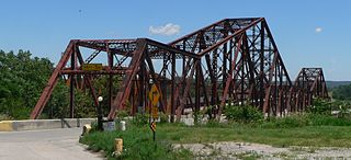
Survey No. Name (as assigned by HAER) Status Type [2] Built Documented Carries Crosses Location County Coordinates IA-1 Pacific Shortline Bridge Replaced Rim-bearing swing span 1896 1980 US 77 Missouri River Sioux City, Iowa , and South Sioux City, Nebraska Woodbury County, Iowa , and Dakota County, Nebraska 42°29′15″N 96°24′49″W / 42.48750°N 96.41361°W / 42.48750; -96.41361 (Pacific Shortline Bridge ) IA-2 Eagle Point Bridge Replaced Pennsylvania truss 1902 1982 US 61 / US 151 Mississippi River Dubuque, Iowa , and Hazel Green, Wisconsin Dubuque County, Iowa , and Grant County, Wisconsin 42°32′13″N 90°38′38″W / 42.53694°N 90.64389°W / 42.53694; -90.64389 (Eagle Point Bridge ) IA-3 Keokuk and Hamilton Bridge Extant Swing span 1916 1982 Keokuk Junction Railway Mississippi River Keokuk, Iowa , and Hamilton, Illinois Lee County, Iowa , and Hancock County, Illinois 40°23′28″N 91°22′24″W / 40.39111°N 91.37333°W / 40.39111; -91.37333 (Keokuk and Hamilton Bridge ) IA-4 Marsh Rainbow Arch Bridge Replaced Reinforced concrete through arch 1927 1980 West 8th Street North Chicago, Rock Island and Pacific Railroad Newton Jasper 41°42′06″N 93°03′46″W / 41.70167°N 93.06278°W / 41.70167; -93.06278 (Marsh Rainbow Arch Bridge ) IA-5 Boyleston Bridge Replaced Parker truss 1897 1985 CR W75 Skunk River Lowell Henry 40°50′24″N 91°30′07″W / 40.84000°N 91.50194°W / 40.84000; -91.50194 (Boyleston Bridge ) IA-6 Sutliff's Ferry Bridge Abandoned Parker truss 1898 1982 Sutliff Road Cedar River Solon Johnson 41°50′23″N 91°23′33″W / 41.83972°N 91.39250°W / 41.83972; -91.39250 (Sutliff's Ferry Bridge ) IA-7 Mill Rock Bridge Replaced Pratt truss 1913 1983 CR Y34 Bear Creek Monmouth Jackson 42°03′44″N 90°50′25″W / 42.06222°N 90.84028°W / 42.06222; -90.84028 (Mill Rock Bridge ) IA-8 South Third Avenue Bridge Replaced Reinforced concrete through arch 1920 1979 Iowa 14 (South Third Avenue) Linn Creek Marshalltown Marshall 42°02′27″N 92°54′29″W / 42.04083°N 92.90806°W / 42.04083; -92.90806 (South Third Avenue Bridge ) IA-9 Traer Street Bridge Replaced Pennsylvania truss 1903 1980 Traer Street Shell Rock River Greene Butler 42°53′43″N 92°48′10″W / 42.89528°N 92.80278°W / 42.89528; -92.80278 (Traer Street Bridge ) IA-10 Eureka Bridge Relocated Bowstring arch truss 1872 1983 City Park path Man-made depression Castalia Winneshiek 43°06′27″N 91°40′23″W / 43.10750°N 91.67306°W / 43.10750; -91.67306 (Eureka Bridge ) IA-11 Taylor Bridge Replaced Reinforced concrete through arch 1924 1983 US 18 Bus. Winnebago River Mason City Cerro Gordo 43°08′53″N 93°09′44″W / 43.14806°N 93.16222°W / 43.14806; -93.16222 (Taylor Bridge ) IA-15 Melan Arch Bridge [lower-alpha 1] Relocated Reinforced concrete closed-spandrel arch 1893 1995 Emma Sater Park path Man-made depression Rock Rapids Lyon 43°25′57″N 96°09′15″W / 43.43250°N 96.15417°W / 43.43250; -96.15417 (Melan Arch Bridge ) IA-17 Open Spandrel Bridge Replaced Reinforced concrete open-spandrel arch 1919 1985 Hawkeye Avenue Des Moines River Fort Dodge Webster 42°30′46″N 94°12′13″W / 42.51278°N 94.20361°W / 42.51278; -94.20361 (Open Spandrel Bridge ) IA-18 Lower Plymouth Rock Bridge Replaced Bowstring arch truss 1877 1985 Cold Water Creek Road Upper Iowa River Kendallville Winneshiek 43°25′54″N 91°59′50″W / 43.43167°N 91.99722°W / 43.43167; -91.99722 (Lower Plymouth Rock Bridge ) IA-19 Freeport Bridge [lower-alpha 2] Relocated Bowstring arch truss 1878 1985 Clay Hill Road Upper Iowa River Decorah Winneshiek 43°18′19″N 91°44′33″W / 43.30528°N 91.74250°W / 43.30528; -91.74250 (Freeport Bridge ) IA-20 Burlington Bridge [lower-alpha 3] Replaced Swing span 1893 1985 BNSF Railway Mississippi River Burlington, Iowa , and Gulfport, Illinois Des Moines County, Iowa , and Henderson County, Illinois 40°47′55″N 91°05′31″W / 40.79861°N 91.09194°W / 40.79861; -91.09194 (Burlington Bridge ) IA-21 MacArthur Bridge Replaced Cantilever 1917 1987 US 34 Mississippi River Burlington, Iowa , and Gulfport, Illinois Des Moines County, Iowa , and Henderson County, Illinois 40°48′43″N 91°05′44″W / 40.81194°N 91.09556°W / 40.81194; -91.09556 (MacArthur Bridge ) IA-29 Rock Valley Bridge Replaced Reinforced concrete through arch 1918 1988 US 30 North Timber Creek Marshall Marshall 42°00′31″N 92°51′07″W / 42.00861°N 92.85194°W / 42.00861; -92.85194 (Rock Valley Bridge ) IA-30 Benton Street Bridge Replaced Steel built-up girder 1949 1989 Benton Street Iowa River Iowa City Johnson 41°39′02″N 91°32′20″W / 41.65056°N 91.53889°W / 41.65056; -91.53889 (Benton Street Bridge ) IA-31 Cottonville Bridge Replaced Bowstring arch truss 1946 1990 CR D61 Farmers Creek tributary Maquoketa Jackson 42°14′18″N 90°37′33″W / 42.23833°N 90.62583°W / 42.23833; -90.62583 (Cottonville Bridge ) IA-32 Supple Ford Bridge Replaced Bowstring arch truss 1875 1990 Temple Hill Road Maquoketa River south fork Clay Mills Jones 42°11′08″N 90°58′39″W / 42.18556°N 90.97750°W / 42.18556; -90.97750 (Supple Ford Bridge ) IA-35 Davis Bridge Replaced Bowstring arch truss 1879 1991 CR 16 Upper Iowa River Lime Springs Howard 43°28′00″N 92°17′52″W / 43.46667°N 92.29778°W / 43.46667; -92.29778 (Davis Bridge ) IA-36 Sixth Street Viaduct Replaced Pratt truss 1886 1991 Sixth Street Burlington Northern Railroad Burlington Des Moines 40°48′33″N 91°06′24″W / 40.80917°N 91.10667°W / 40.80917; -91.10667 (Sixth Street Viaduct ) IA-37 Bevington Bridge Replaced Pratt truss 1882 1992 Warren Street Middle River Bevington Madison 41°21′33″N 93°47′25″W / 41.35917°N 93.79028°W / 41.35917; -93.79028 (Bevington Bridge ) IA-38 Waverly Junction Bridge Replaced Parker truss 1911 1991 Country Road Shell Rock River Waverly Bremer 42°39′56″N 92°30′45″W / 42.66556°N 92.51250°W / 42.66556; -92.51250 (Waverly Junction Bridge ) IA-39 Honey Creek Bridge Replaced Reinforced concrete girder 1910 1992 105th Street Honey Creek Bangor Marshall 42°12′05″N 93°05′56″W / 42.20139°N 93.09889°W / 42.20139; -93.09889 (Honey Creek Bridge ) IA-40 Okoboji Bridge Relocated Reinforced concrete girder 1929 1992 US 71 Strait between East and West Okoboji Lake Okoboji Dickinson 43°22′37″N 95°07′40″W / 43.37694°N 95.12778°W / 43.37694; -95.12778 (Okoboji Bridge ) IA-42 86th Street Overpass Replaced Aluminum built-up girder 1958 1992 Northwest 86th Street I-35 / I-80 Urbandale Polk 41°39′08″N 93°44′11″W / 41.65222°N 93.73639°W / 41.65222; -93.73639 (86th Street Overpass ) IA-43 Black Hawk Bridge Extant Cantilever 1931 1995 Iowa 9 /WIS 82 Mississippi River Lansing, Iowa , and De Soto, Wisconsin Allamakee County, Iowa , and Crawford County, Wisconsin 43°21′55″N 91°12′52″W / 43.36528°N 91.21444°W / 43.36528; -91.21444 (Black Hawk Bridge ) IA-44 Chicago & Northwestern Railroad Viaduct Bypassed Viaduct 1901 1995 Chicago and North Western Railway Des Moines River Boone Boone 42°03′35″N 93°58′08″W / 42.05972°N 93.96889°W / 42.05972; -93.96889 (Chicago & Northwestern Railroad Viaduct ) IA-45 Wagon Bridge Demolished Pennsylvania truss 1910 1995 200th Street Des Moines River Boone Boone 42°03′46″N 93°58′10″W / 42.06278°N 93.96944°W / 42.06278; -93.96944 (Wagon Bridge ) IA-46 Lake City Bridge Bypassed Reinforced concrete through arch 1914 1995 Rainbow Bend County Park trail Raccoon River Lake City Calhoun 42°13′46″N 94°45′16″W / 42.22944°N 94.75444°W / 42.22944; -94.75444 (Lake City Bridge ) IA-47 Elkader Bridge Extant Stone arch 1889 1995 Bridge Street Turkey River Elkader Clayton 42°51′18″N 91°24′13″W / 42.85500°N 91.40361°W / 42.85500; -91.40361 (Elkader Bridge ) IA-48 Nishnabotna River Bridge Extant Bowstring arch truss 1945 1995 310th Street Nishnabotna River Manilla Crawford 41°52′02″N 95°16′01″W / 41.86722°N 95.26694°W / 41.86722; -95.26694 (Nishnabotna River Bridge ) IA-49 Euritt Bridge Abandoned Pratt truss 1882 1995 River Road Grand River Leon Decatur 40°43′18″N 93°52′33″W / 40.72167°N 93.87583°W / 40.72167; -93.87583 (Euritt Bridge ) IA-50 Cascade Bridge Abandoned Baltimore truss 1896 1995 South Main Street Cascade Ravine Burlington Des Moines 40°46′53″N 91°05′55″W / 40.78139°N 91.09861°W / 40.78139; -91.09861 (Cascade Bridge ) IA-51 White Water Creek Bridge Relocated Pratt truss 1872 1995 Bergfeld Pond Trail Bergfeld Pond Bernard Dubuque 42°29′21″N 90°46′33″W / 42.48917°N 90.77583°W / 42.48917; -90.77583 (White Water Creek Bridge ) IA-52 Ellsworth Ranch Bridge Extant Pratt truss 1895 1995 130th Street Des Moines River east fork Dolliver Emmet 43°27′36″N 94°34′49″W / 43.46000°N 94.58028°W / 43.46000; -94.58028 (Ellsworth Ranch Bridge ) IA-53 Twin Bridge Extant Reinforced concrete closed-spandrel arch 1910 1995 130th Street Little Volga River Fayette Fayette 42°49′4″N 91°52′41″W / 42.81778°N 91.87806°W / 42.81778; -91.87806 (Twin Bridge ) IA-54 Dietzenbach Bottom Bridge Bypassed Warren truss 1891 1995 Pheasant Road Turkey River Saint Lucas Fayette 43°04′39″N 91°53′21″W / 43.07750°N 91.88917°W / 43.07750; -91.88917 (Dietzenbach Bottom Bridge ) IA-55 West Auburn Bridge Bypassed Whipple truss 1881 1995 Neon Road Turkey River West Union Fayette 43°00′58″N 91°52′43″W / 43.01611°N 91.87861°W / 43.01611; -91.87861 (West Auburn Bridge ) IA-56 Alden Bridge Extant Reinforced concrete rigid frame 1936 1995 Main Street Iowa River Alden Hardin 42°31′16″N 93°22′32″W / 42.52111°N 93.37556°W / 42.52111; -93.37556 (Alden Bridge ) IA-57 Hardin City Bridge Relocated Whipple truss 1879 1995 170th Street Iowa River Steamboat Rock Hardin 42°26′55″N 93°06′34″W / 42.44861°N 93.10944°W / 42.44861; -93.10944 (Hardin City Bridge ) IA-58 Fremont Mill Bridge [lower-alpha 2] Relocated Bowstring arch truss 1873 1995 Central Park trail Central Park Lake Anamosa Jones 42°06′38″N 91°08′26″W / 42.11056°N 91.14056°W / 42.11056; -91.14056 (Fremont Mill Bridge ) IA-59 Hale Bridge Relocated Bowstring arch truss 1879 1995 Wapsipinicon State Park trail Wapsipinicon River Oxford Junction Jones 42°05′34″N 91°16′29″W / 42.09278°N 91.27472°W / 42.09278; -91.27472 (Hale Bridge ) IA-60 Corbett's Mill Bridge Bypassed Bowstring arch truss 1871 1995 Abandoned road Maquoketa River Scotch Grove Jones 42°12′00″N 91°03′34″W / 42.20000°N 91.05944°W / 42.20000; -91.05944 (Corbett's Mill Bridge ) IA-61 Bridgeport Bridge Bypassed Pennsylvania truss 1904 1995 Abandoned road Skunk River Denmark Lee and Des Moines 40°47′25″N 91°21′50″W / 40.79028°N 91.36389°W / 40.79028; -91.36389 (Bridgeport Bridge ) IA-62 Fort Madison Bridge Extant Swing span 1927 1995 Iowa 2 /IL 9 Mississippi River Fort Madison, Iowa , and Niota, Illinois Lee County, Iowa , and Hancock County, Illinois 40°37′37″N 91°17′45″W / 40.62694°N 91.29583°W / 40.62694; -91.29583 (Fort Madison Bridge ) IA-64 Holliwell Bridge Bypassed Lattice truss 1880 1995 Holliwell Bridge Road Middle River Winterset Madison 41°19′22″N 93°57′34″W / 41.32278°N 93.95944°W / 41.32278; -93.95944 (Holliwell Bridge ) IA-65 Eveland Bridge Abandoned Whipple truss 1887 1995 285th Street Des Moines River Oskaloosa Mahaska 41°14′34″N 92°45′23″W / 41.24278°N 92.75639°W / 41.24278; -92.75639 (Eveland Bridge ) IA-66 Middle Creek Bridge Abandoned Pratt truss 1898 1995 Ventura Road Middle Creek Rose Hill Mahaska 41°20′24″N 92°27′50″W / 41.34000°N 92.46389°W / 41.34000; -92.46389 (Middle Creek Bridge ) IA-67 NE-5 Plattsmouth Bridge [lower-alpha 3] Bypassed Cantilever 1929 1995 US 34 Missouri River Pacific Junction, Iowa , and Plattsmouth, Nebraska Mills County, Iowa , and Cass County, Nebraska 41°00′04″N 95°52′00″W / 41.00111°N 95.86667°W / 41.00111; -95.86667 (Plattsmouth Bridge ) IA-68 Nodaway River Bridge Relocated Bowstring arch truss 1876 1995 Pilot Grove County Park trail Pilot Grove County Park pond Grant Montgomery 41°08′46″N 95°02′34″W / 41.14611°N 95.04278°W / 41.14611; -95.04278 (Nodaway River Bridge ) IA-69 Pine Mill Bridge Extant Pratt truss 1878 1995 Wildcat Den State Park trail Pine Creek Muscatine Muscatine 41°28′03″N 90°52′02″W / 41.46750°N 90.86722°W / 41.46750; -90.86722 (Pine Mill Bridge ) IA-70 Court Avenue Bridge Extant Reinforced concrete open-spandrel arch 1918 1995 Court Avenue Des Moines River Des Moines Polk 41°35′09″N 93°37′03″W / 41.58583°N 93.61750°W / 41.58583; -93.61750 (Court Avenue Bridge ) IA-71 Southwest Fifth Street Bridge Extant Pratt truss 1898 1995 Southwest 5th Street Raccoon River Des Moines Polk 41°34′37″N 93°37′10″W / 41.57694°N 93.61944°W / 41.57694; -93.61944 (Southwest Fifth Street Bridge ) IA-72 McDowell Bridge Demolished Bowstring arch truss 1883 1995 Abandoned road North Skunk River Montezuma Poweshiek 41°31′14″N 92°40′34″W / 41.52056°N 92.67611°W / 41.52056; -92.67611 (McDowell Bridge ) IA-73 Centennial Bridge Extant Steel arch 1940 1995 US 67 Mississippi River Davenport, Iowa , and Rock Island, Illinois Scott County, Iowa , and Rock Island County, Illinois 41°30′54″N 90°34′54″W / 41.51500°N 90.58167°W / 41.51500; -90.58167 (Centennial Bridge ) IA-74 Keigley Branch Bridge Extant Reinforced concrete closed-spandrel arch 1913 1995 550th Street Keigley Branch Gilbert Story 42°08′13″N 93°36′04″W / 42.13694°N 93.60111°W / 42.13694; -93.60111 (Keigley Branch Bridge ) IA-75 Lincoln Highway Bridge Extant Reinforced concrete cast-in-place slab 1914 1995 US 30 (East 5th Street) Mud Creek Tama Tama 41°57′50″N 92°33′44″W / 41.96389°N 92.56222°W / 41.96389; -92.56222 (Lincoln Highway Bridge ) IA-76 Red Bridge Extant Pratt truss 1920 1996 Abandoned road Yellow River Postville Allamakee 43°07′51″N 91°25′29″W / 43.13083°N 91.42472°W / 43.13083; -91.42472 (Red Bridge ) IA-77 Wapsipinicon River Bridge Extant Reinforced concrete closed-spandrel arch 1927 1996 Iowa 150 Wapsipinicon River Independence Buchanan 42°27′33″N 91°53′27″W / 42.45917°N 91.89083°W / 42.45917; -91.89083 (Wapsipinicon River Bridge ) IA-78 Winnebago River Bridge Extant Reinforced concrete girder 1926 1996 US 65 northbound Winnebago River Mason City Cerro Gordo 43°11′35″N 93°12′36″W / 43.19306°N 93.21000°W / 43.19306; -93.21000 (Winnebago River Bridge ) IA-79 Mederville Bridge Bypassed Reinforced concrete open-spandrel arch 1918 1996 Eclipse Road Volga River Mederville Clayton 42°45′49″N 91°25′18″W / 42.76361°N 91.42167°W / 42.76361; -91.42167 (Mederville Bridge ) IA-80 Cedar River Bridge Extant Steel built-up girder 1936 1996 River Road Cedar River Floyd Floyd 43°12′25″N 92°47′34″W / 43.20694°N 92.79278°W / 43.20694; -92.79278 (Cedar River Bridge ) IA-81 Illinois Central Railroad Overpass Extant Steel built-up girder 1932 1996 Iowa 57 Illinois Central Railroad Ackley Hardin 42°33′24″N 93°02′49″W / 42.55667°N 93.04694°W / 42.55667; -93.04694 (Illinois Central Railroad Overpass ) IA-82 Wapsipinicon River Bridge Bypassed Pratt truss 1887 1996 US 151 Wapsipinicon River Anamosa Jones 42°06′04″N 91°17′31″W / 42.10111°N 91.29194°W / 42.10111; -91.29194 (Wapsipinicon River Bridge ) IA-83 Upper Paris Bridge Extant Whipple truss 1879 1996 Sutton Road Wapsipinicon River Paris Linn 42°14′40″N 91°35′04″W / 42.24444°N 91.58444°W / 42.24444; -91.58444 (Upper Paris Bridge ) IA-84 Southeast Fourteenth Street Bridge Extant Steel built-up girder 1937 1996 US 65 / US 69 (Southeast 14th Street) Des Moines River Des Moines Polk 41°34′32″N 93°35′49″W / 41.57556°N 93.59694°W / 41.57556; -93.59694 (Southeast Fourteenth Street Bridge ) IA-85 Kilbourn Bridge Extant Pratt truss 1909 1996 Lark Avenue Des Moines River Kilbourn Van Buren 40°47′59″N 91°58′14″W / 40.79972°N 91.97056°W / 40.79972; -91.97056 (Kilbourn Bridge ) IA-86 Jefferson Street Viaduct Extant Warren truss 1936 1996 US 34 / US 63 (Jefferson Street) Des Moines River Ottumwa Wapello 41°00′48″N 92°24′44″W / 41.01333°N 92.41222°W / 41.01333; -92.41222 (Jefferson Street Viaduct ) IA-87 Grand Avenue Viaduct Extant Viaduct 1936 1996 US 20 Bus. / Iowa 12 (Gordon Drive) Chicago and North Western Railroad Sioux City Woodbury 42°29′23″N 96°23′31″W / 42.48972°N 96.39194°W / 42.48972; -96.39194 (Grand Avenue Viaduct ) IA-88 Historical Overview of Iowa Bridges 1996 Ames Story IA-89 Structural Study of Reinforced Concrete Arch Bridges Reinforced concrete closed-spandrel arch 1996 Structural analyses of Melan Arch Bridge , etc. Ames Story IA-90 Structural Study of Iron Bowstring Bridges Bowstring arch truss 1996 Structural analyses of Fremont Mill Bridge , etc. Ames Story IA-92 Cutler Bridge Relocated Lattice truss 1871 2002 Winterset City Park trail Middle River tributary Winterset Madison 41°19′52″N 94°00′17″W / 41.33111°N 94.00472°W / 41.33111; -94.00472 (Cutler Bridge ) IA-93 Hogback Bridge Bypassed Lattice truss 1884 2002 Hogback Bridge Road North River Winterset Madison 41°23′11″N 94°02′51″W / 41.38639°N 94.04750°W / 41.38639; -94.04750 (Hogback Bridge ) IA-94 Imes Bridge Relocated Lattice truss 1870 2002 CR G50 trailMan-made depression St. Charles Madison 41°17′21″N 93°48′03″W / 41.28917°N 93.80083°W / 41.28917; -93.80083 (Imes Bridge ) IA-95 Roseman Bridge Extant Lattice truss 1883 2002 CR G47 Middle River Winterset Madison 41°17′34″N 94°08′59″W / 41.29278°N 94.14972°W / 41.29278; -94.14972 (Roseman Bridge ) IA-96 SD-1 Sioux City Bridge [lower-alpha 3] Replaced Whipple truss 1888 1986 Chicago and North Western Railway Missouri River Sioux City, Iowa , and South Sioux City, Nebraska Woodbury County, Iowa , and Dakota County, Nebraska 42°28′28″N 96°23′10″W / 42.47444°N 96.38611°W / 42.47444; -96.38611 (Sioux City Bridge ) IA-97 Ebys Mill Road Bridge Replaced Reinforced concrete girder 1964 2014 CR X73 (Ebys Mill Road) Small Creek Ebys Mill Jones 42°11′56″N 91°02′48″W / 42.19889°N 91.04667°W / 42.19889; -91.04667 (Ebys Mill Road Bridge ) IA-98 Bridge 23780 Replaced Prestressed concrete box beam 1958 2014 US 20 westbound Maquoketa River north fork Dyersville Dubuque 42°28′14″N 91°07′29″W / 42.47056°N 91.12472°W / 42.47056; -91.12472 (Bridge 23780 ) IA-99 Bridge 33470 Replaced Steel built-up girder 1953 2014 US 30 eastbound Cedar River Cedar Rapids Linn 41°55′33″N 91°33′03″W / 41.92583°N 91.55083°W / 41.92583; -91.55083 (Bridge 33470 ) IL-20-P Rock Island Arsenal , Rock Island Bridge Extant Swing span 1896 1985 Mississippi River Davenport, Iowa , and Rock Island, Illinois Scott County, Iowa , and Rock Island County, Illinois 41°31′09″N 90°34′01″W / 41.51917°N 90.56694°W / 41.51917; -90.56694 (Rock Island Arsenal, Rock Island Bridge ) NE-1 Abraham Lincoln Memorial Bridge Replaced Pennsylvania truss 1929 1987 US 30 Missouri River California Junction, Iowa , and Blair, Nebraska Harrison County, Iowa , and Washington County, Nebraska 41°33′04″N 96°05′44″W / 41.55111°N 96.09556°W / 41.55111; -96.09556 (Abraham Lincoln Memorial Bridge ) NE-2 Nebraska City Bridge Demolished Whipple truss 1888 1986 Chicago, Burlington and Quincy Railroad Missouri River Percival, Iowa , and Nebraska City, Nebraska Fremont County, Iowa , and Otoe County, Nebraska 40°40′27″N 95°50′14″W / 40.67417°N 95.83722°W / 40.67417; -95.83722 (Nebraska City Bridge ) NE-6 Omaha Bridge [lower-alpha 3] Replaced Whipple truss 1887 1986 Union Pacific Railroad Missouri River Council Bluffs, Iowa , and Omaha, Nebraska Pottawattamie County, Iowa , and Douglas County, Nebraska 41°14′59″N 95°55′02″W / 41.24972°N 95.91722°W / 41.24972; -95.91722 (Omaha Bridge ) NE-7 Blair Crossing Bridge [lower-alpha 3] Replaced Whipple truss 1883 1986 Union Pacific Railroad Missouri River California Junction, Iowa , and Blair, Nebraska Harrison County, Iowa , and Washington County, Nebraska 41°33′5″N 96°05′44″W / 41.55139°N 96.09556°W / 41.55139; -96.09556 (Blair Crossing Bridge )