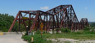
The Plattsmouth Bridge is a truss bridge over the Missouri River connecting Cass County, Nebraska, and Mills County, Iowa at Plattsmouth, Nebraska. Until 2014, it carried U.S. Highway 34 across the river.

The Iowa flood of 2008 was a hydrological event involving most of the rivers in eastern Iowa which began June 8 and continued until July 1. Flooding continued on the Upper Mississippi River in the southeastern area of the state for many more days. The phrase "Iowa's Katrina" was often heard.
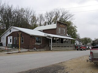
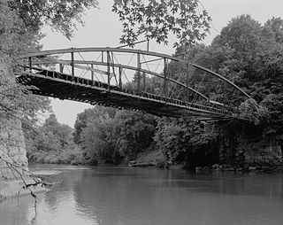
Sutliff is an unincorporated community in Cedar Township, Johnson County, Iowa, United States, just south of Lisbon. The community was founded at the location of Sutliff's ferry. The ferry was operated from 1838 or 1840 onward by Allen C. Sutliff (1796–1873), the elder brother of the Ohio Supreme Court Judge Milton Sutliff (1806–1878). Sutliff, later sold the ferry service to Jim McLellan, whose nickname of "Butts" also tagged the community with the name Buttsville. The community is known for its bridge, listed on the National Register of Historic Places, which was badly damaged during the Iowa Flood of 2008. Baxa's Sutliff Store & Tavern is the main public business. The Sutliff Store has been sitting on the banks of the Cedar River next to the Historic Sutliff Bridge since 1899. The Sutliff Bridge was reconstructed through FEMA funding approved by the Johnson County Board of Supervisors by a 3–2 vote. The reconstruction was supervised by VJ Engineering and construction was completed by Iowa Bridge and Culvert of Washington, Iowa. A ribbon cutting ceremony was held in October 2012 to open the bridge to the public again. It had been closed for four years following the devastation of the 2008 flood.

The Bridgeport Bridge was a historic structure located near Denmark, Iowa, United States. This span was a replacement bridge for the original structure whose middle stone pier was deteriorating. The weaknesses in the old bridge were noted in 1887 and 1893. Both Des Moines and Lee counties financed the $5,110 construction of this bridge, which spanned the Skunk River between the two counties. The 240-foot-long (73 m) Pennsylvania truss bridge was built in 1904 by the Clinton Bridge and Iron Works of Clinton, Iowa. It carried local traffic for nearly 90 years before it was closed. On February 27, 2024 the south abutment collapsed. The bridge was demolished over the next 3 weeks. It had the distinction of being the longest pin-connected truss remaining in Iowa. The Bridgeport Bridge was listed on the National Register of Historic Places in 1998.

The Burlington, Cedar Rapids and Northern Railway (BCR&N) was a railroad that operated in the United States from 1876 to 1903. It was formed to take over the operations of the bankrupt Burlington, Cedar Rapids and Minnesota Railway, which was, in turn, the result of merging several predecessor lines, the construction of which began in 1869. The corporate headquarters were in Cedar Rapids, Iowa, and it had operations in Iowa and in Minnesota. It was succeeded by the Chicago, Rock Island and Pacific Railway.
The Le Grand Bridge was a bridge north of Le Grand, Iowa, United States. It spanned the Iowa River for 242 feet (74 m), carrying traffic on a gravel road named Abbot Avenue. Since Abbott Avenue is the border between Marshall and Tama counties, the bridge is in two counties lengthwise. Many bridges span from one county to another, but few are lengthwise split. It necessitated a joint session of the two counties' Boards of Supervisors on June 29, 1896, to approve the project. The pinned Pratt through truss bridge was built in 1896 by the Marshalltown Bridge and Iron Works for $3,548. It was listed on the National Register of Historic Places in 1998. The bridge collapsed in the Iowa flood of 2008.

The Upper Paris Bridge is a historic structure located near the town of Coggon in rural Linn County, Iowa, United States. The pin-connected Whipple through truss bridge was built in 1879 as a wagon bridge. It was designed by the Wrought Iron Bridge Company of Canton, Ohio. The bridge was listed on the National Register of Historic Places in 1998 as a part of the Highway Bridges of Iowa MPS.
The Jefferson Street Viaduct is a historic structure located in Ottumwa, Iowa, United States. The riveted Warren deck truss bridge was completed in 1936. It was listed on the National Register of Historic Places in 1998 as a part of the Highway Bridges of Iowa MPS.

The Cascade Bridge is a historic structure located in Burlington, Iowa, United States. In April 1896 the Burlington City Council approved a proposal to have city engineer S.D. Eaton advertise for plans and estimates for a bridge on Main Street that would span Cascade Ravine. The Cascade Lumber Company had petitioned for the bridge. The city contracted with the Cedar Rapids, Iowa firm of Boynton & Warriner to design the structure and the Milwaukee Bridge and Iron Works to erect the span. The city was responsible for building the concrete substructure. The bridge was completed in the fall of 1896, and is composed of four spans. The span length is 160 feet (49 m), and its total length is 464 feet (141 m). The span is a Baltimore deck truss bridge with Pratt deck trusses at both ends. The structure is supported by stone and concrete abutments with concrete pedestals and a single concrete-filled steel cylinder pier. Over the years the original deck has been replaced, and concrete has been applied to the stone abutments. Otherwise the structure has been unaltered. The bridge was listed on the National Register of Historic Places in 1998.

The Wapsipinicon River Bridge is a historic structure located in Independence, Iowa, United States. It spans the Wapsipinicon River for 341 feet (104 m). The Buchanan County Board of Supervisors contracted with the Miller-Taylor Construction Company from Waterloo, Iowa, to build the new bridge on the south side of Independence for $37,680. However, high water created problems during construction, and the bridge was completed in January 1927 for $57,530. It replaced an earlier two-span iron truss bridge. This bridge is a concrete filled spandrel arch bridge with four spans. It was designed by the Iowa State Highway Commission, and continues to carry vehicle traffic. The bridge was listed on the National Register of Historic Places in 1998. There is a similar bridge upstream in Independence that was built in 1918.
Boone Bridge 2, also known as the Wagon Wheel Bridge, was a historic structure that was located west of Boone, Iowa, United States. It spanned the Des Moines River for 703 feet (214 m). The Boone Commercial Association and the Boone County Board of Supervisors disagreed over the location of a new wagon bridge over the river. The county wanted the new bridge west from Eighth Street in Boone, closer to the Chicago and North Western Railroad's Boone Viaduct. The businessmen wanted to rebuild the Incline Bridge. The dispute was resolved when the Commercial association offered to buy the Incline Bridge. The county contracted with the Iowa Bridge Company to design and build the bridge, which was completed in 1910 for $77,900. The bridge consisted of a long-span Pennsylvania truss over the main channel of the river and three Pratt trusses over the floodplain. It was listed on the National Register of Historic Places in 1998.

Nodaway River Bridge is located west of Grant, Iowa, United States. It spans an arm of a small pond in Pilot Grove County Park for 70 feet (21 m). The Montgomery County Board of Supervisors accepted a petition from S. M. Smith to build a bridge over the Nodaway River south of Grant in June 1876, and another bridge over the Nishnabotna River at the same time. The county contracted with the Missouri Valley Bridge & Iron Co. of Leavenworth, Kansas, to design and build the Nodaway River bridge, which was completed later the same year for $1,000. The bridge consists of a single-span Bowstring arch-truss with a wood deck. It remained in use as a road bridge until 1968, when it was moved to the park for use as a pedestrian bridge. Even though it is no longer in its historic location and used for its historic function, the bridge was listed on the National Register of Historic Places in 1998 as an example of early transportation development in Iowa.

The Nishnabotna River Bridge is located southwest of Manilla, Iowa, United States. It carries traffic on 310th Street over the Nishnabotna River. Steel was in short supply during World War II as a part of the war effort. Many bridges built across the state were built in this era with timber, especially small-scale bridges. Heavy flooding washed out 27 bridges and culverts in Crawford County in May 1945. The county board of supervisors used emergency funds to build new bridges. They bought several steel superstructures from the Des Moines Steel Company to replace the wash-out spans. The bowstring arch-truss structures appear to have been designed by H. Gene McKeown, a civil engineer from Council Bluffs. This bridge is one several similar structures built in the county, and one of five that still remain. The bridge was listed on the National Register of Historic Places in 1999.

Eveland Bridge is located southwest of Oskaloosa, Iowa, United States. It carried traffic of Fulton Avenue over the Des Moines River, spanning 647 feet (197 m). After receiving multiple petitions, the Mahaska County Board of Supervisors decided in April 1875 to build a bridge, replacing a ferry service that operated at this point along the river beginning in 1854. They contracted with the Fort Wayne Bridge Works of Fort Wayne, Indiana, to build the new bridge for $25,200. It was designed by C. W. Tracy, a civil engineer. The Whipple through truss span was completed in the summer of 1877. This style was rarely chosen for wagon trusses in Iowa, which means few were built and fewer remain standing. Its deck has subsequently deteriorated and the bridge has been closed to traffic. The Eveland Bridge was listed on the National Register of Historic Places in 1998.
The Okoboji Bridge is located southwest of Milford, Iowa, United States. The 83-foot (25 m) span carried traffic on 180th Avenue over a branch of the Little Sioux River. The Dickinson County Board of Supervisors hired a local contractor to build a bridge across the straits between East and West Okoboji Lakes in 1859. The wooden structures had to be rebuilt in 1874–1875. There was a desire for a drawbridge at this point to allow for steamboats to navigate between the lakes. Three different swing spans were built at this location in the 19th century. When the third span deteriorated the board of supervisors contracted with the Clinton Bridge and Iron Works of Clinton, Iowa to build a permanent span here in June 1909. The Pratt/Warren pony truss structure was completed later that year for $1,550. The bridge and the road were incorporated into the U.S. Highway System, and it was placed under the aegis of the Iowa State Highway Commission. In 1929 it was replaced with a fixed-span concrete girder structure. At that time the 1909 truss span was moved to Okoboji Township to span a branch of the Little Sioux River. It was listed on the National Register of Historic Places in 1998. The span has subsequently been abandoned.
The Green Mill Ford Bridge was a historic structure located northeast of Janesville, Iowa, United States. It spanned the Cedar River for 244 feet (74 m). This Bowstring through arch-truss bridge was originally erected in Waverly, Iowa after the Bremer County Board of Supervisors found the previous timber structure bridge was worn out. It was designed and erected by the King Iron Bridge and Manufacturing Co. of Cleveland. John R. Price and Brothers built the substructure. The total cost for constructing the bridge was $16,000. It remained in service at this location until 1898 when it was replaced by a girder bridge. The bow string trusses were dismantled three years later. One of the spans was erected over the Cedar River in Franklin Township, while the remaining two spans were erected here in Jefferson Township. The Green Mill Ford Bridge was closed to traffic in 1988. The bridge was listed on the National Register of Historic Places (NRHP) in 1998.

The Elkader Keystone Bridge is a historic structure located in Elkader, Iowa, United States. The old iron truss bridge that crossed the Turkey River at this location was declared unsafe in 1888. The Clayton County Board of Supervisors decided to construct a bridge of native limestone as way of saving money and providing a reliable crossing. Engineer M. Tschirgi designed the structure and Dubuque stonemasons Byrne and Blade constructed the bridge. It was built at a cost of $16,282, and spans the river for 346 feet (105 m). This is one of the largest twin arched keystone bridges west of the Mississippi River. A sidewalk was added on the north side of the structure in 1924. The bridge was individually listed on the National Register of Historic Places in 1976.

West Auburn Bridge is a historic structure located northwest of West Union, Iowa, United States. It spans the Turkey River for 181 feet (55 m). In 1880 the Fayette County Board of Supervisors contracted with Minneapolis engineer Horace E. Horton to design and build this bridge. The Whipple through truss bridge was completed for $7,598.79. At the time of its nomination it was one of only eight bridges of this design known to exist in Iowa. The West Auburn Bridge was listed on the National Register of Historic Places in 1998.

Hale Bridge is a historic structure located south of Anamosa, Iowa, United States. It spans the Wapsipinicon River for 296 feet (90 m). It is an example of a bowstring through-arch truss bridge. Perhaps thousands of these bridges were built in Iowa in the late 1860s through the 1870s. However, by 1992, fewer than twenty survive.
Corbett's/Eby's Mill Bridge is a historic structure located northeast of Scotch Grove, Iowa, United States. It spans the Maquoketa River for 128 feet (39 m). James S. Applegate established a gristmill near this location in 1858. He was joined by John Corbett, who obtained ownership by 1868 and expanded the operation and added a sawmill. He petitioned the Jones County Board of Supervisors for an iron bridge at this location in 1870. They agreed to pay two-thirds of the construction costs with the final third paid for by local subscriptions. The contract to construct this bridge and a similar span in Monticello was made with Miller, Jamison & Company of Cleveland. Both are single span bowstring truss bridges that were completed in November 1871. This bridge has always been identified with the mill. Samuel Eby acquired it in 1875, and it remained in the family until 1913. The bridge was originally on a loop road that circled behind the mill pond. When County Road X73 was created in 1958 it bypassed the bridge to the south. The bridge has been under private ownership ever since. It was listed on the National Register of Historic Places in 1985.


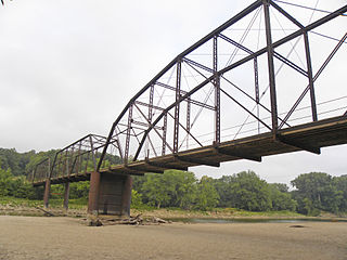
 Sutliff Bridge before its collapse
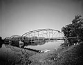
 Sutliff Bridge truss badly damaged in 2008 flood, downstream from bridge

