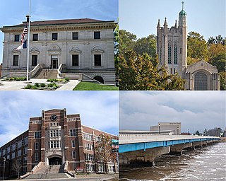
Ottumwa is a city in and the county seat of Wapello County, Iowa, United States. The population was 25,529 at the time of the 2020 U.S. Census. Located in the state's southeastern section, the city is split into northern and southern halves by the Des Moines River.
The Wisconsin Bridge and Iron Company (WB&I) was a fabricator and erector of iron and steel bridges and other large structures.
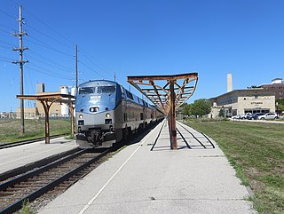
Ottumwa station is an Amtrak intercity train station in Ottumwa, Iowa, United States. The station was originally built by the Chicago, Burlington and Quincy Railroad, and has been listed as Burlington Depot by the National Register of Historic Places since November 26, 2008. It became a contributing property in the Historic Railroad District in 2011.

The Clinton Falls Bridge, also known as the Old Mill Bridge and formally as Bridge L-5573, is a historic steel Pratt through truss bridge that spans the Straight River in Clinton Falls Township, Minnesota. It was listed on the National Register of Historic Places in 1997 as Bridge No. L-5573 for having local significance in the theme of engineering. It was nominated for being an example of early steel truss bridge design in Minnesota.

The Court Avenue Bridge is a historic structure located in downtown Des Moines, Iowa, United States. It became a contributing property in the Civic Center Historic District in 1988, and was individually listed on the National Register of Historic Places on May 15, 1998 as a part of the Highway Bridges of Iowa MPS.
The Southwest Fifth St. Bridge is a historic structure located in downtown Des Moines, Iowa, United States. Built in 1898 after a controversy surrounding the bidding process, it is one of the last Pratt through truss bridges left in an urban setting in Iowa. The bridge was listed on the National Register of Historic Places in 1998 as a part of the Highway Bridges of Iowa MPS.
The River Street Bridge at Marble Rock, Iowa, also known as Richard W. "Dick" Weldon River Street Bridge, has the appearance of a being a filled spandrel deck arch bridge, but it is not. When it was built in 1912, concrete girders were relatively new, and this was built with straight ones in three 30-foot (9.1 m) sections, by the Miller-Hey Construction Company of Des Moines, in one of its first contracts. The straight girders carried the load, and it is a girder bridge. However this was given a touch of elegance by its arched spandrels, which usually appear above load-bearing arches in deck arch bridges.

The Pittsburgh-Des Moines Steel Company, and often referred to as Pitt-Des Moines Steel or PDM was an American steel fabrication company. It operated from 1892 until approximately 2002 when its assets were sold to other companies, including Chicago Bridge & Iron Company. The company began as a builder of steel water tanks and bridges. It also later fabricated the "forked" columns for the World Trade Center in the 1960s, and was the steel fabricator and erector for the Gateway Arch in St. Louis. A number of its works are listed on the National Register of Historic Places.

The Cascade Bridge is a historic structure located in Burlington, Iowa, United States. In April 1896 the Burlington City Council approved a proposal to have city engineer S.D. Eaton advertise for plans and estimates for a bridge on Main Street that would span Cascade Ravine. The Cascade Lumber Company had petitioned for the bridge. The city contracted with the Cedar Rapids, Iowa firm of Boynton & Warriner to design the structure and the Milwaukee Bridge and Iron Works to erect the span. The city was responsible for building the concrete substructure. The bridge was completed in the fall of 1896, and is composed of four spans. The span length is 160 feet (49 m), and its total length is 464 feet (141 m). The span is a Baltimore deck truss bridge with Pratt deck trusses at both ends. The structure is supported by stone and concrete abutments with concrete pedestals and a single concrete-filled steel cylinder pier. Over the years the original deck has been replaced, and concrete has been applied to the stone abutments. Otherwise the structure has been unaltered. The bridge was listed on the National Register of Historic Places in 1998.
The Boone Bridge was located southwest of Boone, Iowa, United States. It spanned the Des Moines River for 647 feet (197 m). The area in which this bridge was built was a pivotal transportation corridor in the early 20th century. The Chicago and North Western Railroad built the Boone Viaduct upstream from this location in 1901. It was the world's longest two-track viaduct. The county built a pin-connected truss bridge to carry a county road over the river just downstream from this location in 1909. In 1913 it was chosen as part of the route of the Lincoln Highway, the nation's first transcontinental highway. Because of its narrow width of only 16 feet (4.9 m) and an increase in traffic, a new bridge was required. The Iowa State Highway Commission designed this bridge in 1927. It was composed of two riveted Pratt and two Parker through trusses. The contract to build the structure was awarded in November 1927 to the A. Olson Construction Company of Waterloo, Iowa for $77,900. It was completed later in 1928. The bridge carried U.S. Route 30 traffic until it was rerouted to the south. It carried a county road until it was replaced in the early 21st century, and dismantled. The bridge was listed on the National Register of Historic Places in 1998.
The Rockwell City Bridge is located just east of Rockwell City, Iowa, United States. The 60-foot (18 m) span carried traffic on 270th Street over an unnamed stream. In 1915 Calhoun County requested the Iowa State Highway Commission (ISHC) and Des Moines engineer James B. Marsh to design a bridge for this crossing. The ISHC designed a double span concrete girder structure, while Marsh submitted his patented single-span rainbow arch configuration. They chose the Marsh submission, and contracted with the Iowa Bridge Company to build six bridges for $11,690, which included the costs for this bridge at $4,107.65. Originally built to serve a county road, it was later incorporated into the route for U.S. Highway 20 and carried heavy traffic until the highway was realigned in 1981. While no longer in use, the bridge remains in place just south of the replacement span. It was listed on the National Register of Historic Places in 1998.

The Kilbourn Bridge is located south of Kilbourn, Iowa, United States. It carried traffic on Lark Avenue over the Des Moines River for 855 feet (261 m). In 1890, the Van Buren County Board of Supervisors contracted with the Western Bridge Company of Chicago to build a bridge at the Kilbourn ferry crossing. It was destroyed in a flood in 1903, and the Board of Supervisors put off replacing the bridge until 1907, then all the proposals came over the $20,000 limit. They removed the limit the following year. The six-span bridge was designed by the Iowa State Highway Commission (ISHC), and built by the Ottumwa Supply and Construction Company of Ottumwa, Iowa. It was the first large-scale engineering project undertaken by the newly formed ISHC. The Kilbourn Bridge was listed on the National Register of Historic Places in 1998.

The Quechee Gorge Bridge is a historic bridge, carrying U.S. Route 4 (US 4) across Quechee Gorge, near the Quechee village of Hartford, Vermont. Built in 1911, it is Vermont's oldest surviving steel arch bridge. It was listed on the National Register of Historic Places in 1990.

The Mississquoi River Bridge is a steel truss bridge, spanning the Missisquoi River between Richford, Vermont and Sutton, Quebec on the Canada–United States border. It connects Chemin de la Vallée Missisquoi in Sutton with Vermont Route 105A in Richford, between the border stations of the East Richford–Glen Sutton Border Crossing. The bridge was built by the state of Vermont in 1929, and is one of two in the state built by the Pittsburgh-Des Moines Steel Company. It was listed on the United States National Register of Historic Places in 1990.

The Hassayampa Bridge is a bridge spanning the Hassayampa River in Hassayampa, Arizona, located in Maricopa County. The bridge was completed in 1929 and was listed on the National Register of Historic Places in 1988. The bridge was scheduled for demolition in 1983.
The Rock Falls Bridge is a historic structure located in Rock Falls, in the north-central part of the U.S. state of Iowa. The span carries Spring Street over the Shell Rock River for 142 feet (43 m). The Iowa State Highway Commission prepared the plans for this bridge in September 1928, and they were revised in February 1929. While they designed riveted steel trusses for medium-span bridges in rural areas, they used concrete open spandrel arches like this one for several urban and small town structures in the 1920s. C.A. Holvik of Mason City was awarded the contract to construct the bridge, which they completed later in 1929. It was listed on the National Register of Historic Places in 1998.
South Dakota Department of Transportation Bridge No. 63-198-181 was a historic bridge in rural Turner County, South Dakota, carrying 460th Avenue across the East Fork Vermillion River south of Davis. Built in 1909, it was a well-preserved example of bridges built for the county by the Iowa Bridge Company. It was listed on the National Register of Historic Places in 1999.

South Dakota Department of Transportation Bridge No. 63-210-282 was a historic bridge in rural Turner County, South Dakota, carrying 461st Avenue across the East Fork Vermillion River southwest of Centerville. Built in 1909, it was a well-preserved example of bridges built for the county by the Iowa Bridge Company. It was listed on the National Register of Historic Places in 1999. The bridge's original Pratt through main span was replaced by a steel girder span in 2009–10.

The Long Cove Creek railway viaducts are heritage-listed railway viaducts which carry the Main Suburban railway line over Long Cove Creek between the suburbs of Lewisham and Summer Hill in Sydney, New South Wales, Australia. The viaducts were designed and built by the New South Wales Government Railways. The property is owned by Transport Asset Holding Entity, an agency of the Government of New South Wales. It was added to the New South Wales State Heritage Register on 2 April 1999.
The Black River Bridge near Carrizo, Arizona was funded in 1911 and built in 1912. It was listed on the National Register of Historic Places in 1988. It spans the Black River, bringing an army road, now Indian Route 9, over the river from Fort Apache to the railroad at the former town of Rice, Arizona.


