Manilla, Iowa

Last updated

Manilla, Iowa
Manilla, IA.jpg
Main Street
Crawford County Iowa Incorporated and Unincorporated areas Manilla Highlighted.svg
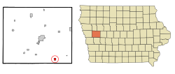
Location of Manilla, Iowa
Coordinates: 41°53′33″N95°14′04″W / 41.89250°N 95.23444°W / 41.89250; -95.23444
Country Flag of the United States.svg  United States
State Flag of Iowa.svg  Iowa
County Crawford
Area
[1]
  Total1.06 sq mi (2.75 km2)
  Land1.06 sq mi (2.75 km2)
  Water0.00 sq mi (0.00 km2)
Elevation
[2]
1,319 ft (402 m)
Population
 (2020)
  Total775
  Density729.07/sq mi (281.40/km2)
Time zone UTC-6 (Central (CST))
  Summer (DST) UTC-5 (CDT)
ZIP code
51454
Area code 712
FIPS code 19-48855
GNIS feature ID2395830 [2]

Manilla is a city in Crawford County, Iowa, United States, along the West Branch of the West Nishnabotna River. The population was 775 at the time of the 2020 census. [3]

Contents

History

Manilla is working to bolster its declining population by providing free land and property tax abatements to attract new residents. [4]

Geography

Aerial photo of Manilla, Iowa Manilla, Iowa aerial 02A.jpg
Aerial photo of Manilla, Iowa

According to the United States Census Bureau, the city has a total area of 1.03 square miles (2.67 km2), all land. [5]

Demographics

Historical populations
YearPop.±%
1890 526    
1900 773+47.0%
1910 875+13.2%
1920 1,142+30.5%
1930 1,032−9.6%
1940 1,040+0.8%
1950 1,035−0.5%
1960 939−9.3%
1970 943+0.4%
1980 1,020+8.2%
1990 898−12.0%
2000 839−6.6%
2010 776−7.5%
2020 775−0.1%
Source: "U.S. Census website". United States Census Bureau . Retrieved March 29, 2020. and Iowa Data Center
Source:
U.S. Decennial Census [6] [3]

2010 census

As of the census [7] of 2010, there were 776 people, 337 households, and 214 families living in the city. The population density was 753.4 inhabitants per square mile (290.9/km2). There were 369 housing units at an average density of 358.3 per square mile (138.3/km2). The racial makeup of the city was 97.9% White, 0.1% Asian, 1.2% from other races, and 0.8% from two or more races. Hispanic or Latino of any race were 2.6% of the population.

There were 337 households, of which 27.0% had children under the age of 18 living with them, 49.9% were married couples living together, 8.9% had a female householder with no husband present, 4.7% had a male householder with no wife present, and 36.5% were non-families. 33.5% of all households were made up of individuals, and 18.1% had someone living alone who was 65 years of age or older. The average household size was 2.18 and the average family size was 2.74.

The median age in the city was 47.7 years. 20.9% of residents were under the age of 18; 5.4% were between the ages of 18 and 24; 19.5% were from 25 to 44; 27.4% were from 45 to 64; and 26.7% were 65 years of age or older. The gender makeup of the city was 47.6% male and 52.4% female.

2000 census

As of the census [8] of 2000, there were 839 people, 337 households, and 222 families living in the city. The population density was 1,059.2 inhabitants per square mile (409.0/km2). There were 369 housing units at an average density of 465.8 per square mile (179.8/km2). The racial makeup of the city was 97.74% White, 0.24% African American, 0.36% from other races, and 1.67% from two or more races. Hispanic or Latino of any race were 0.48% of the population.

There were 337 households, out of which 27.3% had children under the age of 18 living with them, 56.7% were married couples living together, 7.1% had a female householder with no husband present, and 34.1% were non-families. 30.3% of all households were made up of individuals, and 17.5% had someone living alone who was 65 years of age or older. The average household size was 2.31 and the average family size was 2.89.

In the city, the population was spread out, with 22.8% under the age of 18, 6.8% from 18 to 24, 21.8% from 25 to 44, 21.1% from 45 to 64, and 27.5% who were 65 years of age or older. The median age was 44 years. For every 100 females, there were 90.2 males. For every 100 females age 18 and over, there were 86.2 males.

The median income for a household was $31,146, and the median income for a family was $37,625. Males had a median income of $27,292 versus $16,875 for females. The per capita income for the city was $14,011. About 10.5% of families and 12.1% of the population were below the poverty line, including 17.2% of those under age 18 and 7.0% of those age 65 or over.

Education

Manilla is served by the IKM–Manning Community School District. [9] The district previously operated a middle school in Manilla but it closed in 2014; at the time the district continued to have its headquarters there. [10]

The Manilla Community School District was formed as a consolidation of various area school districts in 1889, and a four classroom building served as the first school in the city. [11] In 1904 the first class graduated. [12] A new school building funded by a $45,000 bond opened in 1915. In 1956 the school was renamed the Manilla Community School. [11] On July 1, 1992, the Manilla district merged into the IKM Community School District. That in turn, on July 1, 2011, merged into IKM–Manning. [13]

Related Research Articles

<span class="mw-page-title-main">Crawford County, Iowa</span> County in Iowa, United States

Crawford County is a county located in the U.S. state of Iowa. As of the 2020 census, the population was 16,525. Its county seat is Denison. The county was named for William Harris Crawford, U.S. senator from Georgia and United States Secretary of the Treasury.

<span class="mw-page-title-main">Rembrandt, Iowa</span> City in Iowa, United States

Rembrandt is a city in Buena Vista County, Iowa, United States. The population was 209 at the time of the 2020 census.

<span class="mw-page-title-main">Bristow, Iowa</span> City in Iowa, United States

Bristow is a city in Butler County, Iowa, United States. The population was 145 at the 2020 census.

<span class="mw-page-title-main">Rinard, Iowa</span> City in Iowa, United States

Rinard is a city in Calhoun County, Iowa, United States. The population was 38 at the time of the 2020 census.

<span class="mw-page-title-main">Manning, Iowa</span> City in Iowa, United States

Manning is a city in Carroll County, Iowa, United States, along Iowa Highway 141. The population was 1,455 at the time of the 2020 census. It is named for Orlando Harrison Manning, a Lieutenant Governor of Iowa.

<span class="mw-page-title-main">Templeton, Iowa</span> City in Iowa, United States

Templeton is a city in Carroll County, Iowa, United States. The population was 352 at the time of the 2020 census.

<span class="mw-page-title-main">Thornton, Iowa</span> City in Iowa, United States

Thornton is a city in Cerro Gordo County, Iowa, United States. The population was 400 at the time of the 2020 census. It is part of the Mason City Micropolitan Statistical Area.

<span class="mw-page-title-main">Gillett Grove, Iowa</span> City in Iowa, United States

Gillett Grove is a city in Clay County, Iowa, United States. The population was 30 in the 2020 census, a decline from 55 in 2000.

<span class="mw-page-title-main">Aspinwall, Iowa</span> City in Iowa, United States

Aspinwall is a city in Crawford County, Iowa, United States. The population was 33 at the 2020 census.

<span class="mw-page-title-main">Charter Oak, Iowa</span> City in Iowa, United States

Charter Oak is a city in Crawford County, Iowa, United States, along the East Soldier River. The population was 535 at the 2020 census.

<span class="mw-page-title-main">Luxemburg, Iowa</span> City in Iowa, United States

Luxemburg is a city in Dubuque County, Iowa, United States. It is part of the Dubuque, Iowa Metropolitan Statistical Area. The population was 245 at the time of the 2020 census, down from 246 in 2000. The White Pine Hollow State Forest is located four miles to the northwest of Luxemburg.

<span class="mw-page-title-main">West Union, Iowa</span> City in Iowa, United States

West Union is a city in Fayette County, Iowa, United States. The population was 2,490 at the time of the 2020 census. It is the county seat of Fayette County.

<span class="mw-page-title-main">Imogene, Iowa</span> City in Iowa, United States

Imogene is a city in Fremont County, Iowa, United States. The population was 39 at the time of the 2020 census.

<span class="mw-page-title-main">Titonka, Iowa</span> City in Iowa, United States

Titonka is a city in Kossuth County, Iowa, United States. The population was 511 at the time of the 2020 census.

<span class="mw-page-title-main">Minden, Iowa</span> City in Iowa, United States

Minden is a city in Pottawattamie County, Iowa, United States. The population was 600 at the time of the 2020 census. It has possessed a post office since 1875.

<span class="mw-page-title-main">Neola, Iowa</span> City in Iowa, United States

Neola is a city in Pottawattamie County, Iowa, United States. The population was 918 at the time of the 2020 census.

<span class="mw-page-title-main">Irwin, Iowa</span> City in Iowa, United States

Irwin is a city in Shelby County, Iowa, United States, along the West Nishnabotna River. The population was 319 at the time of the 2020 census.

<span class="mw-page-title-main">Kirkman, Iowa</span> City in Iowa, United States

Kirkman is a city in Shelby County, Iowa, United States, along the West Nishnabotna River. The population was 56 at the time of the 2020 census.

<span class="mw-page-title-main">Gilbert, Iowa</span> City in Iowa, United States

Gilbert is a city in Story County, Iowa, United States. The population was 1,211 at the time of the 2020 census. It is part of the Ames, Iowa Metropolitan Statistical Area, which is a part of the larger Ames-Boone, Iowa Combined Statistical Area.

<span class="mw-page-title-main">McCallsburg, Iowa</span> City in Iowa, United States

McCallsburg is a city in Story County, Iowa, United States. The population was 353 at the time of the 2020 census. It is part of the Ames, Iowa Metropolitan Statistical Area, which is a part of the larger Ames-Boone, Iowa Combined Statistical Area.

References

  1. "2020 U.S. Gazetteer Files". United States Census Bureau. Retrieved March 16, 2022.
  2. 1 2 U.S. Geological Survey Geographic Names Information System: Manilla, Iowa
  3. 1 2 "2020 Census State Redistricting Data". census.gov. United states Census Bureau. Retrieved August 12, 2021.
  4. Kilen, Mike. "Free land the key to small towns' growth?" The Des Moines Register, November 15, 2009.
  5. "US Gazetteer files 2010". United States Census Bureau. Archived from the original on January 25, 2012. Retrieved May 11, 2012.
  6. "Census of Population and Housing". Census.gov. Retrieved June 4, 2015.
  7. "U.S. Census website". United States Census Bureau . Retrieved May 11, 2012.
  8. "U.S. Census website". United States Census Bureau . Retrieved January 31, 2008.
  9. "IKM-Manning." Iowa Department of Education. Retrieved on July 17, 2018.
  10. "When schools close". Carroll Daily Times Herald . March 28, 2014. Archived from the original on July 17, 2018. Retrieved July 17, 2018.
  11. 1 2 "Chronology of Education." City of Manilla. Retrieved on July 17, 2018.
  12. Forbes, Greg (February 18, 2014). "IKM-Manning school board advised to close Manilla building". Bulletin-Review . Retrieved July 27, 2023.
  13. "REORGANIZATION & DISSOLUTION ACTIONS SINCE 1965-66." Iowa Department of Education. Retrieved on July 20, 2018.