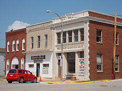
Oxford Junction, Iowa

Last updated
Oxford Junction, Iowa
Oxford Junction, Iowa.JPG
Motto: 
"The junction of opportunity"
Jones County Iowa Incorporated and Unincorporated areas Oxford Junction Highlighted.svg
Location of Oxford Junction, Iowa
Coordinates: 41°59′00″N90°57′16″W / 41.98333°N 90.95444°W / 41.98333; -90.95444
Country Flag of the United States.svg  United States
State Flag of Iowa.svg  Iowa
County Jones
Area
[1]
  Total0.65 sq mi (1.68 km2)
  Land0.65 sq mi (1.68 km2)
  Water0.00 sq mi (0.00 km2)
Elevation
732 ft (223 m)
Population
 (2020)
  Total424
  Density654.32/sq mi (252.67/km2)
Time zone UTC-6 (Central (CST))
  Summer (DST) UTC-5 (CDT)
ZIP code
52323
Area code 563
FIPS code 19-60690
GNIS feature ID0459977

Oxford Junction is a city in Jones County, Iowa, United States. The population was 424 at the time of the 2020 census. [2] It is part of the Cedar Rapids Metropolitan Statistical Area.

Contents

History

Oxford Junction was platted in 1871, at the time the now-defunct railroad was built. The town is named for its location at the junction of two branches of the Chicago, Milwaukee, St. Paul and Pacific Railroad. [3]

Geography

Oxford Junction is located at 41°59′00″N90°57′16″W / 41.983203°N 90.954480°W / 41.983203; -90.954480 Coordinates: 41°59′00″N90°57′16″W / 41.983203°N 90.954480°W / 41.983203; -90.954480 (41.983203, -90.954480). [4]

According to the United States Census Bureau, the city has a total area of 0.69 square miles (1.79 km2), all land. [5]

Demographics

Historical populations
YearPop.±%
1880 349    
1890 752+115.5%
1900 780+3.7%
1910 822+5.4%
1920 807−1.8%
1930 759−5.9%
1940 705−7.1%
1950 663−6.0%
1960 725+9.4%
1970 666−8.1%
1980 600−9.9%
1990 581−3.2%
2000 573−1.4%
2010 496−13.4%
2020 424−14.5%
Source: "U.S. Census website". United States Census Bureau . Retrieved 2020-03-29. and Iowa Data Center
Source:
U.S. Decennial Census [6] [2]

2010 census

At the 2010 census there were 496 people, 223 households, and 141 families living in the city. The population density was 718.8 inhabitants per square mile (277.5/km2). There were 262 housing units at an average density of 379.7 per square mile (146.6/km2). The racial makup of the city was 99.0% White, 0.6% Native American, and 0.4% Asian. [7] Of the 223 households 26.0% had children under the age of 18 living with them, 46.2% were married couples living together, 13.0% had a female householder with no husband present, 4.0% had a male householder with no wife present, and 36.8% were non-families. 31.8% of households were one person and 18.4% were one person aged 65 or older. The average household size was 2.22 and the average family size was 2.75.

The median age was 45.5 years. 22.2% of residents were under the age of 18; 7.4% were between the ages of 18 and 24; 19% were from 25 to 44; 29.2% were from 45 to 64; and 22.2% were 65 or older. The gender makeup of the city was 50.0% male and 50.0% female.

2000 census

At the 2000 census there were 573 people, 236 households, and 151 families living in the city. The population density was 813.3 inhabitants per square mile (314.0/km2). There were 264 housing units at an average density of 374.7 per square mile (144.7/km2). The racial makup of the city was 98.95% White, 0.17% Native American, 0.17% Asian, and 0.70% from two or more races. Hispanic or Latino of any race were 0.17%. [8]

Of the 236 households 33.5% had children under the age of 18 living with them, 50.4% were married couples living together, 7.6% had a female householder with no husband present, and 36.0% were non-families. 32.6% of households were one person and 22.9% were one person aged 65 or older. The average household size was 2.43 and the average family size was 3.09.

The age distribution was 27.2% under the age of 18, 8.0% from 18 to 24, 24.1% from 25 to 44, 19.7% from 45 to 64, and 20.9% 65 or older. The median age was 39 years. For every 100 females, there were 89.1 males. For every 100 females age 18 and over, there were 84.5 males.

The median household income was $30,417 and the median family income was $35,625. Males had a median income of $26,875 versus $17,333 for females. The per capita income for the city was $13,805. About 18.5% of families and 18.9% of the population were below the poverty line, including 24.0% of those under age 18 and 12.1% of those age 65 or over.

Education

It is within the Midland Community School District and hosts the district's sole elementary school. [9] The Oxford Junction district merged into the Midland district on July 1, 1995. [10]

Notable people

Related Research Articles

<span class="mw-page-title-main">Rinard, Iowa</span> City in Iowa, United States

Rinard is a city in Calhoun County, Iowa, United States. The population was 38 at the time of the 2020 census.

<span class="mw-page-title-main">Lanesboro, Iowa</span> City in Iowa, United States

Lanesboro is a city in Carroll County, Iowa, United States. The population was 119 at the time of the 2020 census.

<span class="mw-page-title-main">Grand River, Iowa</span> City in Iowa, United States

Grand River is a city in northwest Decatur County, Iowa, United States. The population was 196 at the time of the 2020 census.

<span class="mw-page-title-main">Van Wert, Iowa</span> City in Iowa, United States

Van Wert is a city in northern Decatur County, Iowa, United States. The population was 178 at the time of the 2020 census.

<span class="mw-page-title-main">Paton, Iowa</span> City in Iowa, United States

Paton is a city in Greene County, Iowa, United States. The population was 221 at the time of the 2020 census.

<span class="mw-page-title-main">Wyoming, Iowa</span> City in Iowa, United States

Wyoming is a city in Jones County, Iowa, United States. The population was 523 at the time of the 2020 census. It is part of the Cedar Rapids Metropolitan Statistical Area.

<span class="mw-page-title-main">Thornburg, Iowa</span> City in Iowa, United States

Thornburg is a village in Keokuk County, Iowa, United States. The population was 45 at the time of the 2020 census. Its sole enterprise is the Tri-County Community School, a public school serving grades K-12.

<span class="mw-page-title-main">Columbus City, Iowa</span> City in Iowa, United States

Columbus City is a city in western Louisa County, Iowa, United States. The population was 392 at the 2020 census. It is part of the Muscatine Micropolitan Statistical Area.

<span class="mw-page-title-main">Cotter, Iowa</span> City in Iowa, United States

Cotter is a city in western Louisa County, Iowa, United States. The population was 39 at the 2020 census. It is part of the Muscatine Micropolitan Statistical Area.

<span class="mw-page-title-main">Macksburg, Iowa</span> City in Iowa, United States

Macksburg is a city in Madison County, Iowa, United States. The population was 97 at the time of the 2020 census. It is part of the Des Moines–West Des Moines Metropolitan Statistical Area.

<span class="mw-page-title-main">Patterson, Iowa</span> City in Iowa, United States

Patterson is a city in Madison County, Iowa, United States. The population was 176 at the time of the 2020 census. It is part of the Des Moines–West Des Moines Metropolitan Statistical Area.

<span class="mw-page-title-main">Gilman, Iowa</span> City in Iowa, United States

Gilman is a city in the southeastern corner of Marshall County, Iowa, United States. The population was 542 at the time of the 2020 census.

<span class="mw-page-title-main">Mallard, Iowa</span> City in Iowa, United States

Mallard is a city in Palo Alto County, Iowa, United States. The population was 257 at the time of the 2020 census.

<span class="mw-page-title-main">Havelock, Iowa</span> City in Iowa, United States

Havelock is a city in Pocahontas County, Iowa, United States. The population was 130 at the time of the 2020 census.

<span class="mw-page-title-main">Maloy, Iowa</span> City in Iowa, United States

Maloy is a city in southwest Ringgold County, Iowa, United States, along the Platte River. The population was 22 at the time of the 2020 census.

<span class="mw-page-title-main">Westphalia, Iowa</span> City in Iowa, United States

Westphalia is a city in Shelby County, Iowa, United States. The population was 126 at the time of the 2020 census.

<span class="mw-page-title-main">Spring Hill, Iowa</span> City in Iowa, United States

Spring Hill is a city in Warren County, Iowa, United States. The population was 68 at the time of the 2020 census. It is part of the Des Moines–West Des Moines Metropolitan Statistical Area.

<span class="mw-page-title-main">St. Marys, Iowa</span> City in Iowa, United States

St. Marys is a city in Warren County, Iowa, United States. The population was 108 at the time of the 2020 census.

<span class="mw-page-title-main">Crawfordsville, Iowa</span> City in Iowa, United States

Crawfordsville is a city in Washington County, Iowa, United States. It is part of the Iowa City, Iowa Metropolitan Statistical Area. The population was 277 at the 2020 census.

<span class="mw-page-title-main">West Chester, Iowa</span> City in Iowa, United States

West Chester is a city in Washington County, Iowa, United States. It is part of the Iowa City, Iowa Metropolitan Statistical Area. The population was 144 at the time of the 2020 census.

References

  1. "2020 U.S. Gazetteer Files". United States Census Bureau. Retrieved March 16, 2022.
  2. 1 2 "2020 Census State Redistricting Data". census.gov. United states Census Bureau. Retrieved 12 August 2021.
  3. Corbit, Robert McClain (1910). History of Jones County, Iowa: Past and Present, Volume 1. S. J. Clarke Publishing Company. p. 503.
  4. "US Gazetteer files: 2010, 2000, and 1990". United States Census Bureau. 2011-02-12. Retrieved 2011-04-23.
  5. "US Gazetteer files 2010". United States Census Bureau. Archived from the original on 2012-01-25. Retrieved 2012-05-11.
  6. "Census of Population and Housing". Census.gov. Retrieved June 4, 2015.
  7. "U.S. Census website". United States Census Bureau . Retrieved 2012-05-11.
  8. "U.S. Census website". United States Census Bureau . Retrieved 2008-01-31.
  9. "Midland" (PDF). Iowa Department of Education . Retrieved 2020-03-26.
  10. "REORGANIZATION & DISSOLUTION ACTIONS SINCE 1965-66" (PDF). Iowa Department of Education. Archived from the original (PDF) on 2019-02-09. Retrieved 2020-03-22.