Canton, Iowa | |
|---|---|
 Canton  Canton | |
| Coordinates: 42°09′48″N90°53′45″W / 42.16333°N 90.89583°W | |
| Country | United States |
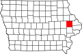
| State | Iowa |
| Counties | Jackson, Jones |
| Elevation | 728 ft (222 m) |
| Time zone | UTC-6 (Central (CST)) |
| • Summer (DST) | UTC-5 (CDT) |
| Area code | 563 |
| GNIS feature ID | 455154 [1] |
Canton is an unincorporated community in Jackson and Jones counties, Iowa, United States. [1]