Related Research Articles

Heritage Documentation Programs (HDP) is a division of the U.S. National Park Service (NPS) responsible for administering the Historic American Buildings Survey (HABS), Historic American Engineering Record (HAER), and Historic American Landscapes Survey (HALS). These programs were established to document historic places in the United States. Records consist of measured drawings, archival photographs, and written reports, and are archived in the Prints and Photographs Division of the Library of Congress.
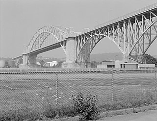
The McKees Rocks Bridge is a steel trussed through arch bridge which carries the Blue Belt, Pittsburgh's innermost beltline, across the Ohio River at Brighton Heights and McKees Rocks, Pennsylvania, west of the city.

The Williamstown Bridge is a bridge over the Ohio River between Williamstown, West Virginia, and Marietta, Ohio. The bridge carries West Virginia Route 31 and Ohio State Route 60. U.S. Route 21 was also formerly routed along this bridge.

The Parkersburg–Belpre Bridge is a four-lane cantilever bridge that connects Parkersburg, West Virginia to Belpre, Ohio across the Ohio River. The bridge was completed in 1980. The bridge had been signed U.S. Route 50 (US 50) until June 13, 2008, when that highway was re-routed to the Blennerhassett Island Bridge a few miles to the west, as part of the completion of the Corridor D project around Parkersburg. The American Discovery Trail uses the bridge to cross the Ohio River.
The Parkersburg Bridge crosses the Ohio River between Parkersburg, West Virginia, and Belpre, Ohio. Designed by Jacob Linville, the bridge has 46 spans: 25 deck plate girder, 14 deck truss, 6 through truss, and 1 through plate girder. 50,000 cubic yards (38,000 m3) of stone were used for the 53 piers. The bridge was constructed from May 1869 to January 1871 by the Baltimore and Ohio Railroad. At the time of its completion, the bridge was reportedly the longest in the world at 7,140 feet (2,180 m).
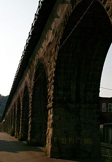
B & O Railroad Viaduct is a historic structure in Bellaire, Ohio, listed in the National Register of Historic Places on June 22, 1976.

The B & O Railroad Potomac River Crossing is a 15-acre (6.1 ha) historic site where a set of railroad bridges, originally built by the Baltimore and Ohio Railroad, span the Potomac River between Sandy Hook, Maryland, and Harpers Ferry, West Virginia, in the United States. The site was added to the National Register of Historic Places on February 14, 1978 for its significance in commerce, engineering, industry, invention, and transportation.
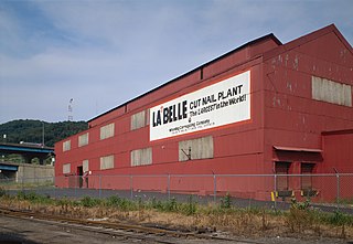
La Belle Iron Works, also known as La Belle Cut Nail Works, was a historic factory complex and national historic district located at Wheeling, Ohio County, West Virginia. The district included four contributing buildings; three Italianate style brick buildings dated to the founding of the company in 1852, and a tin plate mill built 1894–1897. After 1902, the buildings were combined under a single roof, although the truss systems date to different periods achieving the configuration visible today. When listed in 1997, it was known as the "La Belle Cut Nail Plant, The Largest in the World, Wheeling Corrugating Company, A Division of Wheeling Pittsburgh Steel Corporation." The cut nail machinery still in use by La Belle dated to 1852 and the 1860s. The machinery at La Belle along with the different processes were documented by the Historic American Buildings Survey team during the summer of 1990.