This is a list of bridges documented by the Historic American Engineering Record in the U.S. state of Vermont. [1]

Marsh-Billings-Rockefeller National Historical Park is a United States National Historical Park in Woodstock, Vermont. The park preserves the Marsh-Billings House, as well as the site where Frederick Billings established a managed forest and a progressive dairy farm. The name honors Billings and the other owners of the property: George Perkins Marsh, Mary Montagu Billings French, Laurance Rockefeller, and Mary French Rockefeller. The Rockefellers transferred the property to the federal government in 1992. It is the only unit of the United States National Park System in Vermont.

Heritage Documentation Programs (HDP) is a division of the U.S. National Park Service (NPS) responsible for administering the Historic American Buildings Survey (HABS), Historic American Engineering Record (HAER), and Historic American Landscapes Survey (HALS). These programs were established to document historic places in the United States. Records consist of measured drawings, archival photographs, and written reports, and are archived in the Prints and Photographs Division of the Library of Congress.

Rhode Island Avenue is a diagonal avenue in the Northwest and Northeast quadrants of Washington, D.C. and the capital's inner suburbs in Prince George's County, Maryland. Paralleling New York Avenue, Rhode Island Avenue was one of the original streets in Pierre L'Enfant's plan for the capital. It became a major commuter route, carrying U.S. Route 1 traffic into the city from Prince George's County.

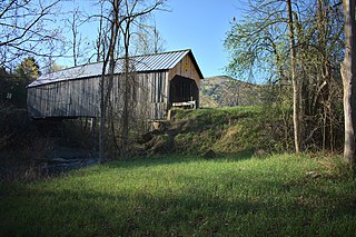
The Brown Covered Bridge is a wooden covered bridge in Shrewsbury, Vermont. Located in the northwestern part of the town, it carries Upper Cold River Road over the Cold River. It was closed to vehicular traffic in 2011 due to damage from Hurricane Irene and reopened as a National Historic Site on July 5, 2016. Built in 1880 by noted Vermont bridgewright Nichols M. Powers, it was designated a National Historic Landmark in 2014, cited as one of the finest and least-altered examples of a Town lattice truss covered bridge in the United States.

The steamboat Ticonderoga is one of two remaining side-paddle-wheel passenger steamers with a vertical beam engine of the type that provided freight and passenger service on America's bays, lakes and rivers from the early 19th to the mid-20th centuries. Commissioned by the Champlain Transportation Company, Ticonderoga was built in 1906 at the Shelburne Shipyard in Shelburne, Vermont on Lake Champlain.

The Cornish–Windsor Covered Bridge is a 155-year-old, two-span, timber Town lattice-truss, interstate, covered bridge that crosses the Connecticut River between Cornish, New Hampshire, and Windsor, Vermont. Until 2008, when the Smolen–Gulf Bridge opened in Ohio, it had been the longest covered bridge in the United States.

Old Blenheim Bridge was a wooden covered bridge that spanned Schoharie Creek in North Blenheim, New York, United States. With an open span of 210 feet (64 m), it had the second longest span of any surviving single-span covered bridge in the world. The 1862 Bridgeport Covered Bridge in Nevada County, California, currently undergoing repairs due to 1986 flooding is longer overall at 233 feet (71 m) but is argued to have a 208 feet (63 m) clear span. The bridge, opened in 1855, was also one of the oldest of its type in the United States. It was destroyed by flooding resulting from Tropical Storm Irene in 2011. Rebuilding of the bridge commenced in 2017 and was completed in 2018.

The Bellows Falls Arch Bridge was a three-hinged steel through arch bridge over the Connecticut River between Bellows Falls, Vermont and North Walpole, New Hampshire. It was structurally significant as the longest arch bridge in the United States when it was completed in 1905.

The Pulp Mill Covered Bridge, also called the Paper Mill Covered Bridge, is a wooden covered bridge that crosses Otter Creek between Middlebury and Weybridge, Vermont on Seymour Street. It was listed on the National Register of Historic Places in 1974.

The Pine Brook Covered Bridge, also called the Wilder Covered Bridge, is a wooden covered bridge that crosses Pine Brook in Waitsfield, Vermont on North Road. Built in 1872, it is one two surviving 19th-century covered bridges in the town. It was listed on the National Register of Historic Places in 1974.

The Great Eddy Covered Bridge, also called the Big Eddy Covered Bridge or Waitsfield Covered Bridge, is a wooden covered bridge that crosses the Mad River in Waitsfield, Vermont on Bridge Street. Built in 1833, it is one of Vermont's oldest covered bridges. It was listed on the National Register of Historic Places in 1974.

The Morgan Covered Bridge, also known as the Upper Covered Bridge is a wooden covered bridge that crosses the North Branch Lamoille River in Belvidere, Vermont on Morgan Bridge Road. Built about 1887, it is one of two covered bridges in Belvidere, and one of five in a five-mile span that all cross the same river. It was listed on the National Register of Historic Places in 1974.
The Flint Covered Bridge is a historic covered bridge carrying Bicknell Hill Road over the First Branch White River in northern Tunbridge, Vermont. Built in 1845, it is the oldest of five 19th-century covered bridges in Tunbridge, representing one of the highest concentrations of covered bridges in the state. It was listed on the National Register of Historic Places on September 10, 1974.

The Hall Covered Bridge, located in southern Rockingham, Vermont, carries Hall Bridge Road across the Saxtons River, just north of its junction with Vermont Route 121. It is a Town lattice truss bridge, built in 1982 as a replica of a circa-1867 bridge that was destroyed by an overweight truck in 1980. The bridge was listed on the National Register of Historic Places in 1973.

Best's Covered Bridge(akaSwallow's Bridge) is a historic covered bridge in West Windsor, Vermont, that carries Churchill Road over Mill Creek, just south of Vermont Route 44. Built in 1889, it is an architecturally distinctive laminated arch structure with a post-and-beam superstructure. It was listed on the National Register of Historic Places in 1973.

The Taftsville Covered Bridge is a timber-framed covered bridge which spans the Ottauquechee River in the Taftsville village of Woodstock, Vermont, in the United States. Built in 1836 and exhibiting no influence from patented bridge designs, it is among the oldest remaining covered bridges both in Vermont and the nation as a whole.

The East Shoreham Covered Railroad Bridge is a historic covered bridge spanning the Lemon Fair River near East Shoreham, Vermont. Built in 1897 by the Rutland Railroad Company, it is the state's only surviving example of a wooden Howe truss railroad bridge. It was listed on the National Register of Historic Places in 1974.

The Jeffersonville Bridge is a steel girder bridge carrying Vermont Route 108 across the Lamoille River, just north of the village of Jeffersonville, Vermont. It was built in 2014, replacing a Parker through truss bridge built in 1931; the latter bridge was listed on the National Register of Historic Places in 1991.
![]() Media related to Historic American Engineering Record images of Vermont at Wikimedia Commons
Media related to Historic American Engineering Record images of Vermont at Wikimedia Commons