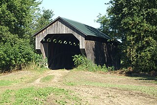
The Brown Covered Bridge is a wooden covered bridge in Shrewsbury, Vermont. Located in the northwestern part of the town, it carries Upper Cold River Road over the Cold River. It was closed to vehicular traffic in 2011 due to damage from Hurricane Irene and reopened on July 5, 2016. Built in 1880 by noted Vermont bridgewright Nichols M. Powers, it was designated a National Historic Landmark in 2014, cited as one of the finest and least-altered examples of a Town lattice truss covered bridge in the United States.

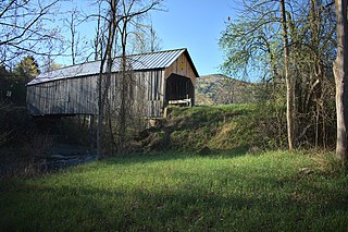
The Kingsley Covered Bridge is a wooden covered bridge carrying East Street across the Mill River in Clarendon, Vermont. Built about 1870, it is the town's only surviving 19th-century covered bridge. The bridge was listed on the National Register of Historic Places in 1974.

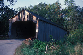
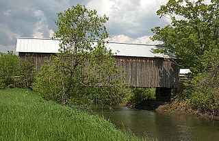
Gold Brook Covered Bridge, also known as Stowe Hollow Bridge or Emily's Bridge, is a small wooden covered bridge in the town of Stowe, Lamoille County, Vermont, carrying Covered Bridge Road over Gold Brook. Built in 1844, it is the only 19th-century covered bridge in the state built using wooden Howe trusses and carrying a public roadway. It was added to the National Register of Historic Places in 1974.
The Gates Farm Covered Bridge is a covered bridge that crosses the Seymour River off State Route 15 in Cambridge, Vermont. Built in 1897, it is last bridge to be built during the historic period of covered bridge construction with the Burr arch design. It was listed on the National Register of Historic Places in 1974.

The East Fairfield Covered Bridge is a covered bridge that carries Bridge Street across Black Creek in the East Fairfield village of Fairfield, Vermont. Built about 1865, it is the town's only surviving 19th century covered bridge. It was listed on the National Register of Historic Places in 1974.

The Grist Mill Covered Bridge, also known as the Scott Covered Bridge, the Bryant Covered Bridge, and the Canyon Covered Bridge, is a covered bridge that carries Canyon Road across the Brewster River, off Vermont Route 108 in Cambridge, Vermont. Built in the 19th century, it is one of a small number of surviving Burr arch truss bridges in the state, and is one of three left in Cambridge. It was listed on the National Register of Historic Places in 1974.

The Cedar Swamp Covered Bridge, also known as the Station Bridge and by various other names, was a historic wooden covered bridge spanning Otter Creek between Cornwall and Salisbury, Vermont. The Town lattice truss bridge was built in 1864-1865 and added to the National Register of Historic Places in 1974. It was destroyed by fire in September 2016.

The Halpin Covered Bridge, also called the High Covered Bridge, is a wooden covered bridge carrying Halpin Bridge Road across the Muddy Branch of the New Haven River in Middlebury, Vermont. It was listed on the National Register of Historic Places in 1974.

The Pine Brook Covered Bridge, also called the Wilder Covered Bridge, is a wooden covered bridge that crosses Pine Brook in Waitsfield, Vermont on North Road. Built in 1872, it is one two surviving 19th-century covered bridges in the town. It was listed on the National Register of Historic Places in 1974.

The Morgan Covered Bridge, also known as the Upper Covered Bridge is a wooden covered bridge that crosses the North Branch Lamoille River in Belvidere, Vermont on Morgan Bridge Road. Built about 1887, it is one of the two covered bridges in Belvidere, and one of five in a five-mile span that all cross the same river. It was listed on the National Register of Historic Places in 1974.
The Flint Covered Bridge is a historic covered bridge carrying Bicknell Hill Road over the First Branch White River in northern Tunbridge, Vermont. Built in 1845, it is the oldest of five 19th-century covered bridges in Tunbridge, representing one of the highest concentrations of covered bridges in the state. It was listed on the National Register of Historic Places on September 10, 1974.

The Fisher Covered Railroad Bridge is a covered bridge in Wolcott, Vermont. Built in 1908, it originally carried the St. Johnsbury and Lamoille County Railroad line over the Lamoille River. Now closed, it was the last covered bridge in Vermont to carry railroad traffic, and is a rare surviving example in the state of a double Town lattice truss. It was listed on the National Register of Historic Places in 1974.

The Dean Covered Bridge was a Town lattice truss covered bridge, carrying Union Street across Otter Creek in Brandon, Vermont. Built in 1840, it was one of Vermont's oldest covered bridges at the time of its destruction in 1986 by an arsonist. It was listed on the National Register of Historic Places, and was replaced by a modern steel and concrete bridge.

The Depot Covered Bridge is a historic Town lattice truss bridge, carrying Depot Hill Road over Otter Creek in Pittsford, Vermont. The bridge was built about 1840, and is one of Vermont's older covered bridges. It underwent restoration in the 1980s, and was subsequently reinforced with steel stringers. It was listed on the National Register of Historic Places in 1974.
The Sanderson Covered Bridge is a historic covered bridge, which carries Pearl Street over Otter Creek in Brandon, Vermont. Built about 1840, it is one of Vermont's oldest covered bridges, and is the only remaining 19th century bridge in Brandon. It was listed on the National Register of Historic Places in 1974.
The Howe Covered Bridge is a historic covered bridge carrying Belknap Brook Road across the White River in Tunbridge, Vermont, just east of Vermont Route 110. Built in 1879, it is one of five surviving bridges in the town, one of the highest concentrations of covered bridges in the state. It was listed on the National Register of Historic Places in 1974.

The Mill Covered Bridge is a replica historic covered bridge carrying Spring Road across the First Branch White River in Tunbridge, Vermont. It was built in 2000, nearly replicating a previous structure built on the site in 1883 and lost due to ice damage. It is one of a high concentration of covered bridges in Tunbridge and Chelsea. The 1883 bridge was listed on the National Register of Historic Places in 1974.

The Martin Covered Bridge is a wooden covered bridge spanning the Winooski River off United States Route 2 in southern Marshfield, Vermont. Built about 1890, it is the only surviving historic covered bridge in the town. It was listed on the National Register of Historic Places in 1974.

The Burrington Covered Bridge is a historic queenpost truss covered bridge in Lyndon, Vermont. Built in the 19th century, it is one of five covered bridges in Lyndon. It formerly carried Burrington Bridge Road across the Passumpsic River; it has been bypassed by a modern bridge. It was listed on the National Register of Historic Places in 1974.

The Centre Covered Bridge, also known as the Sanborn Covered Bridge, is a historic covered bridge, spanning the Passumpsic River next to U.S. Route 5 (US 5) north of the village of Lyndonville, Vermont. Built in 1872, it was moved to its present location and taken out of service in 1960. The bridge was located on Center Street between Lyndonville and Lyndon Center. It is one of three surviving Paddle-Ford truss bridges in Vermont. It was listed on the National Register of Historic Places in 1974. An amended National Register of Historic Places registration form was accepted by the National Park Service in 2024. The amendment fully documents the history and significance of the Centre Covered Bridge and lists it at the national level of significance.