Springfield is a historic neighborhood of Jacksonville, Florida, United States, located to the north of downtown. Established in 1869, it experienced its greatest growth from the early 1880s through the 1920s. The Springfield Historic District is listed in the National Register of Historic Places, and contains some of the city's best examples of 19th and early 20th century architecture.
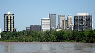
Tulsa is the second-largest city in the state of Oklahoma. It has many diverse neighborhoods due to its size.

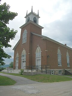
The Lummus Park Historic District or simply Lummus Park, is on the National Register of Historic Places and a locally historic designated district in Miami, Florida. It is roughly bound by Northwest Fifth Street to the north, Flagler Street to the south, Northwest Third Avenue to the east, and the Miami River to the west. On October 25, 2006, it was added to the U.S. National Register of Historic Places. Lummus Park has some of the oldest structures in Miami, and over the decades, has been able to retain a large part of its early pioneer character.
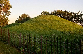
Dayton's Bluff is a neighborhood located on the east side of the Mississippi River in the southeast part of the city of Saint Paul, Minnesota which has a large residential district on the plateau extending backward from its top. The name of the bluff commemorates Lyman Dayton, for whom a city in Hennepin County was also named. On the edge of the southern and highest part of Dayton's bluff, in Indian Mounds Park, is a series of seven large aboriginal mounds, 4 to 18 feet high, that overlook the river and the central part of the city.
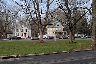
The Washington Street Historic District encompasses a residential area of Middletown, Connecticut that has a long history as a fashionable and desirable neighborhood. Extending along Washington Street and Washington Terrace between Main and Jackson Streets, the area has a broad diversity of residential architecture dating from 1752 to 1931, reflecting the city's patterns of growth. The district was listed on the National Register of Historic Places in 1985.

The Barre Downtown Historic District encompasses the historic commercial and civic heart of the city of Barre, Vermont. Extending along Main Street from City Park to Depot Square, this area was developed quite rapidly in the 1880s and 1890s, when the area experienced rapid growth due to the expansion of the nearby granite quarries. It was listed on the National Register of Historic Places in 1979.

The Canal Street–Clark Street Neighborhood Historic District encompasses a compact 19th-century working-class neighborhood of Brattleboro, Vermont. Most of its buildings are modest vernacular wood-frame buildings, erected between 1830 and 1935; there are a few apartment blocks, and one church. The district was listed on the National Register of Historic Places in 1993.
The Whitingham Village Historic District encompasses much of the current village center of Whitingham, Vermont. It was developed mainly in the second half of the 19th century around industries powered by local water sources, and includes well-preserved architecture from that period. It was listed on the National Register of Historic Places in 2006.
The Pittsford Green Historic District encompasses the heart of the traditional village center of Pittsford, Vermont. Centered on a stretch of United States Route 7, the village's development began in the late 18th century, and now consists almost entirely of buildings from the 19th century. The district was listed on the National Register of Historic Places in 1982.

The Poultney Main Street Historic District encompasses the commercial and residential historic core of the village of Poultney, Vermont. Centered on Main Street and East Main Street, between College Avenue and St. Raphael's Catholic Church, the district includes a diversity of architectural styles, as well as civic, religious, and commercial functions spanning a period of more than 100 years. The district was listed on the National Register of Historic Places in 1988.

The Wallingford Main Street Historic District encompasses the historic portions of the village of Wallingford, Vermont. An essentially linear district extending along Main Street on either side of School Street, it has a well-preserved array of 19th and early-20th century residential, commercial, and civic buildings. It was listed on the National Register of Historic Places in 1984.

The Vergennes Historic District encompasses the historic commercial and industrial heart of the city of Vergennes, Vermont. Incorporated in 1788, the city developed as a major industrial center, and served as a military center during the War of 1812. The district includes mainly 19th and early-20th century commercial, retail, residential and civic properties, as well as the former site of the Monkton Iron Works, once one of the nation's largest iron foundries. The district was listed on the National Register of Historic Places in 1976.

The Chelsea Village Historic District encompasses the historic village center of Chelsea, Vermont, the shire town of Orange County. Developed in the first half of the 19th century as a regional service and transportation hub, the village exhibits a significant number of Greek Revival buildings, augmented with primarily later civic and commercial buildings. It was listed on the National Register of Historic Places in 1983.

The Main Street–College Street Historic District encompasses a historically fashionable residential area of Burlington, Vermont. Principally located along Main and College Streets between South Winooski and South Williams Streets, the area was one of the city's most exclusive residential areas from the early 19th century to the early 20th century, and includes a diversity of high quality architecture from that period. It was listed on the National Register of Historic Places in 1988.

The Waterbury Village Historic District encompasses most of the central commercial and residential area of Waterbury, Vermont. Located along United States Route 2 and Stowe Street south of Thatcher Branch of the Winooski River, the sprawling village has been shaped by changes in transportation in the 19th and 20th centuries, and by key economic developments such as the founding of the Vermont State Hospital, which anchors the village's southern end. The district was listed on the National Register of Historic Places in 1978.

The South Union Street Historic District encompasses a historic 19th-century residential neighborhood for the upper middle class in Burlington, Vermont. Developed along South Union Street between Main and Howard Streets, South Union grew between about 1835 and 1938 as a popular area for well-to-do yet middle class Burlingtonians, affording views of Lake Champlain to the west. The architecturally diverse district was listed on the National Register of Historic Places in 1988.

The Downtown Hardwick Village Historic District encompasses a significant portion of the downtown area of Hardwick, Vermont. The town developed in the 19th century first as a small industrial center, and later became one of the world's leading processors of granite. The district was listed on the National Register of Historic Places in 1982.

The Stowe Village Historic District encompasses most of the village center of Stowe, Vermont. The village has since the 19th century been one of Vermont's major resort centers, and its center is architecturally reflective of this history, It was listed on the National Register of Historic Places in 1978.

The Island Pond Historic District encompasses a portion of the village of Island Pond in the town of Brighton, Vermont. The village was established in the 19th century as the halfway point in the Grand Trunk Railway, an international railroad connection Portland, Maine and Montreal. Island Pond was a major service center for the railroad, and became a commercial hub of northeastern Vermont. The district was listed on the National Register of Historic Places in 1979.

The Walnut Hill District is a historic district encompassing a predominantly residential area southwest of downtown New Britain, Connecticut. Roughly bounded by Walnut Hill Park and the New Britain General Hospital, as well as West Main, Main, Arch, and Hart Streets, the area mirrors in residential architecture the growth of the city as an industrial center between 1840 and 1930. The district was listed on the National Register of Historic Places in 1975.