Blairstown is a township in Warren County, in the U.S. state of New Jersey. As of the 2020 United States census, the township's population was 5,704, a decrease of 263 (−4.4%) from the 2010 census count of 5,967, which in turn reflected an increase of 220 (+3.8%) from the 5,747 counted in the 2000 census.

Hardwick Township is a township in Warren County, in the U.S. state of New Jersey. As of the 2020 United States census, the township's population was 1,598, a decrease of 98 (−5.8%) from the 2010 census count of 1,696, which in turn reflected an increase of 232 (+15.8%) from the 1,464 counted in the 2000 census.
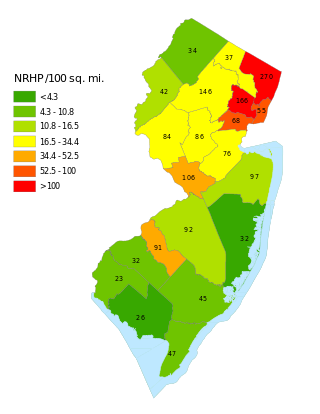
This is a list of properties and districts listed on the National Register of Historic Places in New Jersey. There are more than 1,700 listed sites in New Jersey. Of these, 58 are further designated as National Historic Landmarks. All 21 counties in New Jersey have listings on the National Register.
This National Park Service list is complete through NPS recent listings posted December 20, 2024.

Delaware is an unincorporated community and census-designated place (CDP) located along the Delaware River within Knowlton Township in Warren County, New Jersey. It was created as part of the 2010 United States Census. As of the 2010 Census, the CDP's population was 150. The area is served as United States Postal Service ZIP Code 07833.

Johnsonburg is an unincorporated community and census-designated place (CDP) located within Frelinghuysen Township in Warren County, in the U.S. state of New Jersey, that was created as part of the 2010 United States Census. As of the 2020 Census, the CDP's population was 381, up from 101 in the 2010 Census.

Asbury is an unincorporated community and census-designated place (CDP) located within Franklin Township in Warren County, in the U.S. state of New Jersey, that was created as part of the 2010 United States Census. As of the 2010 Census, the CDP's population was 273.

Finesville is an unincorporated community and census-designated place (CDP) located within Pohatcong Township in Warren County, in the U.S. state of New Jersey. The CDP was defined as part of the 2010 United States Census. As of the 2010 Census, the CDP's population was 175.
The New Hampton Historic District is a 76-acre (31 ha) historic district in the village of New Hampton in Lebanon Township in Hunterdon County, New Jersey, United States. The district was added to the National Register of Historic Places on April 6, 1998, for its significance in architecture, commerce, education, transportation, and community development from c. 1780 to 1929. It includes 42 contributing buildings, six contributing sites, and four contributing structures located along Musconetcong River Road.

Headquarters is an unincorporated community located within the Amwell Valley of Delaware Township in Hunterdon County, New Jersey. The settlement is centered around the intersection of Zentek Road and County Route 604. It is about 3 miles (4.8 km) from Ringoes to the east and 1 mile (1.6 km) from Sergeantsville to the west. The Headquarters Historic District was listed on the state and national registers of historic places in 2011 and had its boundary increased in 2016.

Millbrook, also known as Millbrook Village, is an unincorporated community located along Old Mine Road within Hardwick Township, formerly Pahaquarry Township, in Warren County, in the U.S. state of New Jersey. It is named after the Mill Brook, now known as Van Campens Mill Brook, a tributary of the Delaware River. The area is now part of the Delaware Water Gap National Recreation Area.

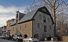
The Belvidere Historic District is a 132-acre (53 ha) historic district encompassing the town of Belvidere, the county seat of Warren County, New Jersey, United States. It was added to the National Register of Historic Places on October 3, 1980 for its significance in architecture, commerce, community planning, industry, politics and government during the 19th century. The district is bounded by Market and Race streets; Greenwich and Mansfield avenues; and the Pequest River. It contains 228 contributing buildings, including the Warren County Courthouse.

The Asbury Historic District is a 288-acre (117 ha) historic district encompassing the community of Asbury in Franklin Township of Warren County, New Jersey. It is bounded by County Route 632, County Route 643, Maple Avenue, Kitchen Road, and School Street and extends along the Musconetcong River into Bethlehem Township of Hunterdon County. It was listed on the National Register of Historic Places on March 19, 1993 for its significance in architecture, industry, religion, community development, politics/government, and commerce. The district includes 141 contributing buildings, a contributing structure, two contributing sites, and four contributing objects.

The New Hampton Pony Pratt Truss Bridge is a historic pony Pratt truss bridge on Shoddy Mill Road in New Hampton of Lebanon Township, Hunterdon County, New Jersey. It crosses the Musconetcong River between Lebanon Township, Hunterdon County and Washington Township, Warren County. It was designed by Francis C. Lowthorp and built in 1868 by William Cowin of Lambertville, New Jersey. The bridge was added to the National Register of Historic Places on July 26, 1977 for its significance in engineering, industry and transportation. It is one of the few early examples of iron Pratt truss bridges remaining in the United States. It was later documented by the Historic American Engineering Record in 1991. It was added as a contributing property to the New Hampton Historic District on April 6, 1998.

The Imlaydale Historic District is a 32-acre (13 ha) historic district primarily in Washington Township of Warren County, New Jersey. It was added to the National Register of Historic Places on March 27, 1991 for its significance in architecture, community development, industry, politics/government, and transportation. The listing includes 12 contributing buildings, four contributing structures, and two contributing sites.

The Beattystown Historic District is a 35-acre (14 ha) historic district in the village of Beattystown in Mansfield Township of Warren County, New Jersey, United States. The district was added to the National Register of Historic Places on September 28, 1990 for its significance in architecture, commerce, industry, and settlement pattern from 1762 to 1929. It includes 32 contributing buildings.

Pleasant Valley is an unincorporated community located in Washington Township, Warren County, New Jersey, west of Washington, along the Pohatcong Creek. The hamlet was built around a mill on the creek during the mid-18th century. The Pleasant Valley Historic District, encompassing the village, is listed on the state and national registers of historic places.

The Hixson–Skinner Mill Complex, also known as Cole's Grist Mill Complex, encompasses a historic grist mill and two houses located where Still Valley Road crosses the Pohatcong Creek, about one half mile east of Springtown, in Pohatcong Township in Warren County, New Jersey, United States. It was added to the National Register of Historic Places on December 2, 1982, for its significance in commerce and industry. The 2.5-acre (1.0 ha) district includes four contributing buildings and two contributing structures.
Springtown is an unincorporated community located at the intersection of Springtown Road and the Pohatcong Creek in Pohatcong Township, Warren County, New Jersey. It was named after the many small springs in the valley.

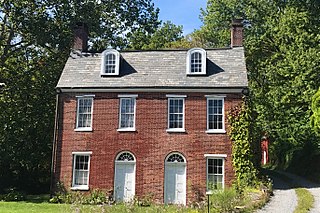
The Seigle Homestead is a historic house built around 1793 and located along Riegelsville-Warren Glen Road in the Finesville section of Pohatcong Township, the only surviving two-story log house in Warren County, New Jersey. It was added to the National Register of Historic Places on November 7, 1977, for its significance in architecture and social history. The log house was listed as a contributing property of the Finesville–Seigletown Historic District on November 10, 2010.

Millville is an unincorporated community located along River Road and Shimers Brook in Montague Township of Sussex County, New Jersey. The Montague Grange and other parts of the community are in the Delaware Water Gap National Recreation Area.