Related Research Articles

Tunbridge is a town in Orange County, Vermont, United States. As of the 2020 United States Census the town population was 1,337. The town consists of three village centers, all situated on Vermont Route 110 in the valley of the first branch of the White River. The three settlements are named North Tunbridge, Tunbridge Village ("Market") and South Tunbridge ("Jigger").
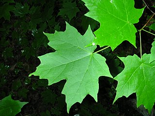
Acer saccharum, the sugar maple, is a species of flowering plant in the soapberry and lychee family Sapindaceae. It is native to the hardwood forests of eastern Canada and the eastern United States. Sugar maple is best known for being the primary source of maple syrup and for its brightly colored fall foliage. It may also be called "rock maple," "sugar tree," "sweet maple," or, particularly in reference to the wood, "hard maple," "birds-eye maple," or "curly maple," the last two being specially figured lumber.

Mount Mansfield is the highest mountain in Vermont, reaching an elevation of 4,393 feet (1,339 m) above sea level. Located in the northwest of the state, it is also the highest peak in the Green Mountains. Its summit is located within the town of Underhill in Chittenden County; the ridgeline, including some secondary peaks, extends into the town of Stowe in Lamoille County, and the mountain's flanks also reach into the town of Cambridge.

Rigaud is a city in southwestern Quebec, Canada, in the Vaudreuil-Soulanges Regional County Municipality in Vallée-du-Haut-Saint-Laurent region. It is located at the junction of the Ottawa River and the Rigaud River, about 70 kilometres (43 mi) west of downtown Montreal and 130 kilometres (81 mi) east of Ottawa. The population as of the Canada 2021 Census was 7,854.

Potton is a township municipality of about 2,500 people in the Memphrémagog Regional County Municipality. It is located on the western shore of Lake Memphremagog in the Estrie region of Quebec, and is one of the municipalities in Brome County. Potton is located about 125 kilometres (78 mi) southeast of Montreal, 30 kilometres (19 mi) to the southwest of the city of Magog, and next to the United States border, north of North Troy, Vermont.

Loam is soil composed mostly of sand, silt, and a smaller amount of clay. By weight, its mineral composition is about 40–40–20% concentration of sand–silt–clay, respectively. These proportions can vary to a degree, however, and result in different types of loam soils: sandy loam, silty loam, clay loam, sandy clay loam, silty clay loam, and loam.

The Town of Brome Lake is a town in southern Quebec, Canada. The population as of the Canada 2011 Census was 5,609. Tourism is a major industry in the village of Knowlton because of skiing in the winter, lake activities in summer, and autumn leaf colour.
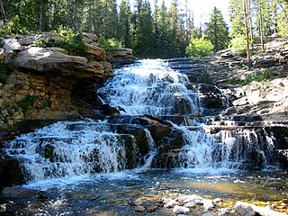
The Provo River is located in Utah County and Wasatch County, Utah, in the United States. It rises in the Uinta Mountains at Wall Lake and flows about 71 miles (114 km) southwest to Utah Lake at the city of Provo, Utah.
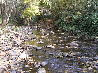
Santa Rosa Creek is a 22-mile-long (35 km) stream in Sonoma County, California, which rises on Hood Mountain and discharges to the Laguna de Santa Rosa by way of the Santa Rosa Flood Control Channel. This article covers both the creek and the channel.

San Joaquin is an officially designated state insignia, the state soil of the U.S. state of California.

The New England-Acadian forests are a temperate broadleaf and mixed forest ecoregion in North America that includes a variety of habitats on the hills, mountains and plateaus of New England and New York State in the Northeastern United States, and Quebec and the Maritime Provinces of Eastern Canada.

Santa Maria Valley is an American Viticultural Area (AVA) which straddles the boundary of Santa Barbara and San Luis Obispo counties in California's multi-county Central Coast AVA. It was established on August 5, 1981, by the Bureau of Alcohol, Tobacco, Firearms and Explosives (ATF) as California's second oldest AVA. A portion of the AVA crosses the Cuyama River into the southernmost corner of San Luis Obispo County. The east-west orientation of the 152.3 square miles with a wide, open valley and rolling hills means cool winds and fog flow in freely from the Pacific Ocean, settling most noticeably in lower-lying areas. The result is a mild Mediterranean climate that lengthens the growing season and contributes to the eventual sugar/acid balance in the grapes from Santa Maria Valley's 7,500 acres (3,000 ha) cultivated vineyards. On January 28, 2011, the AVA was granted a 29.4 square miles expansion to its southern boundary.
Berkshire soil series is the name given to a well-drained loam or sandy loam soil which has developed on glacial till in parts of southern Quebec, eastern New York State and New England south to Massachusetts. It belongs to the podzol soil group and is one of the most important soils in its area of occurrence, supporting extensive forests and a fair number of farms. Many Berkshire soils lack the eluvial (E) horizon characteristic of podzols because they have a history of being cleared for cultivation.
Blandford, officially known as Blandford Forum is a small historic market town in the English county of Dorset, United Kingdom. Blandford may also refer to:

Yamaska National Park is a provincial park centered on the man-made Choinière Reservoir. It is located in the municipalities of Roxton Pond and Saint-Joachim-de-Shefford in La Haute-Yamaska Regional County Municipality, just northeast of Granby, Quebec.

Adiantum viridimontanum, commonly known as Green Mountain maidenhair fern, is a fern found only in outcrops of serpentine rock in New England and Eastern Canada. The leaf blade is cut into finger-like segments, themselves once-divided, which are borne on the outer side of a curved, dark, glossy rachis. These finger-like segments are not individual leaves, but parts of a single compound leaf. The "fingers" may be drooping or erect, depending on whether the individual fern grows in shade or sunlight. Spores are borne under false indusia at the edge of the subdivisions of the leaf, a characteristic unique to the genus Adiantum.
Dubakella soil series is the name given to a reddish-brown stony loam soil which has developed on ultramafic rock containing magnesium minerals such as serpentine or asbestos. This soil occurs from southwestern Oregon south to the Coast Ranges of California near Healdsburg, and it also is found in the Sierra Nevada mountains and foothills.
The geology of Maine is part of the broader geology of New England and eastern North America.
Squaw Valley-Miramonte is an American Viticultural Area (AVA) and a unique grape-growing region in Fresno County, California surrounding the towns of Yokuts Valley and Miramonte approximately 40 miles (64 km) east of the city of Fresno. The AVA was established on August 7, 2015 by the U.S. Department of Treasury’s Alcohol and Tobacco Tax and Trade Bureau (TTB). It is largely a rural region located entirely within the foothills of the Sierra Nevada mountains and does not overlap any established AVAs. To the northwest, west, and south is the San Joaquin Valley while the Sequoia National Forest is adjacent to its northern and eastern boundaries. The scenic highway U.S. 180 bisects the region eastward from the Valley to the Big Trees in Kings Canyon and Sequoia National Parks. The AVA stretches over 44,690 acres (70 sq mi) with five commercially-producing vineyards cultivating about 7.5 acres (3.04 ha) and three bonded wineries. The USDA plant hardiness zone for the AVA is 9b.

The Northeastern Highlands Ecoregion is a Level III ecoregion designated by the United States Environmental Protection Agency (EPA) in the U.S. states of Vermont, New Hampshire, Massachusetts, Maine, Connecticut, New York, New Jersey, and Pennsylvania. The ecoregion extends from the northern tip of Maine and runs south along the Appalachian Mountain Range into eastern Pennsylvania. Discontiguous sections are located among New York's Adirondack Mountains, Catskill Range, and Tug Hill. The largest portion of the Northeastern Highlands ecoregion includes several sub mountain ranges, including the Berkshires, Green Mountains, Taconic, and White Mountains.