
The tufted puffin, also known as crested puffin, is a relatively abundant medium-sized pelagic seabird in the auk family (Alcidae) found throughout the North Pacific Ocean. It is one of three species of puffin that make up the genus Fratercula and is easily recognizable by its thick red bill and yellow tufts.

Puffins are any of three species of small alcids (auks) in the bird genus Fratercula. These are pelagic seabirds that feed primarily by diving in the water. They breed in large colonies on coastal cliffs or offshore islands, nesting in crevices among rocks or in burrows in the soil. Two species, the tufted puffin and horned puffin, are found in the North Pacific Ocean, while the Atlantic puffin is found in the North Atlantic Ocean.
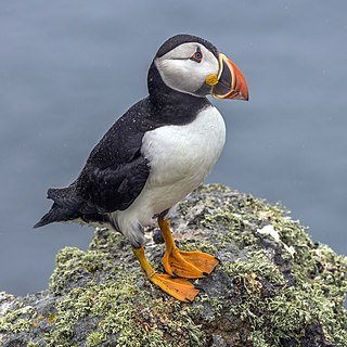
The Atlantic puffin, also known as the common puffin, is a species of seabird in the auk family. It is the only puffin native to the Atlantic Ocean; two related species, the tufted puffin and the horned puffin, are found in the northeastern Pacific. The Atlantic puffin breeds in Québec, Iceland, Norway, Greenland, Newfoundland and Labrador, Nova Scotia and the Faroe Islands, and as far south as Maine in the west and France in the east. The Atlantic Puffin is most commonly found on the Westman Islands, Iceland. Although it has a large population and a wide range, the species has declined rapidly, at least in parts of its range, resulting in it being rated as vulnerable by the IUCN. On land, it has the typical upright stance of an auk. At sea, it swims on the surface and feeds mainly on small fish, which it catches by diving under water, using its wings for propulsion.
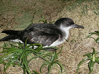
The Manx shearwater is a medium-sized shearwater in the seabird family Procellariidae. The scientific name of this species records a name shift: Manx shearwaters were called Manks puffins in the 17th century. Puffin is an Anglo-Norman word for the cured carcasses of nestling shearwaters. The Atlantic puffin acquired the name much later, possibly because of its similar nesting habits.

The yelkouan shearwater, Levantine shearwater or Mediterranean shearwater is a medium-sized shearwater in the seabird family Procellariidae.

The rhinoceros auklet is a seabird and a close relative of the puffins. It is the only extant species of the genus Cerorhinca. Given its close relationship with the puffins, the common name rhinoceros puffin has been proposed for the species.
The Hula Valley is an agricultural region in northern Israel with abundant fresh water, which used to be Lake Hula, prior to its draining. It is a major stopover for birds migrating along the Syrian-African Rift Valley between Africa, Europe, and Asia.

The Varangerfjord is the easternmost fjord in Norway, north of Finland. The fjord is located in Troms og Finnmark county between the Varanger Peninsula and the mainland of Norway. The fjord flows through the municipalities of Vardø, Vadsø, Nesseby, and Sør-Varanger. The fjord is approximately 100 kilometres (62 mi) long, emptying into the Barents Sea. In a strict sense, it is a false fjord, since it does not have the hallmarks of a fjord carved by glaciers.
Kubbar is a sandy island of Kuwait in the Persian Gulf, covered with shrub. It is located roughly 30 kilometers off the southern coast of Kuwait and 29 kilometres off the coast of Failaka. The island is nearly circular, with a diameter of 370 to 380 meters, corresponding to an area of about 11 ha.

The island of Lunga is the largest of the Treshnish Isles in Argyll and Bute, Scotland. The Isles are part of the Loch Na Keal National Scenic Area.
The Atlantic petrel is a gadfly petrel endemic to the South Atlantic Ocean. It breeds in enormous colonies on Tristan da Cunha and Gough Island, and ranges at sea from Brazil to Namibia, with most records at sea being to the west of the breeding islands, and along the subtropical convergence.

The Curzon Islands are a small group of rocky islands lying close off Cape Découverte, Adélie Coast. They were probably sighted in January 1840 by a French expedition under Captain Jules Dumont d'Urville, though not identified as islands on d'Urville's maps. The islands were roughly charted in 1912 by Captain J.K. Davis of the Australasian Antarctic Expedition ship Aurora and named by Mawson for Lord Curzon, the President of the Royal Geographical Society, 1911–14. The islands were mapped in detail by the French Antarctic Expedition, 1950–52.

Dodman Island is an island 6.5 km (4.0 mi) long, lying 7.4 km (4.6 mi) south-east of Rabot Island and 18.5 km (11.5 mi) west of Ferin Head, off the west coast of Graham Land, Antarctica. The island was charted and named by the British Graham Land Expedition, 1934–37, under John Rymill.

Macklin Island is a small island in the eastern part of the Robinson Group, about 3 kilometres (1.5 nmi) north of Kirton Island, and 6 kilometres (3 nmi) northwest of Cape Daly, Mac. Robertson Land, Antarctica. It was mapped by Norwegian cartographers from air photos taken by the Lars Christensen Expedition, 1936–37, and was named by the Antarctic Names Committee of Australia for E.L. Macklin, a radio officer at Mawson Station in 1955 and 1959.

Point Wordie is a headland on the western coast of Elephant Island, in the South Shetland Islands of Antarctica. The site is named after James Wordie, a Scottish geologist who participated in Ernest Shackleton’s Imperial Trans-Antarctic Expedition, 1914–1917.

Dok-do is a small, rocky island in the north-eastern Yellow Sea lying about 15 km off the western coast of North Korea. It rises to a height of 85 m and has an area of 18 ha. Based on surveys conducted in 1997 and 1998, the site has been identified by BirdLife International as an Important Bird Area (IBA) because it supports small numbers of breeding endangered black-faced spoonbills and vulnerable Chinese egrets. The island has been classified as one of the Natural monuments of South Korea. The main threat to the birds is from human disturbance.
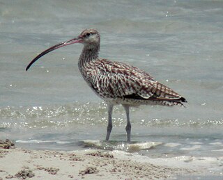
The Sogam-do, Daegam-do, Zung-do, Ae-do and Hyengzedo Islands Important Bird Area comprises a group of small islands, with a collective area of 18 ha, in the north-eastern Yellow Sea, lying close to the western coast of North Korea. The site has been identified by BirdLife International as an Important Bird Area (IBA) because it supports breeding endangered black-faced spoonbills as well as vulnerable Chinese egrets and up to 850 Far Eastern curlews as passage migrants. The site has been designated one of North Korea's Natural Monuments.

Nord-Fugløya or Fugløya is an uninhabited island in Karlsøy Municipality in Troms og Finnmark, Norway. The highest mountain is the 750-metre (2,460 ft) tall Fugløykallen. Fugløykalven Lighthouse is located north of the island.

The Eastern Litwin Bay Important Bird Area lies between Stigant Point and Davey Point on the northern coast of King George Island in the South Shetland Islands of Antarctica. Here a 500 ha Important Bird Area (IBA) has been designated by BirdLife International because it supports breeding seabirds, notably large numbers of chinstrap penguins with counts of 8,500 to 12,500 breeding pairs made in the area. The site comprises islets in Litwin Bay, the adjacent coast of King George Island and the intervening sea.
Sørfugløya or Sør-Fugløy is a small (97 ha) uninhabited island and nature reserve in Karlsøy Municipality, Troms og Finnmark county, in Arctic northern Norway. It lies just north-west of the larger inhabited island of Rebbenesøya. It is a steep island with grassy slopes surrounded by boulder scree. It, with its adjacent marine waters, has been designated a 760 ha Important Bird Area (IBA) by BirdLife International because it supports large breeding colonies of Atlantic puffins and razorbills. European storm petrels also breed on the island.
