Bull Shoals Lake is an artificial lake or reservoir in the Ozark Mountains of northern Arkansas and southern Missouri, United States. It has hundreds of miles of lake arms and coves, and common activities include boating, water sports, swimming, and fishing. Nineteen developed parks around the shoreline provide campgrounds, boat launches, swim areas, and marinas.

Beaver Lake is a man-made reservoir in the Ozark Mountains of Northwest Arkansas and is formed by a dam across the White River. Beaver Lake has some 487 miles (784 km) of shoreline. With towering limestone bluffs, natural caves, and a wide variety of trees and flowering shrubs, it is a popular tourist destination. Beaver Lake is the source of drinking water in Northwest Arkansas, which is managed, treated and sold by Beaver Water District, serving more than 450,000 customers. One out of 7 people in Arkansas get their drinking water from Beaver Lake.

Tenkiller Ferry Lake, or more simply, Lake Tenkiller, is a reservoir in eastern Oklahoma formed by the damming of the Illinois River. The earth-fill dam was constructed between 1947 and 1952 by the United States Army Corps of Engineers for purposes of flood control, hydroelectric power generation, water supply and recreation. It went into full operation in 1953. The lake and dam were named for the Tenkiller family, prominent Cherokees who owned the land and ferry that were bought for the project. This is the 6th largest lake in Oklahoma, based on water capacity.

Fort Peck Lake, or Lake Fort Peck, is a major reservoir in Montana, formed by the Fort Peck Dam on the Missouri River. The lake lies in the eastern prairie region of Montana approximately 140 miles (230 km) east of Great Falls and 120 miles (190 km) north of Billings, reaching into portions of six counties.

Lake Oahe is a large reservoir behind Oahe Dam on the Missouri River; it begins in central South Dakota and continues north into North Dakota in the United States. The lake has an area of 370,000 acres (1,500 km2) and a maximum depth of 205 ft (62 m). By volume, it is the fourth-largest reservoir in the US. Lake Oahe has a length of approximately 231 mi (372 km) and has a shoreline of 2,250 mi (3,620 km). 51 recreation areas are located along Lake Oahe, and 1.5 million people visit the reservoir every year. The lake is named for the 1874 Oahe Indian Mission.
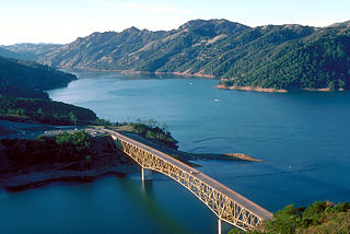
Lake Sonoma is a reservoir west of Cloverdale in northern Sonoma County, California, created by the construction of Warm Springs Dam. The lake provides water for countywide growth and development, and for recreation.

Table Rock Lake is an artificial lake or reservoir in the Ozarks of southwestern Missouri and northwestern Arkansas in the United States. Designed, built and operated by the U.S. Army Corps of Engineers, the lake is impounded by Table Rock Dam, which was constructed from 1954 to 1958 on the White River.

Curecanti National Recreation Area is a National Park Service unit located on the Gunnison River in western Colorado. Established in 1965, Curecanti National Recreation Area is responsible for developing and managing recreational facilities on three reservoirs, Blue Mesa Reservoir, Morrow Point Reservoir and Crystal Reservoir, constructed on the upper Gunnison River in the 1960s by the U.S. Bureau of Reclamation to better utilize the vital waters of the Colorado River and its major tributaries. A popular destination for boating and fishing, Curecanti offers visitors two marinas, traditional and group campgrounds, hiking trails, boat launches, and boat-in campsites. The state's premiere lake trout and Kokanee salmon fisheries, Curecanti is a popular destination for boating and fishing, and is also a popular area for ice-fishing in the winter months.

Lewis and Clark Lake is a 31,400 acre (130 km²) reservoir located on the border of the U.S. states of Nebraska and South Dakota on the Missouri River. The lake is approximately 25 miles (40 km) in length with over 90 miles (140 km) of shoreline and a maximum water depth of 45 feet (14 m). The lake is impounded by Gavins Point Dam and is managed by the U.S. Army Corps of Engineers, Omaha District.
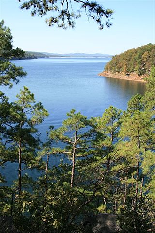
Lake Ouachita is a reservoir created by the damming of the Ouachita River by Blakely Mountain Dam.
Gillham Lake is a small reservoir located along the Cossatot River, mostly in Howard County, but also extending westward into Polk County, Arkansas. The lake is 6 miles (9.7 km) from Gillham, Arkansas.

Lake Dardanelle is a major reservoir on the Arkansas River in Arkansas, USA. and is an integral part of the McClellan-Kerr Arkansas River Navigation System (MKARNS), which allows barge transportation from the Mississippi River to the Tulsa Port of Catoosa in northeastern Oklahoma. MKARNS went into service along its full length in 1971.

Wilson Lake is a reservoir in the U.S. state of Kansas, on the border of Russell County and Lincoln County. Built and managed by the U.S. Army Corps of Engineers for flood control, it is also used for wildlife management and recreation. Several parks are located along its shoreline, including Wilson State Park.

Perry Lake is a US Army Corps of Engineers operated reservoir in northeast Kansas. Its primary purposes are flood control, water reserve for nearby areas and regional recreation. The lake is approximately 11,150 acres (45 km2) in size, with over 160 miles (260 km) of shoreline. Perry Lake's full multi-purpose pool elevation is 891.5 feet (271.7 m) above sea level. Perry Lake is located about 40 miles (64 km) west of Kansas City, just northwest of Lawrence, Kansas. Its close proximity to Kansas City, Lawrence, and the state capitol, Topeka, make it a very popular destination, with the nickname "Paradise on the Plains".

El Dorado Lake is a reservoir on the Walnut River 0.5 miles (0.80 km) northeast of El Dorado in the Flint Hills region of Kansas. Built and managed by the U.S. Army Corps of Engineers, it is used for flood control, recreation, and water supply. El Dorado State Park is located on its shore.

John Redmond Reservoir is a reservoir on the Neosho River in eastern Kansas. Built and managed by the U.S. Army Corps of Engineers, it is used for flood control, recreation, water supply, and wildlife management. It borders the Flint Hills National Wildlife Refuge to the northwest.

Kanopolis Lake is a reservoir in Ellsworth County in the Smoky Hills of central Kansas, about 31 miles southwest of Salina and a few miles southeast of the town of Kanopolis. The lake is formed by Kanopolis Dam. Completed in 1948 as a flood control and water conservation project of the United States Army Corps of Engineers, the dam impounds the Smoky Hill River.
John Martin Reservoir is a reservoir on the Arkansas River in Bent County in southeastern Colorado. Built and managed by the U.S. Army Corps of Engineers, it is used for flood control, irrigation, and recreation. John Martin Reservoir State Park lies on its shore.

West Point Lake is a man-made reservoir located mostly in west-central Georgia on the Chattahoochee River and maintained by the U.S. Army Corps of Engineers (USACE). The Chattahoochee river flows in from the north, before flowing through the West Point Dam, which impounds the lake, and continuing to Columbus, Georgia. Of the four major USACE lakes in the ACF River Basin, West Point Lake is the smallest by area containing 25,864 acres (10,467 ha) of water, and has the second shortest shoreline at 604 mi (972 km). The purposes of the reservoir are to provide flood control, hydroelectric power, and water storage to aid the navigation of the lower Chattahoochee.