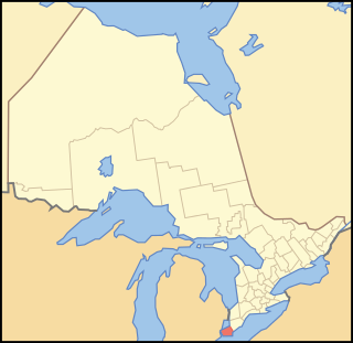
Ontario is one of the thirteen provinces and territories of Canada. Located in Central Canada, it is Canada's most populous province, with 38.3 percent of the country's population, and is the second-largest province in total area. Ontario is the fourth-largest jurisdiction in total area when the territories of the Northwest Territories and Nunavut are included. It is home to the nation's capital city, Ottawa, and the nation's most populous city, Toronto, which is also Ontario's provincial capital.

Windsor is a city in southwestern Ontario, Canada, on the south bank of the Detroit River directly across from Detroit, Michigan, United States. Located in Essex County, it is the southernmost city in Canada and marks the southwestern end of the Quebec City–Windsor Corridor. The city's population was 217,188 at the 2016 census, making it the third-most populated city in Southwestern Ontario, after London and Kitchener. The Detroit–Windsor urban area is North America's most populous trans-border conurbation, and the Ambassador Bridge border crossing is the busiest commercial crossing on the Canada–United States border.

Essex County is a primarily rural county in Southwestern Ontario, Canada comprising seven municipalities: Amherstburg, Kingsville, Lakeshore, LaSalle, Leamington, Tecumseh and the administrative seat, Essex. Essex County has a population of 181,530 as of the Canada 2016 Census.

Leamington is a municipality in Essex County, Ontario, Canada. With a population of 27,595 in the Canada 2016 Census, it is the second-largest municipality in the Windsor-Essex County area. It includes Point Pelee National Park, the southernmost point of mainland Canada.

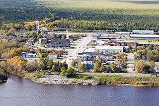
Moosonee is a town in northern Ontario, Canada, on the Moose River approximately 19 kilometres (12 mi) south of James Bay. It is considered to be "the Gateway to the Arctic" and has Ontario's only saltwater port. Nearby on Moose Factory Island is the community of Moose Factory to which it is connected by water taxi in the summer and ice road in the winter.

Lakeshore is a town on Lake St. Clair, in Essex County, Ontario, Canada. The town was incorporated in 1999 by amalgamating the Town of Belle River with the townships of Maidstone, Rochester, Tilbury North, and Tilbury West. It is part of the Windsor census metropolitan area.

Wainfleet is a rural township in southern Niagara Region, Ontario, Canada.

Wolfe Island is an island at the entrance to the Saint Lawrence River in Lake Ontario near Kingston, Ontario. Wolfe Island is part of Frontenac County, Ontario and the Township of Frontenac Islands. It is the largest of the Thousand Islands. The largest community on the island is Marysville. The island was part of the traditional hunting lands of the Tyendinaga Mohawk people and the original name of the island is Ganounkouesnot. It was called Grand Island. In a proclamation by the Lieutenant Governor of Upper Canada John Graves Simcoe on 16 July 1792, the island was renamed from Grand island to Wolfe island, after British General James Wolfe.

Crawford Lake Conservation Area is a conservation area owned and operated by Conservation Halton near the community of Campbellville in Milton, Halton, Ontario, Canada. It is categorized as a regional environmentally sensitive area, an Ontario Area of Natural and Scientific Interest, and part of the Niagara Escarpment world biosphere reserve. The conservation area contains Crawford Lake, a reconstructed Iroquoian village, and several hiking trails.

The Pikangikum First Nation is an Ojibwe First Nation located on the 1,808-hectare (4,470-acre) Pikangikum 14 Reserve, in Unorganized Kenora District in Northwestern Ontario, Canada. The main centre is the community of Pikangikum, on Pikangikum Lake on the Berens River, part of the Hudson Bay drainage system; it is approximately 100 kilometres (60 mi) north of the town of Red Lake.

Batchawana Bay is a small bay in Algoma District in Northeastern Ontario, Canada. It is on the eastern shore of Lake Superior, approximately 50 kilometres (31 mi) north of Sault Ste. Marie. Batchawana Bay was termed Badjiwanung by the Ojibwe, referring to water that bubbles up. This occurs between Batchawana Island and Sand Point, where the lake narrows and a strong current and undertow results. The Ojibwe believed this was caused by an underwater spirit about to surface.

Brown's Corners is an unincorporated community in Markham, Regional Municipality of York in the Greater Toronto Area of Ontario, Canada and located near the corner of Woodbine Avenue and Highway 7. The community, founded in 1842, was named for local settler Alexander Brown, Sr. (1771–1851) who acquired 100 acres (40 ha) in 1838. Beaver Creek flows through it.

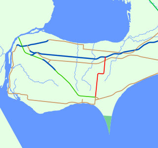
King's Highway 77, commonly referred to as Highway 77, is a provincially maintained highway in the Canadian province of Ontario. One of three highways within Essex County, Highway 77 serves to interconnect Highway 3 near Leamington with Highway 401 near Tilbury. Prior to 1998, the highway extended south into Leamington, ending at the former routing of Highway 3 and Highway 18. This section was turned over to Essex County and renamed Erie Street. The speed limit on Highway 77 is 80 km/h (50 mph) in most places, dropping to 50 km/h in built-up areas. It is patrolled by the Ontario Provincial Police.

Brown's Corners is the name of a community in Scarborough in Toronto, Ontario, Canada at the corner of Finch Avenue East and Markham Road.

Silverwood Heights is a mostly residential neighbourhood located in north-central Saskatoon, Saskatchewan, Canada. It is a suburban subdivision, composed mostly of single detached dwellings and some multiple-unit apartment and semi-detached dwellings. As of 2009, the area is home to 10,786 residents. The neighbourhood is considered a middle to high-income area, with an average family income of $93,772, an average dwelling value of $324,547 and a home ownership rate of 78.8%. According to MLS data, the average sale price of a home as of 2013 was $399,760. By land area and population, Silverwood Heights is the largest subdivision in Saskatoon.

Wolfe Island Wind Farm is a large wind farm project located on Wolfe Island, Ontario. The wind farm became operational on June 29, 2009. It is owned and operated by Canadian Hydro Developers, Inc., through its subsidiary Canadian Renewable Energy Corporation (CREC). The power will be purchased by Hydro One for distribution to consumers.

As of 2019, renewable energy technologies provide about 17.3% of Canada's total primary energy supply and about 67% of its electricity production.
Mount Carmel – Blytheswood Public School is an elementary school in the north end of Leamington, Ontario, Canada. It is part of the Greater Essex County District School Board and serves students from JK to Grade 8 from the communities of Blytheswood and Mount Carmel and surrounding areas. The amalgamated Mount Carmel-Blytheswood Public School first operated in the academic year 2002–2003 with the opening of an addition, completed in the fall of 2002, which more than doubled the size of the school.

Island Lake is a settlement in the Unorganized North Part of Sudbury District in northeastern Ontario, Canada. It is located about 20 kilometres (12 mi) southwest of Chapleau, and 15 kilometres (9 mi) southwest of the junction of Ontario Highway 101 and Ontario Highway 129 near the settlement of Devon on the Canadian Pacific Railway.
The Leamington Post was a weekly newspaper published in Leamington, Ontario, from 1874 to 2012.


