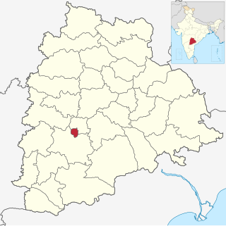
Nalgonda district is a district in the Telangana state of India. Nalgonda district has the highest number of mandals in the state with 31 mandals. The district shares boundaries with Suryapet, Rangareddy, Yadadri and Nagarkurnool districts and with the state boundary of Andhra Pradesh. In terms of area, Nalgonda is the largest district with an area of 7222.78 km2 in the state.

Ranga Reddy district is a district in the Indian state of Telangana. The district headquarters is located at Kongara Kalan Village, Ibrahimpatnam Mandal,. The district was named after the former deputy chief minister of the United Andhra Pradesh, K. V. Ranga Reddy. The district shares boundaries with Nalgonda, Yadadri Bhuvanagiri, Hyderabad, Medchal–Malkajgiri, Nagarkurnool, Mahabubnagar, Sangareddy and Vikarabad districts.

Hyderabad district is a district in the state of Telangana in India that contains a part of the metropolitan area of Hyderabad. It is headed by a district collector who is drawn from the IAS cadre and is appointed by the state government. It is the smallest of all the districts in the state, but has the highest population density. Old MCH area, which is central region of Hyderabad city comes under this district. The district shares boundaries with Rangareddy and Medhchal districts.
Chevella is a town, mandal and suburb of Hyderabad in Ranga Reddy district of the Indian state of Telangana. It is the headquarters of surrounding villages with many government establishments like Judicial court, Revenue Division Office, Acp office under Cyberabad Metropolitan Police. It is also an educational hub with many schools, junior colleges, engineering colleges, business schools etc. There are many hospitals located along with a medical college, the Dr. Patnam Reddy Institute of Medical Sciences. It has become a part of Hyderabad Metropolitan Development Authority.

Manchala is a village & Mandal in Ranga Reddy district of Telangana state, India. It is located nearly 45km towards South-East from MGBS bust station .it comes under Ibrahimpatnam revenue division.
Bandalemoor is a village and panchayat in Ranga Reddy district, Telangana, India. It falls under Manchal mandal.
Cheeded is a village and panchayat in Ranga Reddy district, Telangana, India. It falls under Manchal mandal.
Dadpally is a village and panchayat in Ranga Reddy district, Telangana, India. It falls under Manchal mandal.
Japal is a village and panchayat in Ranga Reddy district, Telangana, India. It falls under Manchal mandal.
Lingampally is a village and panchayat in Ranga Reddy district, Telangana, India. It falls under Manchal mandal.
Loyapally is a village and panchayat in Ranga Reddy district, Telangana, India. It falls under Manchal mandal.
Nomula is a village and panchayat in Ranga Reddy district, Telangana, India. It falls under Manchal mandal.
Rangapur is a village in Ranga Reddy district of Telangana, India. It falls under Manchal mandal. It is also famous as "Chukkapuri Gutta" by having one of the Indian observatories in it. It is located 50 km from Hyderabad.
Tippaiguda is a village and panchayat in Ranga Reddy district, Telangana, India. It falls under Manchal mandal.

Sangareddy district, is a district located in the western region of the Indian state of Telangana. This district contains a part of the Hyderabad Metropolitan Region.Sangareddy is the district headquarters of the district. It was named after the ruler Sanga, the son of queen Shankaramba, who was the ruler of Medak during the period of Nizams. The district shares boundaries with Medak, Medchal, Vikarabad, Kamareddy and Rangareddy districts and with the state boundary of Karnataka.

Yadadri Bhuvanagiri District, is a district in the Indian state of Telangana. The administrative headquarters is located at Bhuvanagiri Town. The district shares boundaries with Suryapet, Nalgonda, Jangaon, Siddipet, Medchal-Malkajgiri and Rangareddy districts. It was carved out of Nalgonda district on 11 October 2016 during a large reorganization of the districts of Telangana.

Bhadradri Kothagudem is a district in the east of the Indian state of Telangana. Kothagudem is the district headquarters. It is the largest district in Telangana, with an area of 7483 km2. It borders the districts Khammam, Mahabubabad, Mulugu, Eluru and East Godavari, and shares a boundary with the bordering states Chhattisgarh and Andhra Pradesh. The district comprises 24 mandals and 2 revenue divisions, Kothagudem and Bhadrachalam.

Medchal−Malkajgiri district is a district in the Indian state of Telangana. Shamirpet is the headquarter of the district. It is the second most populous district in the state with a population of 2.5 million and also 91.40% urbanized district in the state of Telangana, standing next only to Hyderabad district which has a population of 4 million. The district shares boundaries with Hyderabad, Medak, Sangareddy, Y. Bhuvanagiri, Siddipet and Rangareddy districts.The most part of the district consist of Hyderabad City (GHMC)
Moinabad mandal is one of the 27 mandals in Ranga Reddy district of the Indian state of Telangana. It is under the administration of Chevella revenue division and has its headquarters at Moinabad.
Arutla is a village in Manchal Mandal in Rangareddy District of Telangana State, India.


