
The Merrick, or simply Merrick, is a mountain in the Range of the Awful Hand, a sub-range of the Galloway Hills range, part of the Southern Uplands of Scotland. The summit elevation is 843 metres, making it the highest mountain in the Southern Uplands and southern Scotland.

The Southern Uplands are the southernmost and least populous of mainland Scotland's three major geographic areas. The term is used both to describe the geographical region and to collectively denote the various ranges of hills and mountains within this region. An overwhelmingly rural and agricultural region, the Southern Uplands are partly forested and contain many areas of open moorland - the hill names in the area are congruent with these characteristics.

Broad Law is a hill in the Manor Hills range, part of the Southern Uplands of Scotland. The second highest point in the Southern Uplands and the highest point in the Scottish Borders, it has an elevation of 840 metres, a prominence of 653 metres and an isolation of 81 kilometres. It is only 3 m (10 ft) lower than its parent, Merrick. Like many of its neighbours it is smooth, rounded and grassy, although the surrounding glens have very steep sides — country somewhat akin to the Cheviots or the Howgill Fells. The hill is most easily climbed from the Megget Stane to the south, beginning at an elevation of 452 m (1,483 ft), but is also frequently climbed from the villages near its base, or as part of a long, 50 km (30 mi) trek across the local area between the towns of Peebles and Moffat. On the summit is the highest VOR beacon in the UK, and also a radio tower.

The Moorfoot Hills are a range of hills south of Edinburgh in east central Scotland, one of the ranges which collectively form the Southern Uplands.

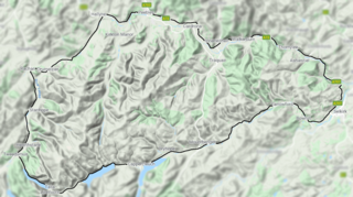
The Moffat Hills are a range of hills in the Southern Uplands of Scotland. They form a roughly triangular shape with a west facing side, a north facing side, and a south-east facing side. It is 17 kilometres from east to west across this triangle and some 16 kilometres north to south. The highest point is White Coomb at 821 m (2694 ft). The town of Moffat lies just south of the Moffat hills and along with Tweedsmuir, at the northern extremity, is the only centre of population around these hills. In some older maps, the northern part of the Moffat Hills is called the Tweedsmuir Hills, but can also be known by the title Manor Hills.

The Cheviot Hills, or sometimes The Cheviots, are a range of uplands straddling the Anglo-Scottish border between Northumberland and the Scottish Borders. The English section is within the Northumberland National Park. The range includes The Cheviot, plus Hedgehope Hill to the east, Windy Gyle to the west, and Cushat Law and Bloodybush Edge to the south.

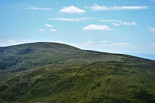
Under Saddle Yoke is a hill in the Moffat Hills range, part of the Southern Uplands of Scotland. Despite its name, it is 10m higher than its neighbouring top, Saddle Yoke. Located in a dramatic position on a small, grassy ridge in between two deep glens, Blackhope and Carrifran, it awards excellent views into the rest of the Moffat Hills and the Ettrick Hills opposite. Although incomparable to the Scottish Highlands and not particularly precipitous, the ridge between and atop the Yokes is the narrowest summit ridge in the Southern Uplands. The electric fence that comes out of Blackshope and crosses the ridge to the north of Saddle Yoke and then continues down into Carrifran hasn't worked in 40 years. A popular round known as the Hart Fell Horseshoe begins near Blackshope and normally ascends Nether Coomb Craig first, then passing over Swatte Fell, Hart Fell and looping round Hartfell Rig to the Saddle Yokes before the descent.

Caher West Top at 973.4 metres, is the fifth-highest peak in Ireland on the Irish Vandeleur-Lynam classification, and part of the MacGillycuddy's Reeks range. Caher West Top is the only Furth to have a prominence below 30 metres (98 ft).

The Bones, at 957 metres (3,140 ft) high, is the seventh-highest peak in Ireland on the Arderin list, or the eighth-highest according to the Vandeleur-Lynam list. It is part of the MacGillycuddy's Reeks in County Kerry, and is a small sharp peak on the dramatic Beenkeragh Ridge, and is sometimes mistaken with The Bone, the north-east spur of Maolán Buí, which descends into the Hag's Glen.

Cruach Mhór, at 932 metres (3,058 ft) high, is the tenth-highest peak in Ireland on the Arderin list, and the eleventh-highest peak in Ireland according to the Vandeleur-Lynam list. A distinctive square grotto marks the summit. It is part of the MacGillycuddy's Reeks in County Kerry.

Hart Fell is a hill in the Moffat Hills range, part of the Southern Uplands of Scotland. It lies north of the town of Moffat on the border with the Scottish Borders and Dumfries and Galloway.

Windlestraw Law is a hill in the Moorfoot Hills range, part of the Southern Uplands of Scotland. It is the highest peak of the range, and lies north of the town of Innerleithen in the Scottish Borders. A large and boggy peak, it is usually climbed from either its western slopes or the longer route from Tweeddale to the south.
The Manor Hills, also known as the Tweedsmuir Hills, are a range of hills south of Peebles in the Scottish Borders, one of the ranges which collectively form the Southern Uplands. They are separated from the Moffat Hills by the Talla Reservoir, Megget Reservoir and St. Mary's Loch, the Moorfoot Hills by the A72 and the Culter Hills in South Lanarkshire by the A701. The western portion of the hills are designated as the 'Tweedsmuir Hills' Site of Special Scientific Interest and the 'Upper Tweeddale' National Scenic Area, with the major tributary rivers designated as Special Areas of Conservation.

Wind Fell is a hill in the Ettrick Hills range, part of the Southern Uplands of Scotland. The Dumfries and Galloway-Scottish Borders border lies across the hill. Close to the Southern Upland Way, routes of ascent frequently incorporate its track and it is almost always climbed along with the neighbouring hills.
Scaw'd Law is a hill in the Lowther Hills range, part of the Southern Uplands of Scotland. The Dumfries and Galloway-South Lanarkshire border runs along its summit, which is notable for having two similar rounded tops; the top 300m to the north is likely the true summit. Surrounded on most sides by tracks or roads, there are various routes to the summit, but the most frequent ascents are from Durisdeer or the Daer Reservoir.

Lousie Wood Law is a hill in the Lowther Hills range, part of the Southern Uplands of Scotland. The terminal northeast Donald on the main ridge in the northern portion of the Lowthers range, it is most easily climbed from its northern and eastern flanks.

Herman Law is a hill in the Ettrick Hills range, part of the Southern Uplands of Scotland. It is the terminal northeast Donald of a ridge that runs parallel to the A708 road on its southern side, also being the last to share the Dumfries and Galloway and Scottish Borders border. It is the least prominent Donald, just qualifying for the necessary 30m of prominence. Usually climbed with the neighbouring hills of the ridge, the most common start point is Birkhill Farm to the west.

The Rhinns of Kells are a range of hills in the Galloway Hills range, part of the Southern Uplands of Scotland. The most easterly of three parallel ridges, they are neighboured to the west by the Range of the Awful Hand and the Dungeon Hills. The eastern portion of the Minnigaff Hills range lies immediately southwest of the range. In total, these four ranges are part of the Galloway Forest Park. The ridge is located entirely within Dumfries and Galloway, with the base of the western flanks being a northwestern boundary of the county.

The Culter Hills, Coulter Fells or variations thereof, are a range of hills, part of the Southern Uplands of Scotland. They are neighboured to the east by the Manor Hills and are split roughly in half by the border between South Lanarkshire and the Scottish Borders.

The Ettrick Hills are a range of hills, part of the Southern Uplands of Scotland. They are neighboured to the northwest by the Moffat Hills and are located mainly within the Scottish Borders, however the Dumfries and Galloway border covers the south and southwesterly flanks.
