
Veghel is a town and a former municipality in the southern Netherlands. On 1 January 2017 Veghel, together with Schijndel and Sint-Oedenrode, merged into a new municipality called Meierijstad creating the largest municipality of the province North-Brabant in terms of land area.

Schijndel is a town and former municipality in the southern Netherlands, in the province of North Brabant. Schijndel is located approximately 14 kilometres (8.7 mi) southeast of 's-Hertogenbosch. Schijndel was founded on 6 December in the year 1309. On 1 January 2017 Schijndel, together with Veghel and Sint-Oedenrode, merged into a new municipality called Meierijstad creating the largest municipality of the province North-Brabant in terms of land area.

Son en Breugel is a municipality in the southern Netherlands just outside Eindhoven. The municipality covers an area of 26.51 km2 (10.24 sq mi) of which 0.56 km2 (0.22 sq mi) is water. It had a population of 16,904 in 2019. Son en Breugel used to be two different villages: 'Son' and 'Breugel', with the stream the Dommel separating the two villages. Son en Breugel also borders the following larger municipalities: Eindhoven, Meierijstad, Nuenen, Gerwen en Nederwetten, and Best. The spoken language is North Meierijs.

Vierlingsbeek is a village in the former municipality of Boxmeer in North Brabant province of the Netherlands. Until it was included in Boxmeer in 1998, it was a municipality of its own. Since 2022 it has been part of the new municipality of Land van Cuijk.

Groeningen is a village in the municipality of Land van Cuijk in the province of North Brabant, Netherlands.

Erp is a village in the southern Netherlands, in the province of North Brabant between 's-Hertogenbosch and Eindhoven. Prior to 1994, Erp was a municipality consisting of the town of Erp and the villages of Boerdonk and Keldonk. In that year, the municipality was merged with the municipality of Veghel to form one municipality under the latter name. The area of the former municipality of Erp has a population of 6,663, while Veghel has a population of 37,655.
Holthees is a village in the former municipality of Boxmeer on the border of the Dutch provinces North Brabant and Limburg. Since 2022 it has been part of the new municipality of Land van Cuijk.

Annen is a village in the Dutch province of Drenthe. Located in the municipality of Aa en Hunze, it lies about 12 km northeast of Assen.

Eexterveen is a village in the Dutch province of Drenthe. It is a part of the municipality of Aa en Hunze, and lies about 17 km east of Assen.
Gieten is a village in the Dutch province of Drenthe. It is a part of the municipality of Aa en Hunze, and lies about 14 km east of Assen.

Eerde is a village in the Dutch province of North Brabant. It is part of the municipality of Meierijstad, located about 500 m west of the built-up area of Veghel and 3 km southwest of the town centre of Veghel. During Operation Market Garden, in September 1944, it changed hands several times between German and American forces but ended up in American hands; the village was severely damaged in the process.

's Gravenmoer is a village in the Dutch province of North Brabant. It is located in the municipality of Dongen, about 3 km north of the town of Dongen. The village has a population of about 2190 inhabitants, including the farmlands to the north of the village.
Haps is a village in the Dutch province of North Brabant. It is located in the former municipality of Cuijk, about 5 kilometres (3.1 mi) south of the town of Cuijk. Since 2022 it has been part of the new municipality of Land van Cuijk.

Loënga is neighbourhood of Sneek and a former village in Súdwest-Fryslân municipality in the province of Friesland, the Netherlands. It has a population of around 95 in January 2017. In 1984, Loënga and Offingawier were annexed by Sneek and are no longer independent villages.
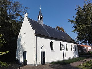
Zwijnsbergen is a hamlet in the municipality of Meierijstad in North Brabant, the Netherlands.

Keldonk is a village in the south of the Netherlands. It is situated in the municipality of Meierijstad, North Brabant.

Zijtaart is a village in the south of the Netherlands. It is situated in the municipality of Meierijstad, North Brabant. As of January 2015 it has a population of 1,727.

Mariaheide is a village in the south of the Netherlands. It is situated in the municipality of Meierijstad, North Brabant.

Meierijstad is a municipality in the province of North Brabant. The municipality is the result of a merger between the municipalities Schijndel, Sint-Oedenrode and Veghel in 2017. After the merger it became the largest municipality in terms of land area of North Brabant. The town of Veghel hosts the town hall, while the municipal council holds its meetings at the former town hall of Sint-Oedenrode.
Maashorst is a municipality in the province of North Brabant, the Netherlands, formed from the merger of Landerd and Uden. The municipality came into existence on 1 January 2022. The name Maashorst refers to the nature reserve of the same name, which lies between the various village centres. The eastern part belongs to the region of De Peel.


