Veghel is a town and a former municipality in the southern Netherlands. On 1 January 2017 Veghel, together with Schijndel and Sint-Oedenrode, merged into a new municipality called Meierijstad creating the largest municipality of the province North-Brabant in terms of land area.

Sint-Oedenrode is a town in the province of North Brabant.
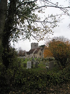
Much Hadham, formerly known as Great Hadham, is a village and civil parish in the district of East Hertfordshire, Hertfordshire, England. The parish of Much Hadham contains the hamlets of Perry Green and Green Tye, as well as the village of Much Hadham itself and Hadham Cross. It covers 4,490 acres (1,820 ha). The village of Much Hadham is situated midway between Ware and Bishop's Stortford. The population of the parish was recorded as 2,087 in the 2011 census, an increase from 1,994 in 2001.

Erp is a village in the southern Netherlands, in the province of North Brabant between 's-Hertogenbosch and Eindhoven. Prior to 1994, Erp was a municipality consisting of the town of Erp and the villages of Boerdonk and Keldonk. In that year, the municipality was merged with the municipality of Veghel to form one municipality under the latter name. The area of the former municipality of Erp has a population of 6,663, while Veghel has a population of 37,655.

Crowhurst is an isolated village situated five miles (8 km) north-west of Hastings in East Sussex. It has a parish council and is located within the Rother District Council.

Beachamwell is a village and civil parish in the Breckland district of Norfolk, England about 5 miles (8.0 km) south west of Swaffham and 10 miles (16 km) east of Downham Market. It has four ancient churches, two of them in ruins. The former parish of Shingham has been annexed.

Boyton is a village and civil parish in Wiltshire, England. It lies in the Wylye Valley within Salisbury Plain, about 6 miles (10 km) south-east of Warminster and 13 miles (21 km) north-west of Salisbury. The parish includes the village of Corton.

Broughton is a village and civil parish in the City of Preston, Lancashire, England, approximately 4 miles (6 km) north of Preston city centre. According to the 2001 census it had a population of 1,735, decreasing to 1,722 at the 2011 Census. The parish is included in Preston Rural East ward of Preston city council, and the Preston Rural division of Lancashire County council.

St Ive is a village in the civil parish of St Ive and Pensilva in eastern Cornwall, England, United Kingdom. The village is split into four parts: St Ive Church End, St Ive Cross, St Ive Keason and St Ive Parkfield. In addition to the parish an electoral ward exists stretching north of St Ive. The population at the 2011 census was 4,246.

Colerne is a village and civil parish in north Wiltshire, England. The village is about 3.5 miles (6 km) west of the town of Corsham and 7 miles (11 km) northeast of the city of Bath. It has an elevated and exposed position, 545 feet (166 m) above sea level, and overlooks the Box valley to the south.

Lanlivery is a village and civil parish in Cornwall, England, United Kingdom. The village is about 1+1⁄2 miles (2.4 km) west of Lostwithiel and five miles (8 km) south of Bodmin. The Saints' Way runs past Lanlivery. Helman Tor, Red Moor and Breney Common nature reserves lie within the parish.
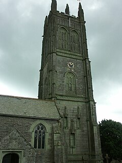
Probus is a civil parish and village in Cornwall, England, in the United Kingdom. It has the tallest church tower in Cornwall. The tower is 129 feet (39 m) high, and richly decorated with carvings. The place name originates from the church's dedication to Saint Probus. The parish population at the 2011 census was 2,299, whereas the ward population taken at the same census was 3,953.
Heckington is a village and civil parish in the North Kesteven district of Lincolnshire, England. It is situated between Sleaford and Swineshead Bridge, and south of the A17 road. Heckington, with 1,491 households, is one of the largest villages in Lincolnshire.. The population of the civil parish including Boughton was 3,353 at the 2011 census.

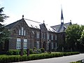
Eerde is a village in the Dutch province of North Brabant. It is part of the municipality of Meierijstad, located about 500 m west of the built-up area of Veghel and 3 km southwest of the town centre of Veghel. During Operation Market Garden, in September 1944, it changed hands several times between German and American forces but ended up in American hands; the village was severely damaged in the process.

St Mary's Church is an active Anglican parish church located in Monk's Lane, Acton, a village to the west of Nantwich, Cheshire, England. Since 1967 it has been designated a Grade I listed building. A church has been present on this site since before the time of the Domesday Survey. The tower is the oldest in Cheshire, although it had to be largely rebuilt after it fell in 1757. One unusual feature of the interior of the church is that the old stone seating around its sides has been retained. In the south aisle are some ancient carved stones dating back to the Norman era. The architectural historian Alec Clifton-Taylor includes the church in his list of 'best' English parish churches. In the churchyard is a tall 17th-century sundial. The church is an active Anglican parish church in the diocese of Chester, the archdeaconry of Macclesfield and the deanery of Nantwich. Its benefice is united with those of St David, Wettenhall, St Oswald, Worleston, and St Bartholomew, Church Minshull.

St Wilfrid's Church stands to the north of the village of Mobberley, Cheshire, England. The church is recorded in the National Heritage List for England as a designated Grade I listed building. It is an active Anglican parish church in the diocese of Chester, the archdeaconry of Macclesfield and the deanery of Knutsford. Alec Clifton-Taylor includes it in his list of 'best' English parish churches.
Funtington is a village and civil parish in the Chichester district of West Sussex, England. It lies on the B2146 Road 4.5 miles (7.2 km) west of Chichester. The parish also contains the villages of East and West Ashling, West Stoke and the Kingley Vale National Nature Reserve lies at its northern tip. There is a farm produce shop and a pub at the centre of the village. Funtington Primary School is in the village of West Ashling.

St Wilfrid's Church is an Anglican church in Halton-on-Lune, a village in the English county of Lancashire. It is an active parish church in the Diocese of Blackburn and the archdeaconry of Lancaster. Halton may have been the site of an ancient Anglo-Saxon minster. Of the current structure, the tower dates from the 16th century and the remainder was built 1876–77 by Paley and Austin. The church is recorded in the National Heritage List for England as a designated Grade II listed building.

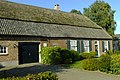
Nijnsel is a village in the province of North Brabant, located in the Meierij of 's-Hertogenbosch. Nijnsel is a parish of the municipality of Meierijstad.

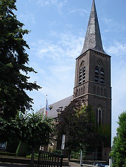
Mariaheide is a village in the south of the Netherlands. It is situated in the municipality of Meierijstad, North Brabant.