Sangareddy, is a city and district headquarters of the Sangareddy district in the Indian state of Telangana. It was named after the ruler Sanga, who was the son of Rani Shankaramba, a ruler of Medak during the period of Nizams.

Nizamabad district is a district located in the north-western region in the Indian state of Telangana. The city of Nizamabad is the district headquarters.It was known as " Indur " which was supposed to have originated from the name of the King was Indradatta who seems to have flourished it during the 5th century A.D.The district share boundaries with Jagtial, Sircilla, Nirmal, Kamareddy districts and with Nanded district of the state boundary of Maharashtra.

Peddapalli is a town and Revenue Division in Peddapalli District in the Indian state of Telangana. It is the headquarters of the Peddapalli District and Peddapalli mandal. It is located about 197 kilometres North of the state capital Hyderabad, 36 kilometres from Karimnagar, 28 kilometres from Ramagundam. Peddapalli has a railway junction named PDPL which connects PDPL - KRMR - NZB railway line and New Delhi (NDLS) - Chennai Central (MAS) railway line. There are two trains that terminate here. Karimnagar Tirupati express rail engine changes to electric engine here. As of 2011 census of India, Peddapalli has a population of 41,171. In 2016 due to population Increase, the civic body of Peddapalli was upgraded from Nagar Panchayat to Municipal council Post upgradation to Council.

Ghatkesar is a satellite town of Hyderabad in the Medchal-Malkajgiri district of Telangana, India. It is the Mandal headquarters of Ghatkesar Mandal in The Keesara revenue division. Located in the outer suburbs of Hyderabad, it is a part of The Hyderabad Metropolitan Development Authority.
Chevella is a town, mandal and suburb of Hyderabad in Ranga Reddy district of the Indian state of Telangana. It is the headquarters of surrounding villages with many government establishments like Judicial court, Revenue Division Office, Acp office under Cyberabad Metropolitan Police. It is also an educational hub with many schools, junior colleges, engineering colleges, business schools etc. There are many hospitals located along with a medical college, the Dr. Patnam Reddy Institute of Medical Sciences. It has become a part of Hyderabad Metropolitan Development Authority.
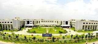
The Sreenidhi Institute of Science and Technology is a private college located in Hyderabad, Telangana, India. The college is affiliated to the Jawaharlal Nehru Technological University, Hyderabad (JNTUH). In the year 2010-11, the institution attained autonomous status and it is the first college under JNTUH to get that status.
Kamalapur Town or sometimes Kamalapuram is a Mandal of Hanumakonda district in the state of Telangana in India.It is located nearer to town Warangal the city of kakatiyas.It is close to Kakatiya university.

Nizampet is a satellite city of Hyderabad and a municipal corporation situated in Bachupally mandal, Medchal-Malkajgiri district of Telangana, India. It is administered as Nizampet Municipal Corporation.

Habsiguda is a neighbourhood in Hyderabad, Telangana, India. It is located at the eastern end of the city between Tarnaka and Uppal. It forms Ward No. 7 of Greater Hyderabad Municipal Corporation.
Afzal Gunj is one of the part in Old City, Hyderabad, Telangana, India, close to river Musi. Afzal Gunj is the hub of local transportation due to the presence of Central Bus Station in the region. The bus station provides services to most of parts in the city.

Sri Lakshmi Narasimha Swamy Temple or simply known as Yadadri or Yadagirigutta temple, is a Hindu temple situated on a hillock in the small town of Yadagirigutta in the Yadadri Bhuvanagiri district of the Indian state of Telangana. The temple is an abode of Narasimha, an incarnation of Lord Vishnu.
Yadagirigutta is a census town in Alair Assembly constituency of Yadadri Bhuvanagiri district of the Indian state of Telangana. It is a temple town as the famous Lakshmi Narasimha Temple is situated here. It is located at a distance of 16 Kms from the district headquarters Bhuvanagiri which is a part of Hyderabad Metropolitan Region and 55 Kms from Uppal, a major suburb of Hyderabad. The proposed Hyderabad Regional Ring Road passes through Yadagirigutta.

Telangana University is a public university located at Dichpally in Nizamabad,Telangana, India, established in 2006.
A. S. Rao Nagar, also known as Dr. A. S. Rao Nagar, is a major commercial and residential neighbourhood of Hyderabad, Telangana, India. It is located in the north eastern side of the city falling under Kapra Village & Mandal, Medchal-Malkajgiri district. It is administered as Ward No. 2 of Greater Hyderabad Municipal Corporation.
Dammaiguda formally known as Dammaigudem which earlier it was Hamlet Village in Nagaram Revenue Village then later burificated as a Separate Gram Panchayat. outer suburb of Hyderabad in Medchal-Malkajgiri district in Telangana, India. It falls under Keesara mandal. It is a residential neighbourhood with a lot of independent houses and upcoming real-estate projects.. It comes under Jawaharnagar police station which is just 2 km from Dammaiguda Rajiv crossroad. it is one of the fastest developing areas in Hyderabad.
Nagaram is a formally known as Naagavaram Suburb of Hyderabad and a municipality in Telangana, India. And it also the largest Revenue Village falls under Keesara mandal of Medchal-Malkajgiri district. Due to its proximity to ECIL Company, Secunderabad and Eastern IT/SEZ of Hyderabad Pocharam, it is emerging as a major residential location in Hyderabad.

Boduppal is a satellite city of Hyderabad and a municipal corporation in Medchal–Malkajgiri District of Telangana, India. It is administered by Boduppal Municipal Corporation. Located at the eastern end of the Hyderabad City, it is spread between Nacharam-Mallapur Road and Warangal Highway NH 163. Due to its proximity to Secunderabad and Eastern IT/SEZ of Pocharam, it is emerging as a major residential location in Hyderabad.
Narapally is a village under Pocharam Municipality in Medchal-Malkajgiri District in Telangana, India. It falls under Ghatkesar mandal. Narapally is an upcoming residential and commercial suburban area due its close proximity to Singapore Township and Raheja Mindspace. It is on the National Highway 163.
BHEL Township, Hyderabad is a suburb of Hyderabad, Telangana. This has developed like other BHEL townships after Indian public sector engineering company BHEL started its operations here. Township is well known for its greenery and lush green campus. Large numbers of quarters with full amenities. Hostels for ET's, Assistant Engineers and artisans have good facilities. It is spread over an area of around 16 km2 and provides facilities like, parks, community halls, sports complex, grounds, library, shopping centers, banks, and post offices. Free health services are extended to all the employees and their dependents through BHEL run hospital.
Kommuri Pratap Reddy Institute of Technology (KPRIT) is a college in Ghatkesar, Telangana. It was founded by K Pratap Reddy in 2008. Sri K Pratap Reddy is a member of the Legislative assembly as well as an educationalist and philanthropist. Established in 2008, KPRIT is located on an area of 22 acre site adjacent to NTPC power grid near Ghanpur Village, Ghatkesar Mandal. KPRIT is just 9 kilometers (5.0 mi) from UPPAL bus depot and 1 km from the outer ring road. The institution is recognised by All India Council for Technical Education, New Delhi and affiliated to JNTUH.

