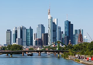
Frankfurt, officially Frankfurt am Main, is the most populous city in the German state of Hesse. Its 763,380 inhabitants as of 31 December 2019 make it the fifth-most populous city in Germany. On the river Main, it forms a continuous conurbation with the neighboring city of Offenbach am Main and its urban area has a population of 2.3 million. The city is the heart of the larger Rhine-Main Metropolitan Region, which has a population of 5.5 million and is Germany's second-largest metropolitan region after the Rhine-Ruhr Region. Frankfurt's central business district lies about 90 km (56 mi) northwest of the geographic center of the EU at Gadheim, Lower Franconia. Like France and Franconia, the city is named after the Franks. Frankfurt is the largest city in the Rhine Franconian dialect area.

Oberursel (Taunus) is a town in Germany and part of the Frankfurt Rhein-Main urban area. It is located to the north west of Frankfurt, in the Hochtaunuskreis county. It is the 13th largest town in Hesse. In 2011, the town hosted the 51st Hessentag state festival.
Melchior Acontius was a German poet.
Oberstedten is one of four town subdivisions (Stadtteile) and one of three boroughs (Ortsbezirke) of Oberursel, located north of the core city and immediately northwest of Frankfurt am Main in Germany. It is part of the Frankfurt Rhein-Main urban area at the border of Bad Homburg.

Kronberg im Taunus is a town in the Hochtaunuskreis district, Hesse, Germany and part of the Frankfurt Rhein-Main urban area. Before 1866, it was in the Duchy of Nassau; in that year the whole Duchy was absorbed into Prussia. Kronberg lies at the foot of the Taunus, flanked in the north and southwest by forests. A mineral water spring also rises in the town.

Friedrichsdorf is a town of the Hochtaunuskreis, some 20 km (12 mi) north of Frankfurt am Main in Hesse, Germany.
The Frankfurt International School e.V. (FIS) is an English-language day school founded in 1961 in Frankfurt, but located in Oberursel, Germany.

Nieder-Erlenbach is since 1 August 1972 the northernmost borough (Ortsbezirk) of Frankfurt am Main, Germany.
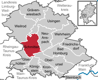
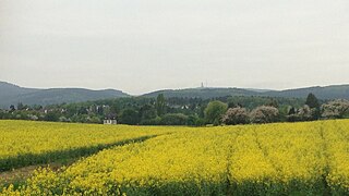
Schmitten is a climatic spa and municipality in the Hochtaunuskreis in Hessen, Germany.
The Wetterau is a fertile undulating tract, watered by the Wetter, a tributary of the Nidda River, in the western German state of Hesse, between the hilly province Oberhessen and the north-western Taunus mountains.
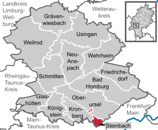
Steinbach is a town in the Hochtaunuskreis that borders Frankfurt am Main to the east. Other neighbouring towns are Oberursel, Kronberg im Taunus and Eschborn. It is in the German state of Hesse.
Camp King is a site on the outskirts of Oberursel, Taunus, with a long history. It began as a school for agriculture under the auspices of the University of Frankfurt. During World War II, the lower fields became an interrogation center for the German Air Force. After World War II, the United States Army also used it as an interrogation center and intelligence post. In 1968, it became the command and control center for the United States Army Movements Control Agency - Europe (USAMCAEUR). Today it has been rebuilt as a German housing area.
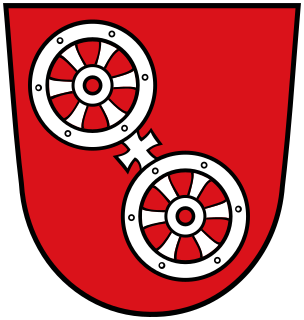
The Wheel of Mainz or Mainzer Rad, in German, was the coat of arms of the Archbishopric of Mainz and thus also of the Electorate of Mainz (Kurmainz), in Rhineland-Palatinate, Germany. It consists of a silver wheel with six spokes on a red background. The wheel can also be found in stonemasons' carvings and similar objects. Currently, the City of Mainz uses a double wheel connected by a silver cross.

Bundesautobahn 661 - also called Osttangente Frankfurt or Taunusschnellweg - is a 40 km (25 mi) long Autobahn in Germany. It starts in Oberursel and goes along Bad Homburg, Frankfurt am Main, Offenbach am Main and Neu-Isenburg until it is ending in Egelsbach.

The Frankfurt am Main tramway network is a network of tramways forming a major part of the public transport system in Frankfurt am Main, a city in the federal state of Hesse, Germany.

Bundesstraße 455 is a German Bundesstraße in the federal state of Hesse. The route runs southwest from Schotten in Vogelsbergkreis to Mainz-Kastel, a borough of the Hessian capital city of Wiesbaden.

The Homburg Railway is an 18 km line from Frankfurt am Main to Bad Homburg in the German state of Hesse. It was opened in 1860 as one of the first railway lines in Germany. It is now part of the Rhine-Main S-Bahn line S5 to Friedrichsdorf.

Oberursel (Taunus) station is a station on S-Bahn line S5 in Oberursel (Taunus), near Frankfurt am Main, Germany on the Homburg line. The former Mountain Railway ran from the station to Hohemark; it is now part of U-Bahn line U3.

The A line is the north-to-south main line of the Frankfurt U-Bahn. It is the oldest and longest line of the U-Bahn system. Served by four routes starting at Südbahnhof Railway Station in Sachenhausen, the A line runs through downtown Frankfurt up to Heddernheim Station in the north of the city, where it branches out to Ginnheim, Oberursel (U3), Riedberg and Bad Homburg (U2). The U9 service between Ginnheim, Riedberg and Nieder-Eschbach does not use the central section and tunnels of the line, making it the only light rail service of the network that does not serve downtown Frankfurt. The Riedberg and Ginnheim branches were planned as parts of the future D line subway but are operationally part of the A line until the D line development and construction is finished.

Aureus of Mainz is a Roman Catholic saint and the first named bishop of Mainz. His feast is on 16 June.


