Usingen

Last updated
Usingen
Gesamtanlage Usingen.jpg
City centre
Flagge Usingen.svg
DEU Usingen Banner.svg
DEU Usingen COA.svg
Location of Usingen within Hochtaunuskreis district
Usingen in HG.svgGlashütten
Germany adm location map.svg
Red pog.svg
Usingen
Hesse location map.svg
Red pog.svg
Usingen
Coordinates: 50°20′04″N8°32′15″E / 50.33444°N 8.53750°E / 50.33444; 8.53750 Coordinates: 50°20′04″N8°32′15″E / 50.33444°N 8.53750°E / 50.33444; 8.53750
Country Germany
State Hesse
Admin. region Darmstadt
District Hochtaunuskreis
Subdivisions7 Stadtteile
Government
   Mayor (202228) Steffen Wernard [1] (CDU)
Area
  Total55.83 km2 (21.56 sq mi)
Elevation
269 m (883 ft)
Population
 (2020-12-31) [2]
  Total14,722
  Density260/km2 (680/sq mi)
Time zone UTC+01:00 (CET)
  Summer (DST) UTC+02:00 (CEST)
Postal codes
61250
Dialling codes 06081
Vehicle registration HG, USI
Website www.usingen.de

Usingen is a small town in the Hochtaunuskreis in Hessen, Germany. Until 1972, this residential and school town was the seat of the former district of Usingen.

Contents

Coat of arms

Seal around 1900 Siegelmarke Stadt Usingen - Preussen W0229250.jpg
Seal around 1900

The earliest seal whose appearance is known – there had been earlier ones, but what they looked like is unknown – dates from 1277 and shows the four lions (golden ones denoting Nassau; silver ones denoting Saarbrücken), since the town was ruled then by the Counts of Nassau-Saarbrücken. Later seals did not show the billets and crosses with which the fields are spangled, but they reappeared in 1935, when the current arms were conferred. An earlier town symbol, a cloverleaf (or heraldically, a trefoil), may explain the charge on the inescutcheon. This was also added to the arms in 1935. [3]

Geography

Geographical setting

Usingen lies on the Usa River in the Usinger Becken at the north-eastern edge of the Taunus. It is located about 30 km north of Frankfurt am Main, 27 km south of Wetzlar and 38 km northeast of Wiesbaden, putting it on the edge of the Frankfurt Rhein-Main Region.

The town core is about 300 m above sea level. The highest elevation in the main town of Usingen is the Hohe Berg ("High Mountain"), 414 m above sea level.

Neighbouring communities

Usingen borders in the north and east on the Wetteraukreis (town of Butzbach and community of Ober-Mörlen), in the southeast on the community of Wehrheim, in the south on the town of Neu-Anspach and the community of Schmitten, in the west on the community of Weilrod and in the northwest on the community of Grävenwiesbach.

History

Usingen (Latin Osinga), which in Frankish times likely existed as a fortified stopping place at an old crossroads, was first mentioned in the Codex Eberhardi , a manuscript from the Fulda monastery, and it is generally accepted that references made to the town go back to between 754 and 802. Archaeological proof of a settlement on the modern town's site back in Carolingian times has yet to be unearthed, although, not far from town, the remains of a Carolingian courtyard were once dug up. The possibility therefore exists that today's Usingen might not lie on the same spot as it once did, having relocated at some time in the past. More investigation will be needed before this is ascertained.

In 1207, being on the outskirts of the Usinger Land, it passed into the ownership of the Counts of Diez, who had acquired this Imperial estate in exchange for Mainz-Kastell (fort).

A Nassau castle – in 1326, the Counts of Nassau had acquired the Usinger Land by pledge, and by 1405 for good – on the site of today's Christian-Wirth-Schule (school) and a wall with five towers protected this small weaving town in the Middle Ages.

It is likely that Usingen was granted town rights in the 14th century.

As of 1659, the Counts resided in the castle, now converted into a stately home with a lovely garden, and from 1688 to 1744 the Princes of Nassau-Usingen lived there.

One prominent personage in Usingen's history was Fürst (Prince) Walrad. When Nassau-Saarbrücken lands were being divided up on 31 March 1659, Count Walrad got the Usinger Land. He governed for 43 years and was a respected commander, among other things field marshal of the Dutch States Army under William III of Orange. His period of rule was a decisive factor in making Usingen the way it is today, since after the Thirty Years' War and the three town fires in the 17th century – with their attendant drop in population – he settled Huguenots in the town and had the New Town built.

Another personage worthy of note was the violinist August Wilhelmj. He was made an honorary citizen of Usingen on 31 March 1876 on the occasion of his last concert in the town of his birth – Usingen. He was born there on 21 September 1845. The house where he was born stood at the lower end of the Rathauspassage, now called Wilhelmjstraße in his honour. On the lot where the house stood, where a bank building now stands, a memorial stone with a plaque recalls the important violinist.

Usingen was until 1886 the seat of an Amt and thereafter, until 1972 a district seat. The scant industrial development in modern times could not even be strengthened by the railway connection that came in 1895. Usingen has been since the time of the Reformation a school town: Latin school until 1817, teachers' college from 1851 to 1926, Christian-Wirth-Schule (Gymnasium) since 1926 – today together with many other kinds of school.

As part of municipal reform, the communities of Usingen, Eschbach, Kransberg, Merzhausen, Michelbach, Wernborn and Wilhelmsdorf merged in 1972 into the town of Usingen. Even after losing its function as district seat (Usingen district was merged with Obertaunus district to form the Hochtaunuskreis with its seat at Bad Homburg) Usingen is more than ever the midpoint of the Usinger Land.

Politics

Town council

SPD CDU Greens FDP BEUFWG
20068203222

Note: FWG is a citizens' coalition.

Partnerships

Usingen maintains partnerships with the following places:

Sightseeing

Usinger Schloss

Schloss Usingen Usingen Schlossanlage.jpg
Schloss Usingen

In the middle of downtown Usingen is Usingen's stately home, the Usinger Schloss. The home's exact origins have yet to be fully explained. It is assumed that it was built in the 14th century as a castle under Johann I of Nassau-Weilburg. Prince Walrad had a new stately home built on the castle's site in 1660–1663. The architect Friedrich Joachim Stengel (1694–1787) remodelled the Usinger Schloss into a Baroque residence between 1733 and 1738 as instructed by Princess Charlotte Amalie, Prince Wilhelm Heinrich I's widow. In 1873, a great fire destroyed the Schloss, which was afterwards built anew.

Evangelische Laurentiuskirche Usingen Kirchgasse 12.jpg
Evangelische Laurentiuskirche

Today it is used as a Gymnasium (Christian-Wirth-Schule). Bordering right on the Schloss is the Usinger Schlossgarten, the stately home garden.

Evangelische Laurentiuskirche

The main church of Usingen is the Evangelische Laurentiuskirche.

Huguenot church with marketplace

Huguenot church with marketplace Using, Marktplatz 21, 23, 25-20160428-001.jpg
Huguenot church with marketplace

Another great fire in 1692 destroyed the so-called Usinger Oberstadt (Upper Town). The overlord at that time, Prince Walrad (1635–1702) gave orders for its prompt reconstruction. Symmetrical rows of houses, which still form the townscape now, were built, and along the Obergasse (Upper Lane) appeared representative buildings. The so-called New Town's heart was shaped by the Hugenottenkirche with what is nowadays the old marketplace. Benedikt Burtscher was the building master of the church, built in 1700 and showing in its building style certain commonalities with the well known church at La Rochelle. After the Huguenot church fell out of use with the union of the Lutheran Protestants and the Reformed Church, it was soon converted into a school. Today, however, it houses the Usingen library. On the upper floors are found many places where concerts and gatherings can be accommodated. The wedding room is a favourite place for couples to plight their troth.

Eschbacher Klippen

Eschbacher Klippen Eschbacher-Klippen-Dezember-2016.jpg
Eschbacher Klippen

At the north end of Eschbach stands a group of cliffs up to 12 m high and made of quartz. The cliff wall is the visible part of a roughly six-kilometre-long quartz seam which continues slantwise across the Usa Valley to the Wormstein in Usingen town forest. From a geological standpoint, it is an oblique upthrow (fault with one side thrust up higher than the other) formed by faulting in the mountain range. The erosion-resistant quartz has lasted to this day and can be seen in many places in the Taunus, but nowhere is it more spectacular than here.

Climbers use the steeper walls for training.

Hattsteinweiher

Hattsteinweiher Hattsteinweiher Usingen.jpg
Hattsteinweiher

The Hattsteinweiher near Usingen is the only bathing lake in the Usinger Land. In summer, when the weather is good, it is the centre of attraction for many visitors from the Taunus and the Frankfurt Rhein-Main Region.

Economy and infrastructure

Public transport

Usingen station has at its disposal a good connection to the public railway network. Whereas railway lines have been closed elsewhere, things have gone the other way in the Hochtaunuskreis. The line that has connected the Usinger Land to Frankfurt since 1895 has been run since 1993 by the district as the Taunusbahn . At peak hours, the trains run half-hourly, and otherwise hourly, to Bad Homburg. Peak hours also bring hourly through trains to Frankfurt's main railway station. Service stops at about 23:00 (0:00 on Saturday nights).

Further infrastructure

Usingen is the seat of an Amtsgericht (local district court) and home to a hospital.

Antenna farm

Satellite station and antenna farm Erdfunksendestelle Usingen.jpg
Satellite station and antenna farm

Usingen is home to a ground station with satellite dishes and various other antennas run by T-Systems. After the Second World War, during which the property had been used as an aerodrome, a shortwave transmission station was built here. In 1979 came the first big parabolic antenna. The station now houses more than 90 antennas, among them three dishes measuring 19 m across.

Regular events

Known far beyond Usingen's borders are the yearly Usinger Flohmarkt (flea market) in late June and the Usinger Laurentiusmarkt, every second weekend in September.

Literature

Related Research Articles

<span class="mw-page-title-main">County of Nassau</span> State of the Holy Roman Empire (1125–1806)

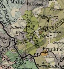
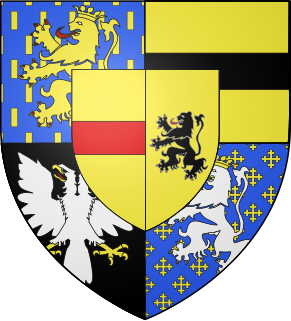
The County of Nassau was a German state within the Holy Roman Empire and later part of the German Confederation. Its ruling dynasty, the male line of which is now extinct, was the House of Nassau.

<span class="mw-page-title-main">Taunus</span> Mountain range in Germany

The Taunus is a mountain range in Hesse, Germany, located north of Frankfurt. The tallest peak in the range is Großer Feldberg at 878 m; other notable peaks are Kleiner Feldberg and Altkönig.

The Hochtaunuskreis is a Kreis (district) in the middle of Hesse, Germany and is part of the Frankfurt/Rhine-Main Metropolitan Region. Neighbouring districts are Lahn-Dill, Wetteraukreis, district-free Frankfurt, Main-Taunus, Rheingau-Taunus, Limburg-Weilburg.

<span class="mw-page-title-main">Idstein</span> Town in Hesse, Germany

Idstein is a town of about 25,000 inhabitants in the Rheingau-Taunus-Kreis in the Regierungsbezirk of Darmstadt in Hesse, Germany. Because of its well preserved historical Altstadt it is part of the Deutsche Fachwerkstraße, connecting towns with fine fachwerk buildings and houses. In 2002, the town hosted the 42nd Hessentag state festival.

<span class="mw-page-title-main">Siegen</span> City in North Rhine-Westphalia, Germany

Siegen is a city in Germany, in the south Westphalian part of North Rhine-Westphalia.

<span class="mw-page-title-main">Kronberg im Taunus</span> Town in Hesse, Germany

Kronberg im Taunus is a town in the Hochtaunuskreis district, Hesse, Germany and part of the Frankfurt Rhein-Main urban area. Before 1866, it was in the Duchy of Nassau; in that year the whole Duchy was absorbed into Prussia. Kronberg lies at the foot of the Taunus, flanked in the north and southwest by forests. A mineral water spring also rises in the town.

<span class="mw-page-title-main">Schmitten im Taunus</span> Municipality in Hesse, Germany

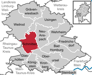
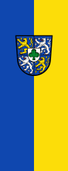
Schmitten im Taunus is a municipality in the Hochtaunuskreis in Hessen, Germany.

<span class="mw-page-title-main">Königstein im Taunus</span> Town in Hesse, Germany

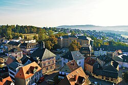
Königstein im Taunus is a health spa and lies on the thickly wooded slopes of the Taunus in Hesse, Germany. The town is part of the Frankfurt Rhein-Main urban area. Owing to its advantageous location for both scenery and transport on the edge of the Frankfurt Rhine Main Region, Königstein is a favourite residential town. Neighbouring places are Kronberg im Taunus, Glashütten, Schwalbach am Taunus, Bad Soden am Taunus and Kelkheim.

<span class="mw-page-title-main">House of Nassau</span> Diversified aristocratic dynasty in Europe

The House of Nassau is a diversified aristocratic dynasty in Europe. It is named after the lordship associated with Nassau Castle, located in present-day Nassau, Rhineland-Palatinate, Germany. The lords of Nassau were originally titled "Count of Nassau", then elevated to the princely class as "Princely Counts". Early on they divided into two main branches: the elder (Walramian) branch, that gave rise to the German king Adolf, and the younger (Ottonian) branch, that gave rise to the Princes of Orange and the monarchs of the Netherlands.

<span class="mw-page-title-main">Wehrheim</span> Municipality in Hesse, Germany

Wehrheim is a municipality in Hesse, Germany some 30 km (20 mi) north of Frankfurt am Main.

<span class="mw-page-title-main">Bad Camberg</span> Town in Hesse, Germany

Bad Camberg is, with 15,000 inhabitants, the second largest town in Limburg-Weilburg district in Hesse, Germany, as well as the southernmost town in the Regierungsbezirk of Gießen. It is located in the eastern Taunus in the Goldener Grund some 30 km north of Wiesbaden, 18 km southeast of Limburg an der Lahn, and 44 km northwest of Frankfurt, as well as on the German Timber-Frame Road. Bad Camberg is the central community of the Goldener Grund with good infrastructure, and a lower centre partly with a middle centre's function.

The Taunus Railway in the High Taunus is a railway route between Frankfurt (Main) Hauptbahnhof and Brandoberndorf via Bad Homburg, Usingen and Grävenwiesbach. It was operated from 1993 to 1995 by the Frankfurter Verkehrsverbund as the T-Bahn and subsequently by the Rhein-Main-Verkehrsverbund as line 15. It is listed in table 637 of the Deutsche Bahn timetable. The Friedrichsdorf–Brandoberndorf line, which has the infrastructure number of 9374, forms part of the old Friedrichsdorf–Wetzlar line, which was known as the Taunusbahn. The line is owned by the Verkehrsverband Hochtaunus. The infrastructure is managed by HLB Basis AG on behalf of the VHT.

<span class="mw-page-title-main">Biebrich Palace</span> Baroque residence in Hesse, Germany built in 1702

Biebrich Palace is a Baroque residence (Schloss) in the borough of Biebrich in the city of Wiesbaden, Hesse, Germany. Built in 1702 by Prince Georg August Samuel of Nassau-Idstein, it served as the ducal residence for the independent Duchy of Nassau from 1816 until 1866.

<span class="mw-page-title-main">William Louis, Count of Nassau-Saarbrücken</span>

William Louis of Nassau-Saarbrücken, was a Count of Saarbrücken.

<span class="mw-page-title-main">Walrad, Prince of Nassau-Usingen</span>

Walrad Usingen of Nassau, was from 1659 Count, and from 1688 Prince of Nassau-Usingen and founder of Usingen line of the House of Nassau.

<span class="mw-page-title-main">Charles, Prince of Nassau-Usingen</span>

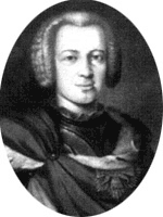
Charles, Prince of Nassau-Usingen, was Prince of Nassau-Usingen from 1718 to 1775.

Philip III, Count of Nassau-Weilburg was a Count of the Nassau-Weilburg. Among his major achievements were the introduction of the Reformation, the foundation of the Gymnasium Philippinum in Weilburg and the start of the construction of Schloss Weilburg.

Eschbach is a borough of Usingen in the Hochtaunuskreis in Hessen. The once almost entirely agriculturally based village at the northern edge of the Usinger Becken first appeared in 1280 in the County Cleeberg under the name of Ketteneschbach. The current district of Usingen was known far beyond the Taunus already early through good catering, later through the campsite in the forest and the former weekend-settlement below the Eschbacher Klippen.

<span class="mw-page-title-main">Usingen station</span>

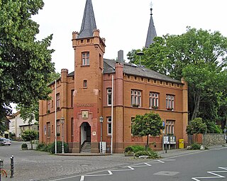
Usingen station is the station of Usingen in the German state of Hesse) and the operations centre of the Taunus Railway from Brandoberndorf via Grävenwiesbach and Usingen to Bad Homburg. The entrance building is heritage-listed.

<span class="mw-page-title-main">Grävenwiesbach station</span>

Grävenwiesbach station is the station of Grävenwiesbach on the edge of the Hochtaunuskreis in the German state of Hesse. It is located on the southern outskirts of the town centre. Previously, the station was a junction station that served trains running on the Weil Valley Railway to Weilburg via Weilmünster, on the Taunus Railway to Bad Homburg and on the Solms Valley Railway to Wetzlar.

References

Citations