Steinbach (Taunus)

Last updated
Steinbach
DEU Steinbach (Taunus) Banner.svg
DEU Steinbach (Taunus) COA.svg
Location of Steinbach (Taunus) within Hochtaunuskreis district
Steinbach (Taunus) in HG.svgGlashütten
Germany adm location map.svg
Red pog.svg
Steinbach
Hesse location map.svg
Red pog.svg
Steinbach
Coordinates: 50°10′N8°34′E / 50.167°N 8.567°E / 50.167; 8.567
Country Germany
State Hesse
Admin. region Darmstadt
District Hochtaunuskreis
Government
   Mayor (201925) Steffen Bonk [1] (CDU)
Area
  Total4.4 km2 (1.7 sq mi)
Highest elevation
200 m (700 ft)
Lowest elevation
150 m (490 ft)
Population
 (2022-12-31) [2]
  Total10,846
  Density2,500/km2 (6,400/sq mi)
Time zone UTC+01:00 (CET)
  Summer (DST) UTC+02:00 (CEST)
Postal codes
61449
Dialling codes 06171
Vehicle registration HG, USI
Website www.stadt-steinbach.de

Steinbach is a town in the Hochtaunuskreis that borders Frankfurt am Main to the east. Other neighbouring towns are Oberursel, Kronberg im Taunus and Eschborn. It is in the German state of Hesse.

Contents

Geography

Location

Steinbach lies at a height of 166 metres above sea level in the hills of the Anterior Taunus and on the edge of the Taunus Nature Park. It is about 7 km from Frankfurt's city boundary and 7.5 km southwest of Bad Homburg vor der Höhe. The mountains of Altkönig (798 m) and Feldberg (879 m) to the northwest are within the line of sight. Under clear conditions, the Odenwald can be distinguished in the southwest. To the south is the Frankfurt skyline and, under a sunny weather, the Staudinger power station in Großkrotzenburg can be seen.

Neighbouring communities

Steinbach is bordered in the north by the town of Oberursel, in the east by the district-free city of Frankfurt, in the south by the town of Eschborn (Main-Taunus-Kreis), and in the west by the town of Kronberg.

Geology

The town is surrounded by large areas of open land. In the southeast lies the valley of the Steinbach, which empties into the Nidda at Praunheim, and which is a protected landscape. The western region scattered orchards and field hedges is part of a high-priority area for nature and landscape. Toward the northwest lies the forest of Steinbach Heath.

Description

The old village was originally a circular village, whose houses were clustered in a region of 100 metres around the old wells at the "Pijnacker place". The local wells ("Bütt") provided the residents with a source of fresh water (the water pipe was only installed in 1954 - at the same time as the gas lines - after Steinbach joined the Upper Taunus district. Predictions supplied by the single-house-wells or water was by hand-pumps from a running well.) From the square, still lower and Kirchgasse and Bornhohl - in the upper lane extension -.

Neighbours

Coat of arms

Steinbach's civic coat of arms shows a harnessed spring with two spouts out of both of which is coming water, pouring into a vat. This heraldic charge is based on an actual spring that can be found at Pijnacker Square in the town.

Steinbach was granted these arms in 1964, and their origin is wholly modern, as the town had never had arms until this time, at least as far as was known. The vat originally surrounded the spring and served to hold the water for those who needed it. This struck some as rather an odd sight, and it earned the town the nickname Steinbach in der Bütt (Bütt, or more usually Bütte, being German for "vat").

History

The Steinbach Spring at Pijnacker Square Steinbach12.jpg
The Steinbach Spring at Pijnacker Square

Steinbach had its first documentary mention in 789 in the codex traditionum: "The Marca Steinbach goes as a donation to the Lorsch Benedictine Monastery".

The Protestant Church of St. George Steinbach belonged to the Archbishopric of Mainz and was built around 1270. But the oldest written reference dates from the year 1371, as the knight Frank von Kronberg bequeathed 40 guilders for their building maintenance in his will. Since 1367 Steinbach has belonged to the parish of Eschborn. Ecclesiastical Middle Authority was the Archdeacon of the provost of St. Peter in Mainz.

From 1866 to 1945, Steinbach was a Hessian island within otherwise Prussian territory in the Anterior Taunus (the part of the Taunus nearest Frankfurt): As the only community in Frankfurt's west, it belonged not to the Prussian-occupied Duchy of Nassau but to the Offenbach district in the Grand Duchy of Hesse, and as of the 1918 Revolution to the People's State of Hesse. Until 1945, therefore, the community bordered on "foreign" territory at every compass point.

Out of this community grew a small town – which only 50 years earlier did not even have 1000 inhabitants – when in 1972 Steinbach was granted town rights after municipal reform.

Sights

Steinbach is in the "Rhein-Main-Gebiet" and has not many historic buildings, but here is a small Overview: In the heart of Steinbach stone on the court Pijnacker: Here is the symbol "Bütt", a well run, jump out of the Steinbach fed. Framed this is the center of the two inns "Zum Goldenen Stern" and "Zum Schwanen", with its monumental timbered facade. Both bars have a very long tradition. The oldest restaurant in Steinbach "Zum Taunus" in the Bornhohl no longer exists. In the Kirchgasse, is the back house, nor by the old custom of baking bread itself. The back rooms of the house, but also for various exhibitions and lectures. There is also a "Trauzimmer". The St. George's Church (Protestant) is next to the back house. It was built 1537 as the first Protestant church in Germany at the direction of Caspar Kronberg of the second century. In Steinbach, there are some old buildings, by the bronze plates on the Built and other important details to report, such as the old "Schultheißenhaus" in "Bornhohl", which was first documented in 1549 as a house of "Schultheißenamtes" was mentioned in today monument. Interesting and historically valuable is the house Untergasse 2 by 1782 to 1856 Johann Christoph Diehl lived, the teacher from Frederick Stolze. A bronze plate reminiscent of the former Steinbacher. Change of location: The first of the Oak Forest City Steinbacher is a tree monument. It is the most southerly of the Taunus oak.

Bells of St. George's Church

In the small, pointed turrets of St. George's Church are two bells. The oldest, the St. George bell from the year 1622 (still from the 30-year war) has a weight of 250 pounds and is in the tone "dis". Their inscription reads "I poured Joh Andr. Schneiderwin Frankfurdt 1622. The other, which John Bell poured on 2 December 1956 by Gebr Rinker in mind weighs 220 pounds and is on the sound "f". It was created by the longtime pastor Martin Tuber consecrated.

Population development

YearPopulation
153531
1750220
1853600
19451492
19601713
19654089
197510642
198510440
200710005

Economy

Steinbach has at its disposal a 14-hectare industrial park.

Transport

Steinbach is distinguished by not having a direct road link to Frankfurt. Through Oberursel-Weißkirchen/Steinbach station, however, it is joined to the RMV S-Bahn network. The bigger towns of Oberursel, Bad Homburg vor der Höhe and Frankfurt am Main can be reached on line S5.

Two buslines connect the town core and outlying residential neighbourhoods with the railway station on the Homburger Bahn and with neighbouring places.

A few kilometres away are interchanges with Autobahnen A 5 and A 66.

Frankfurt International Airport is 15 km away.

Educational institutions

Steinbach is home to the Geschwister-Scholl-Grundschule, a primary school named after Hans and Sophie Scholl, a brother and sister who were part of the White Rose resistance group in Nazi Germany.

Notable people

Partnerships

Steinbach maintains partnership links with the following places:

Related Research Articles

<span class="mw-page-title-main">Taunus</span> Mountain range in Germany

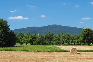
The Taunus is a mountain range in Hesse, Germany, located north west of Frankfurt and north of Wiesbaden. The tallest peak in the range is Großer Feldberg at 878 m; other notable peaks are Kleiner Feldberg and Altkönig.

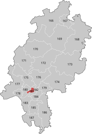
The Hochtaunuskreis is a Kreis (district) in the middle of Hesse, Germany and is part of the Frankfurt/Rhine-Main Metropolitan Region. Neighbouring districts are Lahn-Dill, Wetteraukreis, district-free Frankfurt, Main-Taunus, Rheingau-Taunus, Limburg-Weilburg.

<span class="mw-page-title-main">Oberursel (Taunus)</span> Town in Hesse, Germany

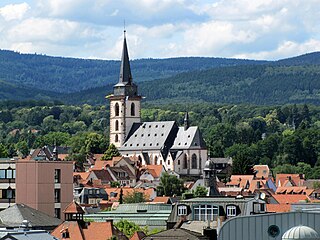
Oberursel (Taunus) (German:[oː.bɐ.ˈʊʁ.zl̩] ) is a town in Germany and part of the Frankfurt Rhein-Main urban area. It is located to the north west of Frankfurt, in the Hochtaunuskreis county. It is the 13th largest town in Hesse. In 2011, the town hosted the 51st Hessentag state festival.

<span class="mw-page-title-main">Eschborn</span> Town in Hesse, Germany

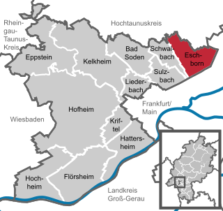
Eschborn is a town in the Main-Taunus district, Hesse, Germany. It is part of the Frankfurt Rhein-Main urban area and has a population of 21,488 (2018). Eschborn is home to numerous corporations due to its proximity to Frankfurt and relatively low business tax rate.

<span class="mw-page-title-main">Kronberg im Taunus</span> Town in Hesse, Germany

Kronberg im Taunus is a town in the Hochtaunuskreis district, Hesse, Germany and part of the Frankfurt Rhein-Main urban area. Before 1866, it was in the Duchy of Nassau; in that year the whole Duchy was absorbed into Prussia. Kronberg lies at the foot of the Taunus, flanked in the north and southwest by forests. A mineral water spring also rises in the town.

<span class="mw-page-title-main">Friedrichsdorf</span> Town in Hesse, Germany

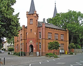
Friedrichsdorf is a town of the Hochtaunuskreis, some 20 km (12 mi) north of Frankfurt am Main in Hesse, Germany.

<span class="mw-page-title-main">Schmitten im Taunus</span> Municipality in Hesse, Germany

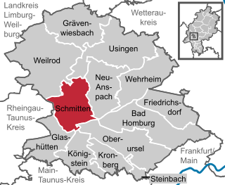
Schmitten im Taunus is a municipality in the Hochtaunuskreis in Hessen, Germany.

<span class="mw-page-title-main">Königstein im Taunus</span> Town in Hesse, Germany

Königstein im Taunus is a health spa and lies on the thickly wooded slopes of the Taunus in Hesse, Germany. The town is part of the Frankfurt Rhein-Main urban area. Owing to its advantageous location for both scenery and transport on the edge of the Frankfurt Rhine Main Region, Königstein is a favourite residential town. Neighbouring places are Kronberg im Taunus, Glashütten, Schwalbach am Taunus, Bad Soden am Taunus and Kelkheim.

<span class="mw-page-title-main">Großer Feldberg</span>

The Großer Feldberg is, at a height of 879.5 metres, the highest elevation of the Taunus mountains, and of the entire Rhenish Massif. It is situated in the Hochtaunuskreis district in Hesse, Germany.

<span class="mw-page-title-main">Wehrheim</span> Municipality in Hesse, Germany

Wehrheim is a municipality in Hesse, Germany some 30 km (20 mi) north of Frankfurt am Main.

<span class="mw-page-title-main">Homburg Railway</span>

The Homburg Railway is an 18 km line from Frankfurt am Main to Bad Homburg in the German state of Hesse. It was opened in 1860 as one of the first railway lines in Germany. It is now part of the Rhine-Main S-Bahn line S5 to Friedrichsdorf.

The Kronberg Railway is now the northern part of Frankfurt S-Bahn line S4, which connects Langen, Frankfurt am Main and Kronberg im Taunusin Hesse, Germany. The route branches off the Homburg line in Rödelheim and continues via Eschborn Süd, Eschborn and Niederhöchstadt to Kronberg.

<span class="mw-page-title-main">Altkönig</span>

The Altkönig is the third highest mountain of the Taunus range in Hesse, Germany, reaching a height of 798.2 m above sea level (NHN).

<span class="mw-page-title-main">Frankfurt-Rödelheim station</span>

Frankfurt-Rödelheim station is a regional and S-Bahn station in western Frankfurt am Main, Germany on the Homburg line, in the district of Rödelheim. The Kronberg line branches off the Homburg line north of the station. The junction with the Rebstock curve of the former Bad Nauheim–Wiesbaden line (Bäderbahn) is south of the station. The station connects with several bus lines.

<span class="mw-page-title-main">Oberursel station</span>

Oberursel (Taunus) station is a station on S-Bahn line S5 in Oberursel (Taunus), near Frankfurt am Main, Germany on the Homburg line. The former Mountain Railway ran from the station to Hohemark; it is now part of U-Bahn line U3.

<span class="mw-page-title-main">U-Bahn Line C (Frankfurt U-Bahn)</span>

The Line C is a line on the Frankfurt U-Bahn. It consists of the U6 and the U7.

<span class="mw-page-title-main">Frankfurt am Main I (electoral district)</span> Federal electoral district of Germany

Frankfurt am Main I is an electoral constituency represented in the Bundestag. It elects one member via first-past-the-post voting. Under the current constituency numbering system, it is designated as constituency 182. It is located in southern Hesse, comprising the western part of the city of Frankfurt am Main.

<span class="mw-page-title-main">Taunus Nature Park</span>

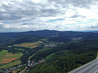
The Taunus Nature Park is a nature park in Central Germany with an area of 134,775 hectares (1347.75 km2) in the Central Upland range of the Taunus. It is one of two Hessian nature parks in the Taunus and the second largest nature park in Hesse.

The 2021 Eschborn–Frankfurt was a road cycling one-day race that took place on 19 September 2021 in the Frankfurt Rhein-Main metro area in southwest Germany. It was the 60th edition of Eschborn–Frankfurt, but only the 58th to be held, and the 27th event of the 2021 UCI World Tour. The race returned to the UCI World Tour calendar after the 2020 edition was cancelled due to the COVID-19 pandemic. Traditionally, the race takes place on 1 May, the Labour Day holiday in Germany, but it was postponed due to COVID-19 precautions.

<span class="mw-page-title-main">Stefan Naas</span> German politician (born 1973)

Stefan Naas is a German politician from the Free Democratic Party. From 2009 to 2018 he served as mayor of the city of Steinbach (Taunus). He has been a member of the Landtag of Hesse since January 2019.

References

  1. "Ergebnisse der letzten Direktwahl aller hessischen Landkreise und Gemeinden" (XLS) (in German). Hessisches Statistisches Landesamt. 5 September 2022.
  2. "Bevölkerung in Hessen am 31.12.2022 nach Gemeinden" (XLS) (in German). Hessisches Statistisches Landesamt. June 2023.