
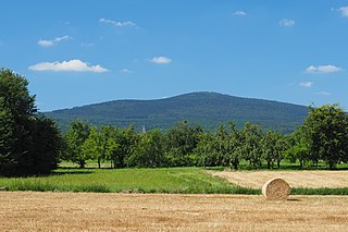
The Taunus is a mountain range in Hesse, Germany, located north west of Frankfurt and north of Wiesbaden. The tallest peak in the range is Großer Feldberg at 878 m; other notable peaks are Kleiner Feldberg and Altkönig.
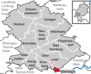
The Hochtaunuskreis is a Kreis (district) in the middle of Hesse, Germany and is part of the Frankfurt/Rhine-Main Metropolitan Region. Neighbouring districts are Lahn-Dill, Wetteraukreis, district-free Frankfurt, Main-Taunus, Rheingau-Taunus, Limburg-Weilburg.
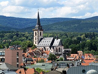
Oberursel (Taunus) (German: [oː.bɐ.ˈʊʁ.zl̩](listen)) is a town in Germany and part of the Frankfurt Rhein-Main urban area. It is located to the north west of Frankfurt, in the Hochtaunuskreis county. It is the 13th largest town in Hesse. In 2011, the town hosted the 51st Hessentag state festival.
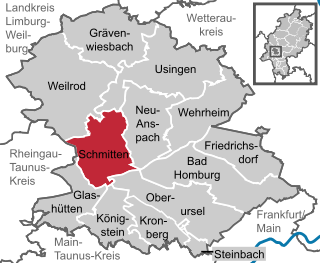
Schmitten im Taunus is a municipality in the Hochtaunuskreis in Hessen, Germany.
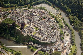
Weilburg is, with just under 13,000 inhabitants, the third biggest town in Limburg-Weilburg district in Hesse, Germany, after Limburg an der Lahn and Bad Camberg.

Königstein im Taunus is a health spa and lies on the thickly wooded slopes of the Taunus in Hesse, Germany. The town is part of the Frankfurt Rhein-Main urban area. Owing to its advantageous location for both scenery and transport on the edge of the Frankfurt Rhine Main Region, Königstein is a favourite residential town. Neighbouring places are Kronberg im Taunus, Glashütten, Schwalbach am Taunus, Bad Soden am Taunus and Kelkheim.
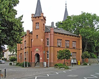
Wehrheim is a municipality in Hesse, Germany some 30 km (20 mi) north of Frankfurt am Main.
Steinbach is a town in the Hochtaunuskreis that borders Frankfurt am Main to the east. Other neighbouring towns are Oberursel, Kronberg im Taunus and Eschborn. It is in the German state of Hesse.

Glashütten is a small municipality in the Hochtaunuskreis. This community in the Taunus, which is made up of the three formerly independent communities of Glashütten, Schloßborn and Oberems, lies in the Hochtaunus Nature Park, not far from Königstein im Taunus, Germany.
The Taunus Railway in the High Taunus is a railway route between Frankfurt (Main) Hauptbahnhof and Brandoberndorf via Bad Homburg, Usingen and Grävenwiesbach. It was operated from 1993 to 1995 by the Frankfurter Verkehrsverbund as the T-Bahn and subsequently by the Rhein-Main-Verkehrsverbund as line 15. It is listed in table 637 of the Deutsche Bahn timetable. The Friedrichsdorf–Brandoberndorf line, which has the infrastructure number of 9374, forms part of the old Friedrichsdorf–Wetzlar line, which was known as the Taunusbahn. The line is owned by the Verkehrsverband Hochtaunus. The infrastructure is managed by HLB Basis AG on behalf of the VHT.
The Altkönig is the third highest mountain of the Taunus range in Hesse, Germany, reaching a height of 798.2 m above sea level (NHN).

The Steinkopf near Ober-Rosbach in the county of Wetteraukreis and Pfaffenwiesbach in the county of Hochtaunuskreis in the German state of Hesse is a hill, 518 m above sea level (NHN), in the eastern Taunus and the easternmost Taunus eminence over 300 m. It has an isolation of 10.170 km and a prominence of 173 m and is thus one of the five independent summits in the Taunus. The Steinkopf is a landmark visible from a long distance especially for the immediately adjacent region of Wetterau to the east.

The Nassau Nature Park is a 561.71 km² nature park in the southwestern Westerwald and northwestern Taunus in Rhineland-Palatinate. It was designated in November 1963 and expanded in 1979.

Falkenstein Castle, also called New Falkenstein (Neu-Falkenstein), is a ruined hill castle at 450 m above sea level (NHN) in the eponymous climatic spa of Falkenstein, a quarter of Königstein im Taunus in the county of Hochtaunuskreis in the German state of Hesse.
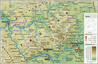
The High Taunus is the name of a major natural region unit in the Hessian Central Uplands range of the Taunus mountains and forms the area immediately around the main ridge of the Taunus. It should not be confused with the term Hochtaunus, in the sense used in the name of the county of Hochtaunuskreis which is only the eastern part of the Feldberg massif. The High Taunus separates the Anterior Taunus in the south from the Lower Taunus in the north and includes the majority of the highest mountains and hills of the Taunus. The eastern part of the natural region lies within the Taunus Nature Park and its western part in the Rhine-Taunus Nature Park.
The Limburg Basin is one of the two large intramontane lowland areas within the Rhenish Massif in Germany, the other being the Middle Rhine Basin. It forms the central part of the natural region of the Gießen-Koblenz Lahn Valley between the Weilburg Lahn Valley Region and the Lower Lahn Valley on both sides of the Lahn around the town of Limburg.

Grävenwiesbach station is the station of Grävenwiesbach on the edge of the Hochtaunuskreis in the German state of Hesse. It is located on the southern outskirts of the town centre. Previously, the station was a junction station that served trains running on the Weil Valley Railway to Weilburg via Weilmünster, on the Taunus Railway to Bad Homburg and on the Solms Valley Railway to Wetzlar.


