
The Taunus is a mountain range in Hesse, Germany, located north west of Frankfurt and north of Wiesbaden. The tallest peak in the range is Großer Feldberg at 878 m; other notable peaks are Kleiner Feldberg and Altkönig.
Main-Taunus is a Kreis (district) in the middle of Hessen, Germany and is part of the Frankfurt/Rhine-Main Metropolitan Region as well as the Frankfurt urban area. Neighboring districts are Hochtaunuskreis, district-free Frankfurt, Groß-Gerau, district-free Wiesbaden, Rheingau-Taunus. It is the second most densely populated rural district in Germany.
Rheingau-Taunus is a Kreis (district) in the west of Hesse, Germany. Rheingau-Taunus-Kreis is part of the Darmstadt region; its main administrative seat is Bad Schwalbach. Outposted sections of the local administration are located in Idstein and Rüdesheim am Rhein.
Limburg-Weilburg is a Kreis (district) in the west of Hesse, Germany. Neighboring districts are Lahn-Dill, Hochtaunuskreis, Rheingau-Taunus, Rhein-Lahn, Westerwaldkreis.
Mainz-Bingen is a district (Kreis) in the east of Rhineland-Palatinate, Germany. Neighboring districts are Rheingau-Taunus, the district-free cities Wiesbaden and Mainz, the districts Groß-Gerau, Alzey-Worms, Bad Kreuznach, and Rhein-Hunsrück.
Rhein-Lahn-Kreis is a district (Kreis) in the east of Rhineland-Palatinate, Germany. Neighboring districts are Westerwaldkreis, Limburg-Weilburg, Rheingau-Taunus, Mainz-Bingen, Rhein-Hunsrück, Mayen-Koblenz, and the district-free city Koblenz.

Rüdesheim am Rhein is a German winemaking town in the Rhine Gorge, and part of the UNESCO World Heritage Site in this region. It lies in the Rheingau-Taunus-Kreis district in the Regierungsbezirk of Darmstadt, Hessen. Known as Rüdesheim, it is officially Rüdesheim am Rhein, to distinguish it from Rüdesheim an der Nahe. It is a major tourist attraction, especially for foreign visitors.

The Rheingau is a region on the northern side of the Rhine between the German towns of Wiesbaden and Lorch near Frankfurt, reaching from the Western Taunus to the Rhine. It is situated in the German state of Hesse and is part of the Rheingau-Taunus-Kreis administrative district. It is famous for Rheingau wines, especially the "Rheingauer Riesling," and its many taverns.

Lorch am Rhein is a small town in the Rheingau-Taunus-Kreis in the Regierungsbezirk of Darmstadt in Hesse, Germany. It belongs to the Rhine Gorge World Heritage Site.

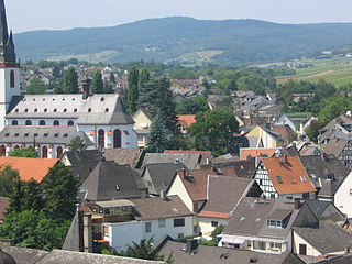
Oestrich-Winkel is a town with roughly 12,000 inhabitants in the Rheingau-Taunus-Kreis in the Regierungsbezirk of Darmstadt in Hesse, Germany.

Heidenrod is a municipality in the Rheingau-Taunus-Kreis in the Regierungsbezirk of Darmstadt in Hesse, Germany. Seat of municipal administration is to be found in the most populated municipal district, in Laufenselden.

Waldems is a municipality in the Rheingau-Taunus-Kreis in the Regierungsbezirk of Darmstadt in Hesse, Germany. The municipality's administrative seat is Waldems-Esch.
The Königssondergau was a Frankish gau (district) which existed in the area north of the confluence of the Rhine and Main rivers in Germany, from Frankish times until the end of the 12th century. Often mistakenly equated with the Rheingau, the Gau was based around the former Roman administrative district of Civitas Mattiacorum. The name Kunigessuntera is documented the first time in 819. A main court (fiscus) with senior officials were present in Wiesbaden; sub-courts existed in Biebrich and Mosbach.

Hohe Wurzel, at 618 m, is the highest peak in the Rheingau-Taunus-Kreis mountain range and the 2nd highest mountain near Wiesbaden, Hesse, Germany. A 133 m reinforced concrete telecommunications tower is located on the peak, which supplies the Rhine Main area and other locations with digital television service as well as DAB and FM sound broadcasts.

The Nassau Nature Park is a 561.71 km2 nature park in the southwestern Westerwald and northwestern Taunus in Rhineland-Palatinate. It was designated in November 1963 and expanded in 1979.
The Taunus Nature Park is a nature park in Central Germany with an area of 134,775 hectares (1347.75 km2) in the Central Upland range of the Taunus. It is one of two Hessian nature parks in the Taunus and the second largest nature park in Hesse.
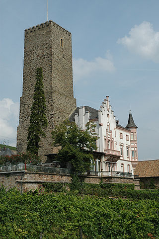
The Boosenburg is a lowland castle in Rüdesheim am Rhein, Rheingau-Taunus-Kreis, Hesse, Germany, located in the Rhine valley and dating back to the 12th century. It is locally known as Oberburg in relation to the near and slightly lower Brömserburg. It has been part of the Rhine Gorge World Heritage Site from 2002.
The Rheingau Mountains or Rheingau Hills form the westernmost section of the High Taunus and extend for 20 kilometres in a south-west to north-east direction between the Rhine valley near Lorch and Assmannshausen in the west and the Walluf valley near Schlangenbad in the east. The highest point is the 619-metre-high mountain of Kalte Herberge. The Rheinhöhenweg Trail on the right bank of the Rhine runs along the ridgeline of the mountains which are part of the main crest of the Taunus.

 Erlenbachtal near Wiesbaden-Frauenstein
 Honigberg near Kiedrich
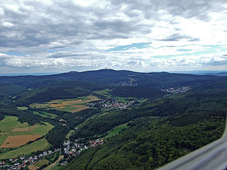
 Highest point of the Rheingau-Taunus-Kreis: 629,3 m high mountain Windhain near Waldems
 View from Windhain mountain over Waldems' constituent communities Niederems and Reinborn
 Viewpoint Isberg-Tempelchen above Niederems


