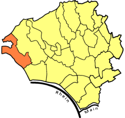
Frauenstein is the westernmost borough of the city of Wiesbaden, located in the Rhine Main Area near Frankfurt and capital of the federal state of Hesse, Germany. The borough has a population of approximately 2,400. The formerly independent village was incorporated into Wiesbaden in 1928.
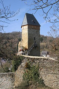
The historic village center is located in the south of the borough. In the center of it are the ruins of a medieval castle, of which the keep still stands. Known as the "Gateway to the Rheingau", the historic village is surrounded by vineyards and fruit orchards. Around late April and early May, its blooming cherry trees make Frauenstein a popular destination.
Geographical setting
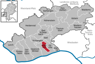
Frauenstein borders the Wiesbaden boroughs of Dotzheim to the north and northeast and Schierstein to the southeast. The town of Schlangenbad lies to the west. The Schlangenbad borough of Georgenborn is almost an enclave, bordered to the north, east, and south by Frauenstein.
The historic village center of Frauenstein is situated in a narrow valley formed by two streams, the Lippbach and Katzbach. These are joined by the Erlenbach south of the village center to form the Grorother Bach. The Grorother Bach flows southeast, reaching the Rhine at Schierstein.
A hill called the Spitzen Stein stands just east of the village center. Other nearby high points include Grauerstein (elevation 339 m) to the northwest and Leierkopf (207 m) to the east. The highest point in Frauenstein is Rotekrauzkopf (elevation 509 m) in the far northwest of the borough. The Frauenstein area is home to a population of the Aesculapian Snake, a large, non-venomous snake rare to this area of Europe.
History
Frauenstein Castle
While the German name Frauen-Stein can be translated "women's stone", it actually derives from Vrowenstein, a name which first appears in the historical record in 1221. In that year, a deed names a Heinrich Bodo von Vrowenstein (in 1207/1209, he was mentioned as being from Idstein) as a lord of Frauenstein Castle.[2] In the year 1231, a document of the Erbach monastery mentions a knight by the name of Siegfried von Frauenstein who was a marshal with the bishopric of Mainz. He was a descendant of an aristocratic Schierstein family (which would become extinct in 1380).[3]
It is not known who built Frauenstein Castle, but, based on dendrochronological evidence, its construction has been dated to around 1184.[2] Built on a quartzite outcropping of the Spitzen Stein the castle was not intended as a defensive fortress, but rather as a watch-tower. It also served the tower guards as a dwelling. The construction of the castle with its high walls and battlements gave protection to farmers in the area and led to the emergence of the village of the same name. Later, the castle was extended by a fore-castle with pond, as could be confirmed by excavations in the year 1943.[3]
Around 1300, Siegfried IV von Frauenstein sold part of the castle, along with surrounding property and its serfs, to Gerhard, the Archbishop of Mainz. Gerhard wanted the castle in order to protect the eastern border of his possessions in the Rheingau against his rival, the Count of Nassau. In May 1301, forces of King Albert of Austria fought against Mainz. They captured all of the fortresses, including Frauenstein, and devastated the Rheingau. The castle was soon restored, however.[2]
In 1310 Johann von Limburg also sold his shares of the castle to the Mainz bishopric so that it had gained full control over the castle by the year 1319. Mainz, however, once again sold parts of the castle so that, by 1390, it possessed only half of the castle. The noble co-owners often settled in Frauenstein and built beautiful half-timbered houses which still stand in the village to the present day.[3]
Over the following centuries, the disputes between Mainz and Nassau continued. Nassau was able to prevent Mainz's possessions in the area from growing by encircling the castle with a chain of five fortified farms: Sommerberg, Rosenkoeppel, Nürnberg, Groroth, and Armada. All of these estates, with the exception of Rosenkoeppel, are still preserved today.[3]
In the second half of the 18th century, the castle lost its significance as border security and was no longer maintained. In the Secularization of 1803, the town was brought under the control of the Count of Nassau and in 1808 the serfs were granted freedom of movement.[2] In 1866, the town - like all of Nassau - came under the control of Prussia.
Religious life
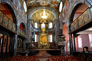
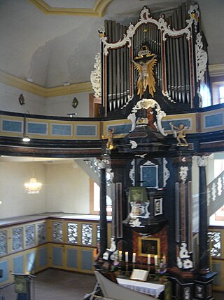
In 1544, the Roman Catholic Archdiocese of Mainz removed Frauenstein from under its parent community of Schierstein and made it an independent parish. The village chapel, built in 1509, was expanded and re-dedicated to St. George and St. Catherine. After secularization, the church received major artworks from the dissolved monasteries, Eberbach Abbey and Tiefenthal, including a Baroque altar. A new church was constructed in 1953 perpendicular to the old church.[2]
The new and old churches
The Protestant Gustav-Adolf Church was established in 1959.[4]
Coat of arms
The present coat of arms of Frauenstein was officially approved in 1951 by the Wiesbaden City Council. It was derived from two old court seals, the "Sigillu(m) Ivdicii Valis Fravwe(n)stein"(with prints dating from 1545 to 1668) and another with prints dating from 1727 to 1791. Both seals are depictions of the legendary battle of St. George and the Dragon. St. George a patron saint of the church. The color red is used to characterize Frauenstein's former position as a possession of the Archbishopric of Mainz.
Since 1928, Frauenstein has been incorporated into Wiesbaden. In municipal heraldry, complete portrayal of persons is largely avoided due to convenience and good visibility of the heraldic elements. Therefore, only parts of people are used in the heraldic shield - here, for example, the arm of St. George.[4]
Attractions
Cherry blossom, 2014Goethestein
On a hill above the town stands the Nürnberger Hof, a former military outpost built by the Count of Nassau in the 14th century. Now owned by the city of Wiesbaden, it has been leased by the Becker family since 1939, who have operated a wine bar there since 1949. In June 1815, during a curative visit to the spas in Wiesbaden, the famous German poet and artist Johann Wolfgang von Goethe spent a lunch at the Hof admiring the "splendid view." His visit was commemorated with the Goethestein, a 13.5 m-high stone obelisk in 1932.[5]
Other well-known estates include the Grorother Hof (established around 1327) and Hof Armada (possibly established as early as c. 1100), both south of the village center, and Schloss Sommerberg (est. 1563) to the west. North of the Grorother Court is the Europa-Wienberg ("Europe-vineyard"), in which are planted various characteristic wine-grape varieties of Europe (described by signs). A mill dating from 1699 also still stands in the southeastern portion of the Gorother Hof estate.
Another famous landmark is the "1000-year old Linden" next to the Catholic Church of St. George and St. Catherine. The fountain in the square in front of the Church is crowned with a figure of St. George. The Falkerscher Hof on Georgstraße and the Schönbornscher Hof on Kirschblütenstraße are well-preserved beautiful half-timbered houses.[6]
Wiesbaden is a city in central western Germany and the capital of the state of Hesse. As of June 2020, it had 290,955 inhabitants, plus approximately 21,000 United States citizens. The Wiesbaden urban area is home to approximately 560,000 people. Wiesbaden is the second-largest city in Hesse after Frankfurt am Main.
Idstein is a town of about 25,000 inhabitants in the Rheingau-Taunus-Kreis in the Regierungsbezirk of Darmstadt in Hesse, Germany. Because of its well preserved historical Altstadt it is part of the Deutsche Fachwerkstraße, connecting towns with fine fachwerk buildings and houses. In 2002, the town hosted the 42nd Hessentag state festival.
Erbenheim is a borough of Wiesbaden, capital of the federal state of Hesse, Germany. It has about 10,000 inhabitants. Formerly an independent municipality, the settlement was incorporated into Wiesbaden on April 10, 1928. Militärflugplatz-Erbenheim is home to U.S. Army Europe and Africa.
The Rheinsteig is a hiking trail following a mainly elevated path along the east bank of the Rhine River in Germany. Its 320 kilometres (200 mi) route stretches from Bonn to Wiesbaden, running parallel to the Rheinhöhenweg Trail and Rheinburgenweg Trail.
Lahnstein is a verband-free town of Rhein-Lahn-Kreis in Rhineland-Palatinate, Germany. It is situated at the confluence of the Lahn with the Rhine, approximately 6 kilometres (3.7 mi) south of Koblenz. Lahnstein was created in 1969 by the merger of the previously independent towns of Oberlahnstein on the south side of the Lahn and Niederlahnstein on the north side. In 2020, it had a population of 18,030.
Eltville am Rhein is a town in the Rheingau-Taunus-Kreis in the Regierungsbezirk of Darmstadt in Hesse, Germany. It lies on the German Timber-Frame Road.
Taunusstein is the biggest town in the Rheingau-Taunus-Kreis in the Regierungsbezirk of Darmstadt in Hessen, Germany. It has 30,068 inhabitants (2020).
Oestrich-Winkel is a town with roughly 12,000 inhabitants in the Rheingau-Taunus-Kreis in the Regierungsbezirk of Darmstadt in Hesse, Germany.
Kiedrich is a municipality in the Rheingau-Taunus-Kreis in the Regierungsbezirk of Darmstadt in Hesse, Germany.
Walluf is a municipality in the Rheingau-Taunus-Kreis in the Regierungsbezirk of Darmstadt in Hesse, Germany. With 5,581 residents in its 6.74 square kilometer area, it is the most densely populated community in the Rheingau-Taunus-Kreis.
The Königssondergau was a Frankish gau (district) which existed in the area north of the confluence of the Rhine and Main rivers in Germany, from Frankish times until the end of the 12th century. Often mistakenly equated with the Rheingau, the Gau was based around the former Roman administrative district of Civitas Mattiacorum. The name Kunigessuntera is documented the first time in 819. A main court (fiscus) with senior officials were present in Wiesbaden; sub-courts existed in Biebrich and Mosbach.
Sonnenberg is a borough of Wiesbaden, the capital of the state of Hesse, Germany. Formerly an independent municipality, Sonnenberg was incorporated into Wiesbaden on 28 October 1926. The borough has approximately 8,000 residents.
Schierstein is a southwestern borough of Wiesbaden, capital of state of Hesse, Germany. First mentioned in historical records in 860, Schierstein was incorporated into Wiesbaden in 1926. Today the borough has about 10,000 residents. Situated on the Rhine River, Schierstein is known as the "Gateway to the Rheingau."
Dotzheim is a western borough of Wiesbaden, capital of the state of Hesse, Germany. It is the second largest borough of the city by area and, with over 27,000 inhabitants the second-most populated of Wiesbaden's suburban boroughs. It was the largest village in the former Duchy of Nassau. The formerly independent village was incorporated into Wiesbaden in 1928.
Klarenthal is a borough of Wiesbaden, capital of the federal state of Hesse, Germany. The community, situated on the slopes of the Taunus Mountains, was planned by architect and urban planner Ernst May in the style of a commuter town in the early 1960s. It was built on free arable land between the railway line to Bad Schwalbach and Klarenthaler Straße, overlooking the city center of Wiesbaden proper. Klarenthal consists mainly of large multi-family homes and residential high-rise buildings, surrounded with much green space, as well as many townhouses. The ground-breaking ceremony was held on September 11, 1964 and the first residents moved in in late February 1966. Today, over 10,000 people live there.
Frauenstein Castle is a ruined castle in the town of Wiesbaden-Frauenstein in Hesse, Germany.
The Unionskirche is the active Protestant parish church of Idstein, a town in the Rheingau-Taunus district in the German state of Hesse. Idstein was a residence of the counts of Nassau. The church building in the center of the historic Altstadt dates back to the 14th century when it was built as a collegiate church. It became Lutheran during the Reformation. Its interior was adapted in the 17th century to become a Lutheran Predigt- und Hofkirche. The most prominent decoration in the church is the series of 38 paintings by the Flemish painter Michael Angelo Immenraedt, an exponent of Flemish Baroque painting, and others. They follow a program of biblical scenes.
Wiesbaden City Palace is a neo-classical building in the center of Wiesbaden, Germany. It was completed in 1841 as the principal city residence of the Dukes of Nassau. The palace has several wings, 145 rooms, and is architecturally integrated with a group of ancillary buildings constructed both before and after it was built. With ornate towers, gables and a slate roof laid in herringbone patterns, the three-story complex lends charm and its name to the central square of Wiesbaden: Palace Square.
The Christophoruskirche is a Protestant church in the borough of Schierstein, Wiesbaden, Germany. It was built in 1752 to 1754 in the style of the late Baroque and Rococo.
Eltville station is the railway station of Eltville in the Rheingau in the German state of Hesse, on the East Rhine Railway from Wiesbaden to Koblenz. It is classified by Deutsche Bahn as a category 5 station.
This page is based on this Wikipedia article Text is available under the CC BY-SA 4.0 license; additional terms may apply. Images, videos and audio are available under their respective licenses.