Wallowa County is one of the 36 counties in the U.S. state of Oregon. As of the 2010 census, the population was 7,008, making it Oregon's fourth-least populous county. Its county seat is Enterprise. According to Oregon Geographic Names, the origins of the county's name are uncertain, with the most likely explanation being it is derived from the Nez Perce term for a structure of stakes used in fishing. An alternative explanation is that Wallowa is derived from a Nez Perce word for "winding water". The journals of Lewis and Clark Expedition record the name of the Wallowa River as Wil-le-wah.

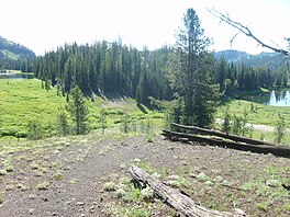
The Wallowa Mountains are a mountain range located in the Columbia Plateau of northeastern Oregon in the United States. The range runs approximately 40 miles (64 km) northwest to southeast in southwestern Wallowa County and eastern Union County between the Blue Mountains to the west and the Snake River to the east. The range is sometimes considered to be an eastern spur of the Blue Mountains, and it is known as the "Alps of Oregon". Much of the range is designated as the Eagle Cap Wilderness, part of the Wallowa–Whitman National Forest.

The Wallowa River is a tributary of the Grande Ronde River, approximately 55 miles (89 km) long, in northeastern Oregon in the United States. It drains a valley on the Columbia Plateau in the northeast corner of the state north of Wallowa Mountains.
The Minam River is a tributary of the Wallowa River, 51 miles (82 km) long, in northeastern Oregon in the United States. It drains a rugged wilderness area of the Wallowa Mountains northeast of La Grande.

The Hells Canyon Wilderness is a wilderness area in the western United States, in Idaho and Oregon. Created 46 years ago in 1975, the Wilderness is managed by both the U.S. Bureau of Land Management and the U.S. Forest Service and contains some of the most spectacular sections of the Snake River as it winds its way through Hells Canyon, North America's deepest river gorge and one of the deepest gorges on Earth. The Oregon Wilderness Act of 1984 added additional acreage and currently the area protects a total area of 217,927 acres (88,192 ha). It lies entirely within the Hells Canyon National Recreation Area except for a small 946-acre (383 ha) plot in southeastern Wallowa County, Oregon which is administered by the Bureau of Land Management. The area that is administered by the Forest Service consists of portions of the Wallowa, Nez Perce, Payette, and Whitman National Forests.

The Lostine River is a 31.4-mile-long (50.5 km) tributary of the Wallowa River in northeastern Oregon in the United States. It drains a portion of the Eagle Cap Wilderness of the Wallowa Mountains in the Wallowa–Whitman National Forest and joins the Wallowa River at Wallowa.

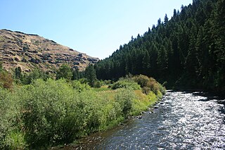
The Imnaha River is a 73.3-mile-long (118.0 km) tributary of the Snake River in the U.S. state of Oregon. Flowing generally east near the headwaters and then north through Wallowa County, the entire river is designated Wild and Scenic. It follows a geologic fault to the Snake River, and in addition to land in the Wallowa–Whitman National Forest and private land, its corridor includes parts of three special management areas: the Eagle Cap Wilderness, Hells Canyon National Recreation Area, and Hells Canyon Scenic Byway. The Imnaha flows by the unincorporated community of Imnaha, the only settlement along its course, and enters the Snake River roughly 4 miles (6 km) from the larger river's confluence with the Salmon River of Idaho and 192 miles (309 km) from its confluence with the Columbia River.
The Wallowa–Whitman National Forest is a United States National Forest in the U.S. states of Oregon and Idaho. Formed upon the merger of the Wallowa and Whitman national forests in 1954, it is located in the northeastern corner of the state, in Wallowa, Baker, Union, Grant, and Umatilla counties in Oregon, and includes small areas in Nez Perce and Idaho counties in Idaho. The forest is named for the Wallowa band of the Nez Perce people, who originally lived in the area, and Marcus and Narcissa Whitman, Presbyterian missionaries who settled just to the north in 1836. Forest headquarters are located in Baker City, Oregon with ranger districts in La Grande, Joseph and Baker City.

The Wallowa Lake Tramway is an aerial cable gondola lift near Joseph, Oregon, in the Wallowa-Whitman National Forest of the United States, named for Wallowa Lake. The tram runs from the floor of the Wallowa Valley to the top of Mount Howard. It travels to an elevation of 8,000 feet (2,400 m) above sea level and allows for views of the Eagle Cap Wilderness area and the rest of the Wallowa Mountains.

Eagle Cap Wilderness is a wilderness area located in the Wallowa Mountains of northeastern Oregon, within the Wallowa–Whitman National Forest. The wilderness was established in 1940. In 1964, it was included in the National Wilderness Preservation System. A boundary revision in 1972 added 73,000 acres (30,000 ha) and the Wilderness Act of 1964 added 66,100 acres (26,700 ha) resulting in a current total of 361,446 acres, making Eagle Cap by far Oregon's largest wilderness area.
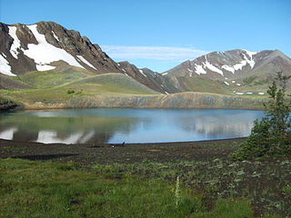
Dollar Lake is a small tarn located on Aneroid Mountain in the Eagle Cap Wilderness of Northeastern Oregon, United States. It is between Aneroid Lake and Bonny Lakes and lies 1 mile (1.6 km) southwest of Aneroid Peak. It likely received its name because of its size and its almost perfectly round shape, much like that of a silver dollar. It is the third-highest lake in the Eagle Cap Wilderness.

In common with many of the neighboring lakes in the Eagle Cap Wilderness of the Wallowa-Whitman National Forest in Wallowa County, Oregon, Aneroid Lake is nestled in an example of a cirque valley with large tarn scoured out of the mountain side by glacial movements during the Pleistocene. Located at the southern foot of Bonneville Mountain the lake and its basin form the headwaters of the East Fork Wallowa River. Aneroid Mountain, namesake of the lake, is about 1.5 miles (2.4 km) to the east, while Roger Lake lies in between a mere .5 miles (0.80 km) away. Dollar Lake is 1.5 miles (2.4 km) to the southeast and Pete's Point 1.5 miles (2.4 km) slightly to the southwest. Because the lake is within the boundaries of the Eagle Cap Wilderness protection area it is inaccessible by any motorized vehicle or any other mechanized mode of travel. However, there is a popular hiking trail for horse and foot traffic. A small group of private cabins that predate the wilderness designation are located beyond the south end of the lake. Aneroid Lake ties with Laverty Lake for the twenty-third highest lake in the Eagle Cap Wilderness at 7,500 ft (2,300 m) elevation.

Roger Lake is a mountain pond located in a meadow on Aneroid Mountain in the Eagle Cap Wilderness of Northeastern Oregon, United States. It is 0.5 miles (0.8 km) from Aneroid Lake on trail 1804. It is listed as the 29th highest lake in the Eagle Cap Wilderness

Billy Jones Lake is a tarn located on Hurricane Divide in the Eagle Cap Wilderness of Northeastern Oregon, United States. It is situated less than one mile from Echo Lake. It is the second highest lake in the Eagle Cap Wilderness at 8,400 ft (2,600 m), though some claim it to be slightly higher at 8,419 ft (2,566 m) or 8,435 ft (2,571 m). The only lake in the Eagle Cap Wilderness that is higher than Billy Jones Lake is Legore Lake at 8,950 ft (2,730 m) located 4 miles (6.4 km) from Billy Jones Lake.
Sacajawea Peak is a peak in the Wallowa Mountains, in the U.S. state of Oregon. It is in the Eagle Cap Wilderness and the Wallowa–Whitman National Forest.
Eagle Creek is a tributary, 41 miles (66 km) long, of the Powder River in the northeastern part of the U.S. state of Oregon. Beginning at Eagle Lake in the Wallowa Mountains, the creek flows generally southwest and then southeast to meet the river near the small city of Richland. The creek's headwaters are in the Eagle Cap Wilderness within the Wallowa–Whitman National Forest. The upper 28.9 miles (46.5 km) of the creek, from Eagle Lake to the national forest boundary at Skull Creek, are part of the National Wild and Scenic Rivers System.

Ice Lake is a small freshwater lake on the south skirt of the Hurwal Divide within the Eagle Cap Wilderness region in Wallowa County, in northeastern Oregon, United States. Its outflow is Adam Creek, which produces several waterfalls including 480 feet (150 m) tall Ice Falls. Ice Lake is the traditional base camp for hikers climbing the Matterhorn, one of the Wallowa Mountains.
East Fork Falls is a waterfall along East Fork Pine Creek in the U.S. state of Oregon just east of Baker City in the south stretch of the Wallowa–Whitman National Forest.

The McCully Basin is a geologic structural basin in the northern boundary of Eagle Cap Wilderness in northeast Oregon. The basin is the topographic drainage of McCully Creek. Several Alpine Huts and campsite are located throughout the McCully Basin, which are used as a base camp in the winter for telemark skiing.
Polaris Pass, Polaris Point or also Polaris Peak, is a 8,890-foot (2,710 m) mountain pass in the Wallowa Mountains in Oregon. It is one of the navigable ridges with the highest elevation within the Eagle Cap Wilderness. Polaris Pass is the drainage divide between the watersheds of the North Fork of the Imnaha River to the West Fork of the Wallowa River. It is located between the southern flanks of Pete's Point and the northern skirt of Sentinel Peak and is traversed by Polaris Trail #1831.