
Gendringen is a village in the Dutch province of Gelderland. It is in the municipality of Oude IJsselstreek, about 12 km (7.5 mi) southeast of Doetinchem and 20 km (12 mi) northwest of the German city Bocholt. It has approximately 4400 inhabitants. In the Middle Ages, Gendringen was a fortress. Being property of the archbishop of Köln (Cologne), Gendringen was loaned to the lords living in the castle of 's-Heerenberg. In 1830, downtown Gendringen burned down for the most part. Nowadays, most of the entrepreneurs of the town are situated in the Grotestraat, which makes this street the most important street of downtown Gendringen. Gendringen was a separate municipality until 2005. Then, due to the municipal re-organization in the Achterhoek, Gendringen and Wisch joined into Oude IJsselstreek.

Alphen aan den Rijn is a city and municipality in the western Netherlands, in the province of South Holland. The city is situated on the banks of the river Oude Rijn, where the river Gouwe branches off. The municipality had a population of 112,587 in 2021, and covers an area of 132.50 km2 (51.16 sq mi) of which 6.27 km2 (2.42 sq mi) is water.

Bodegraven is a town and former municipality in the western Netherlands, in the province of South Holland. The former municipality covers an area of 38.50 km2 (14.86 sq mi) of which 1.02 km2 (0.39 sq mi) is water.

Goeree-Overflakkee is the southernmost delta island of the province of South Holland, Netherlands. It is separated from Voorne-Putten and Hoeksche Waard by the Haringvliet, from the mainland of North Brabant by the Volkerak, and from Schouwen-Duiveland by Lake Grevelingen.

Oude IJsselstreek is a municipality in the province of Gelderland, in the eastern Netherlands. It was established on 1 January 2005 by a merger of the former municipalities of Gendringen and Wisch.
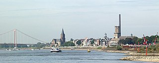
Emmerich am Rhein is a city and municipality in the northwest of the German federal state of North Rhine-Westphalia. The city has a harbour and a quay at the Rhine. In terms of local government organization, it is a medium-sized city belonging to the district of Kleve in the administrative region (Regierungsbezirk) of Düsseldorf.

Oude-Tonge is a village in the Dutch province of South Holland. It is a part of the municipality of Goeree-Overflakkee, and lies about 16 km south of Hellevoetsluis.
Oude Niedorp is a village in the Dutch province of North Holland. It is a part of the municipality of Hollands Kroon, and lies about 6 kilometres (3.7 mi) northeast of Heerhugowaard.

Almkerk is a village in the municipality of Altena, in the Netherlands. It is located about 7 km south of Gorinchem.

Nieuwe Pekela is a village in the Dutch province of Groningen. It is located in the municipality of Pekela, about 7 km southeast of Veendam. The village started as a peat colony, and was named after the river Pekel A. During the 19th century, the village was active in the maritime trade, and contains a museum dedicated to the maritime history. In December 1969, the first women strike of the Netherlands occurred in Nieuwe Pekela.

Oude Pekela is a town in the Dutch province of Groningen. It is located in the municipality of Pekela, about 5 km southwest of Winschoten. It was established to exploit the peat in the area. During the 19th century, it was known for its maritime transport. During the 20th century, Oude Pekela became the centre of the cardboard and potato starch industry.
Etten is a village in the Dutch province of Gelderland. It is located in the municipality of Oude IJsselstreek, 7 km southeast of Doetinchem.

Netterden is a village in the Dutch province of Gelderland. It is located in the municipality of Oude IJsselstreek, about 5 km northeast of Emmerich am Rhein in Germany.

Voorst is a village in the Dutch province of Gelderland. It is located in the municipality of Oude IJsselstreek, about 3 km east of the town of Gendringen.

Oude Wetering is a village in the Dutch province of South Holland. It is located in the municipality of Kaag en Braassem, east of the town of Roelofarendsveen.

Ulft is a town in Oude IJsselstreek in the Achterhoek area in the province of Gelderland, Netherlands.

Silvolde is a village in the Achterhoek and is part of the municipality Oude IJsselstreek.

Varsselder is a Dutch village situated in the Gelderland region Achterhoek, in the municipality Oude IJsselstreek. It is situated directly to the west of Ulft and it is crossed by the road from Ulft to 's-Heerenberg (N816).

Sinderen is a village in the municipality of Oude IJsselstreek in the Dutch province of Gelderland. It is situated at the meeting of three roads, to Varsseveld (north), Dinxperlo (south) and Gendringen, and was on the border of the former municipalities of Gendringen and Wisch.

The DRU Industriepark is the most important cultural centre of the municipality Oude IJsselstreek in the east of the Netherlands. The 'culture factory' in the northeast of the village Ulft is situated by the river Oude IJssel, Netherlands.


