
Buren is a town and municipality in the Betuwe region of the Netherlands. Buren has 27.168 inhabitants as of 1 January 2022.

Gendringen is a village in the Dutch province of Gelderland. It is in the municipality of Oude IJsselstreek, about 12 km (7.5 mi) southeast of Doetinchem and 20 km (12 mi) northwest of the German city Bocholt. It has approximately 4400 inhabitants. In the Middle Ages, Gendringen was a fortress. Being property of the archbishop of Köln (Cologne), Gendringen was loaned to the lords living in the castle of 's-Heerenberg. In 1830, downtown Gendringen burned down for the most part. Nowadays, most of the entrepreneurs of the town are situated in the Grotestraat, which makes this street the most important street of downtown Gendringen. Gendringen was a separate municipality until 2005. Then, due to the municipal re-organization in the Achterhoek, Gendringen and Wisch joined together into Oude IJsselstreek.

Neerijnen is a village and former municipality in the Netherlands. It is about 35 kilometres (22 mi) south of Utrecht and some 15 kilometres (9.3 mi) north of 's-Hertogenbosch.

Hagestein is a village and former city in the municipality of Vijfheerenlanden, Utrecht, Netherlands, on the Lek River, about 2 km east of Vianen. It received city rights in 1382. Hagestein was destroyed in 1405 by the Count of Holland and the Prince-Bishop of Utrecht.

Terborg is a small city in the Dutch province of Gelderland, in the Achterhoek region in the east of the Netherlands. It is located in the municipality of Oude IJsselstreek. The city lies about 7 km southeast of Doetinchem. The population is about 4600 inhabitants.

Oude IJsselstreek is a municipality in the eastern Netherlands. It was established on 1 January 2005 through a merger of the former municipalities Gendringen and Wisch.

Loenen aan de Vecht is a village in the Dutch province of Utrecht. It was the main village in the former municipality of Loenen. Since 2011 it has become part of the newly formed municipality of Stichtse Vecht. It lies about 10 km west of Hilversum.

Nieuwer-Ter-Aa is a village in the Dutch province of Utrecht (province). It is a part of the municipality of Stichtse Vecht, and lies about 13 km northwest of Utrecht.
Zoelen is a village in the Dutch province of Gelderland. It is a part of the municipality of Buren, and lies about 3 km north of Tiel. Castle Zoelen is located near the village.

Ophemert is a village in the Dutch province of Gelderland. It is a part of the municipality of West Betuwe, and lies about 5 km south of Tiel.

Echteld is a village in the Dutch province of Gelderland. It is a part of the municipality of Neder-Betuwe, and lies about 6 km east of Tiel.

Ewijk is a village in the Dutch province of Gelderland. It is a part of the municipality of Beuningen, and lies about 9 km west of Nijmegen. The river Waal runs in the north.

Pieterburen is a village in the northeastern Netherlands, located in the municipality of Het Hogeland, Groningen.

Steenwijkerwold is a village in the Dutch province of Overijssel. It is located in the municipality of Steenwijkerland, about 5 km northwest of Steenwijk. Steenwijkerwold was a separate municipality until 1973, when it became a part of Steenwijk.
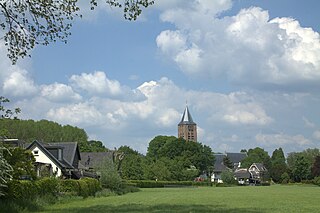
Etten is a village in the Dutch province of Gelderland. It is located in the municipality of Oude IJsselstreek, 7 km southeast of Doetinchem.

Voorst is a village in the Dutch province of Gelderland. It is located in the municipality of Oude IJsselstreek, about 3 km east of the town of Gendringen.

Hoenderloo is a Dutch village located south west of the city of Apeldoorn. Most of the village is part of the municipality of Apeldoorn, but a small part belongs to the municipality of Ede, among which the hamlet Hoog Baarlo.

Ulft is a town in Oude IJsselstreek in the Achterhoek area in the province of Gelderland, Netherlands.

Eijsden-Margraten (Dutch pronunciation: [ˌɛizdəˈmɑrɣraːtə ]; is a municipality situated in the very south of the Netherlands. There it is located in the southeastern part of the province of Limburg.

Bussloo is a village in the municipality of Voorst in the province of Gelderland, the Netherlands. On the beach De Kuiter, on the South Western side of the lake, nudist recreation is permitted.


