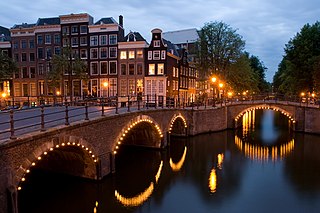
Amsterdam is the capital and most populous city of the Netherlands, with The Hague being the seat of government. It has a population of 907,976 within the city proper, 1,558,755 in the urban area and 2,480,394 in the metropolitan area. Located in the Dutch province of North Holland, Amsterdam is colloquially referred to as the "Venice of the North", for its large number of canals, now designated a UNESCO World Heritage Site.

Holland is a geographical region and former province on the western coast of the Netherlands. From the 10th to the 16th century, Holland proper was a unified political region within the Holy Roman Empire as a county ruled by the counts of Holland. By the 17th century, the province of Holland had risen to become a maritime and economic power, dominating the other provinces of the newly independent Dutch Republic.

The Netherlands, informally Holland, is a country located in Northwestern Europe with overseas territories in the Caribbean. It is the largest of four constituent countries of the Kingdom of the Netherlands. The Netherlands consists of twelve provinces; it borders Germany to the east, Belgium to the south, with a North Sea coastline to the north and west. It shares maritime borders with the United Kingdom, Germany and Belgium in the North Sea. The country's official language is Dutch, with West Frisian as a secondary official language in the province of Friesland. Dutch Low Saxon and Limburgish are recognised regional languages, while Dutch Sign Language, Sinte Romani and Yiddish are recognised non-territorial languages. Dutch, English and Papiamento are official in the Caribbean territories.

The Hague is a city and municipality of the Netherlands, situated on the west coast facing the North Sea. The Hague is the country's administrative centre and its seat of government, and while the official capital of the Netherlands is Amsterdam, The Hague has been described as the country's de facto capital. The Hague is also the capital of the province of South Holland, and the city hosts both the International Court of Justice and the International Criminal Court.
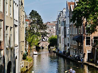
Utrecht is the fourth-largest city and a municipality of the Netherlands, capital and most populous city of the province of Utrecht. It is located in the eastern corner of the Randstad conurbation, in the very centre of mainland Netherlands, about 35 km south east of the capital Amsterdam and 45 km north east of Rotterdam. It has a population of 361,966 as of 1 December 2021.
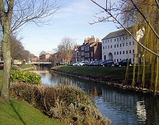
Spalding is a market town on the River Welland in the South Holland district of Lincolnshire, England. The town had a population of 31,588 at the 2011 census. The town is the administrative centre of the South Holland District. The town is located between the cities of Peterborough and Lincoln, as well as the towns of Bourne, March, Boston, Wisbech, Holbeach and Sleaford.

Gramsbergen is a small Dutch city on the Vechte, located in the municipality of Hardenberg and the province of Overijssel. The town is located on corridors of different transportation modes: The N34, the Zwolle - Emmen railway and the Almelo - de Haandrik canal.

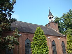
Oude IJsselstreek is a municipality in the eastern Netherlands. It was established on 1 January 2005 through a merger of the former municipalities Gendringen and Wisch.

Ouddorp is a village in the Dutch province of South Holland. It is part of the municipality of Goeree-Overflakkee. It is often referred to as Ouddorp aan Zee to promote itself as a seaside resort, because the village has an 18 kilometres (11 mi) long beach which is the longest of the Netherlands.

Broekhuizenvorst is a village in the Dutch province of Limburg. It is a part of the municipality of Horst aan de Maas and lies at 18 km north of Venlo.

Nibbixwoud is a village in the Dutch province of North Holland. It is a part of the municipality of Medemblik, and lies about 5 km north of Hoorn.
Koudekerke is a village in the region of Walcheren in the Dutch province of Zeeland. It is a part of the municipality of Veere. As of 2018, the census reported the village has a population of 3,419, making it the largest settlement in Veere. The built-up area of the village was 0.55 km², and contained 1,133 residences.

Varik is a village in the Dutch province of Gelderland. It is a part of the municipality of West Betuwe, and lies about 8 km south of Tiel.

Groede is a village in the Dutch province of Zeeland. It is located about 5 km north of Oostburg in the municipality of Sluis.

Velp is a village in the Dutch province of North Brabant. It is located in the former municipality of Grave, about 2 km southwest of the city. Until 1794, it was part of the Land van Ravenstein, a Catholic enclave of Palatinate-Neuburg within the Dutch Republic.

Broek is a small village in De Fryske Marren in the province of Friesland, the Netherlands. It had a population of around 190 in 2017.

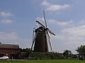
De Kempermolen is a tower mill in Breedenbroek, Gelderland, Netherlands which was built in 1882 and has been restored to working order. The mill is listed as a Rijksmonument.

Land van Cuijk is a municipality in the province of North Brabant, the Netherlands, formed from the merger of Boxmeer, Cuijk, Sint Anthonis, Mill en Sint Hubert and Grave. The municipality came into existence on 1 January 2022. It belongs to the region of De Peel.
Tolbert is a town in the Dutch province of Groningen. It is part of the municipality of Westerkwartier and forms a single urban area with Leek.

Westernieland is a village in the Dutch province of Groningen. It is part of the municipality of Het Hogeland. The village is located near the Wadden Sea.